Dragensdorf
|
Dragensdorf
Dittersdorf municipality
Coordinates: 50 ° 38 ′ 46 " N , 11 ° 50 ′ 4" E
|
|
|---|---|
| Height : | 453 m above sea level NN |
| Area : | 3.07 km² |
| Residents : | 72 (December 31, 2009) |
| Population density : | 23 inhabitants / km² |
| Incorporation : | December 1, 2010 |
| Postal code : | 07907 |
| Area code : | 036648 |
|
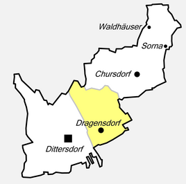
Location of Dragensdorf in Dittersdorf
|
|
|
St. Catherine's Church
|
|
Dragensdorf is a district of the municipality of Dittersdorf in the Lake District administrative community in the Saale-Orla district in Thuringia .
history
In 1990 the former municipality became a member of the Oettersdorf Administrative Community, which was renamed the Seenplatte Administrative Community in 1993. On December 1, 2010 it became a district of Dittersdorf. Until then, it was the smallest municipality in the Saale-Orla district in terms of population.
Population development
Development of the population (December 31st each) :
|
|
|
|
- Data source: Thuringian State Office for Statistics
Attractions
The townscape is characterized by a number of ponds. In the center of the village is the church of St. Katharinen , a hall church which was originally Gothic and was expanded in 1684. It contains a winged altar from around 1500, a wall mosaic depicting the Apocalypse, a baptismal font from 1684 and a modern pulpit .

