Schlegel (Rosenthal am Rennsteig)
|
Schlegel
Rosenthal am Rennsteig municipality
|
|
|---|---|
| Coordinates: 50 ° 24 ′ 17 ″ N , 11 ° 37 ′ 12 ″ E | |
| Height : | 620 m |
| Area : | 12.29 km² |
| Residents : | 299 (December 31, 2017) |
| Population density : | 24 inhabitants / km² |
| Incorporation : | 1st January 2019 |
| Postal code : | 07366 |
| Primaries : | 036642, 036651 |
|
Location in the city of Rosenthal am Rennsteig, founded in 2019
|
|
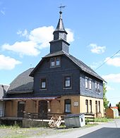
Schlegel is a district of the municipality of Rosenthal am Rennsteig in the south of the Saale-Orla district in Thuringia .
geography
The place is located directly on the Rennsteig, about eight kilometers south of Bad Lobenstein . The southern municipal border formed the state border between Thuringia and Bavaria .
history
Schlegel was first mentioned on June 24, 1254 and Seibis in 1500.
On July 1, 1950, the previously independent municipality of Seibis became a district of Schlegel. That can't be quite right either! In 1952, Seibis was deprived of independence in the local history and website of the administrative association.
On January 1, 2019, the communities Schlegel, Blankenberg , Blankenstein , Harra , Neundorf , Birkenhügel and Pottiga merged to form Rosenthal am Rennsteig . All the municipalities of this municipality merger had belonged to the Saale-Rennsteig administrative community since 1994 .
Population development
Development of the population (as of December 31st) :
|
|
|
|
- Data source: Thuringian State Office for Statistics
Attractions
On the gable of the former municipal office, a representation of a horse is incorporated into the slate cladding.
The oldest wild apple tree in the Thuringian Forest is in Schlegel . It is listed as a natural monument in the Saale-Orla district under the register no. ND SOK 37 led. Its age is estimated to be about 400 years, the trunk diameter is about 1 meter and its height is about 5 meters.
Individual evidence
- ^ According to the Saale-Rennsteig administrative association website, it was first mentioned in 1352.
- ^ Wolfgang Kahl : First mention of Thuringian towns and villages. A manual. 5th, improved and considerably enlarged edition. Rockstuhl, Bad Langensalza 2010, ISBN 978-3-86777-202-0 , pp. 250, 262.
- ^ Federal Statistical Office: Municipalities 1994 and their changes since 01.01.1948 in the new federal states . Metzler-Poeschel, Stuttgart 1995, ISBN 3-8246-0321-7 .
- ↑ Thuringian Law and Ordinance Gazette No. 14/2018 p. 795 ff. , Accessed on May 20, 2019
- ↑ Ordinance on the protection of individual creations of nature as a natural monument in the Saale-Orla district (PDF; 93 kB) of March 25, 2008, accessed on January 14, 2017
- ↑ Information board at the western entrance to the village


