Arlas
|
Arlas
Rosenthal am Rennsteig municipality
Coordinates: 50 ° 25 ′ 1 ″ N , 11 ° 42 ′ 48 ″ E
|
|
|---|---|
| Height : | 543 m above sea level NHN |
| Postal code : | 07366 |
| Area code : | 036642 |
|
Location in the city of Rosenthal am Rennsteig, founded in 2019
|
|
|
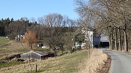
Look at Arlas
|
|
Arlas is a district of Rosenthal am Rennsteig and is located in the southeastern Saale-Orla district .
geography
Arlas, about one and a half kilometers north of Blankenberg , on the edge of the forest and on both sides of the Arlasbach, is now a district of Rosenthal am Rennsteig.
history
Arlas was first mentioned in a document in 1343. The spelling was also Arles, Marles and in earlier times maple. Due to the Arlasbach, the place used to belong to two different states. The north-western part belonged to the Reussian rule Lobenstein , while the south-eastern part, with the place Blankenberg, belonged to the administrative district of Erfurt in the Kingdom of Prussia . This was a consequence of the Congress of Vienna in 1815, when the Kingdom of Saxony, allied with Napoleon , had to cede considerable parts of its territory to Prussia.
Arlas Church
The Ahorns chapel was first mentioned in a document from the parish of Hof in 1479. However, it can be assumed that the church is much older. In any case, it dates from the early Middle Ages, was originally considered a so-called field church and is said to have been consecrated to St. Mary, for whose image pilgrimages from the area are said to have taken place. Former remains of a moat indicated that the complex was fortified.
In 1343 the church fell victim to the fire. In later centuries renovations were repeatedly necessary, for example in 1446 and 1637. In the latter year as a result of a fire. On May 23, 1637, the carelessness of one of Blankenberg's residents set fire to brushwood near the clapboard-covered chapel, causing a fire. After the last construction, the church consisted of a room eleven to twelve meters long and almost equally wide, which was oriented from the southwest to the northeast. Around the church there was the church field where the residents of Blankenberg buried their dead.
In the earlier years Arlas belonged to Gefell ecclesiastical , then came to Berg and in 1626 with restrictions to Sparnberg in the parish of Berg. The service took place in the chapel alternating with the church in Sparnberg every Sunday. After 1637, following a complaint from the pastor von Berg, for whom the extensive branch service in his district, even if there were some vicarious clergy, was too much, services were only held four times a year, namely at Easter, Pentecost and Christmas, as well as on Sunday after Ascension, for the parish fair. On Ascension Day, large crowds of the faithful came to Arlas to receive indulgences in the chapel there. The indulgence days then became folk festivals and markets. They existed until the first third of the 19th century and were later moved to neighboring Pottiga .
On May 1, 1824, the church of Arlas was closed due to dilapidation and danger of collapse. The Russian part of Arlas was pastured to Frössen and the Prussian part with Blankenberg received its own prayer room in the old Blankenberg schoolhouse. The church activities were still carried out by the pastor zu Berg and the dead Blankenberger were buried until 1846 in the cemetery of the Arlaser church. In 1869 the last remains of the church were removed.
Individual evidence
- ^ Wolfgang Kahl : First mention of Thuringian towns and villages. A manual. 5th, improved and considerably enlarged edition. Rockstuhl, Bad-Langensalza 2010, ISBN 978-3-86777-202-0 , pp. 34 and 19.

