
Blankenberg (Rosenthal am Rennsteig)
|
Blankenberg
Rosenthal am Rennsteig municipality
|
|
|---|---|
.png) |
|
| Height : | 400 m above sea level NHN |
| Area : | 3.74 km² |
| Residents : | 813 (December 31, 2017) |
| Population density : | 217 inhabitants / km² |
| Incorporation : | 1st January 2019 |
| Postal code : | 07366 |
| Area code : | 036642 |
|
Location of Blankenberg in the Saale-Orla district
|
|
Blankenberg is a district of the municipality of Rosenthal am Rennsteig in the Saale-Orla district in Thuringia .
geography
Geographical location
Blankenberg is located in the south of the Saale-Orla district , where the Saale , coming from Bavaria, continues its way through Thuringia and flows around the place in an arc. The community extends along a ridge. The Anger lies at an altitude of about 460 m above sea level. NN , the church at 500 m above sea level. NN and the sports field at Galgenbühl at 560 m above sea level. NN.
Neighboring places
Neighboring places are Blankenstein , Harra and Pottiga in the Saale-Orla district and Issigau in the Bavarian district of Hof .
history
The first documented mention of the "Veste Planckenberg" comes from January 9, 1212. This castle can be regarded as the ancestral seat of the von Blanckenberg family and changed hands several times after the family died out.
Until around 1258 Blankenberg was an imperial fiefdom and part of the Regnitzland formed by the Staufers , administered by the bailiffs of Gera . From 1258 Blankenberg belonged to the margraviate of Meißen . In 1371 it was sold to the Bohemian kings and was henceforth a Bohemian crown fief. From 1422 the part of the Vogtland in Bohemia, including Blankenberg, came to the Electors of Saxony. The affiliation to Electoral Saxony remained until 1815. From 1547 to 1563 it was in the fief of the Lords of Plauen and Burgraves of Meißen .
But also within Electoral Saxony , the rule of Blankenberg changed frequently. Blankenberg, with the Plauen office, was under the Ernestine line from 1485 to 1547 , the Albertine line from 1563 to 1656 and the Duchy of Saxony-Zeitz from 1656 to 1718 . This line expired in 1718 and ownership fell again to Electoral Saxony, which was incorporated into the Kingdom of Saxony in 1806 .
With the Congress of Vienna in 1815, as a result of which Saxony suffered major territorial losses, Blankenberg came under the control of Prussia and belonged as an exclave to the newly formed district of Ziegenrück .
On February 25, 1947, the Allied Control Council declared Prussia to no longer exist. Blankenberg thus belonged to Thuringia , which was newly founded as one of the five countries of the Soviet occupation zone . Four years later, Thuringia, like the rest of the GDR countries, was dissolved and Blankenberg became part of the Gera district .
The medieval Blankenberg Castle, rebuilt into a palace since the early modern era, was blown up on June 14, 1948 on the basis of Order No. 209 of the Soviet Military Administration in Germany . Structural remains of the castle were uncovered after 1990. In 2007, on the occasion of the 775th anniversary, a 1:10 scale model of the castle was set up on a roundabout at the foot of the ruin.
On January 1, 2019, Blankenberg and its Arlas district merged with six other communities to form the single community Rosenthal am Rennsteig . Blankenberg has been part of the Saale-Rennsteig administrative community since 1994 .
Population development
Population development before 1994

Population development since 1994
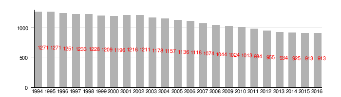
(As of December 31st):
religion
38% of the residents of Blankenberg are Protestant, 1% Catholic. The Gnadenkirche belongs to the parish of Blankenberg in the Schleiz parish of the Evangelical Church in Central Germany . The Catholics are affiliated to the parish of St. Paulus , based in Schleiz , Diocese of Dresden-Meißen , whose next branch church is Christ the King in Bad Lobenstein , about 10 km away . A little closer is the parish church of Maria Königin des Friedens in Bad Steben , Upper Franconia , in the Archdiocese of Bamberg .
politics
Municipal council
Since the 2014 municipal council elections , the council has been composed as follows:
mayor
In the mayoral elections on June 27, 2004, Hans Wietzel (SPD) received an absolute majority with 98.4% of the votes in the first ballot and thus entered his second term of office.
In the mayoral elections on June 6, 2010, he again received an absolute majority for his third term of office with 98.9% of the votes in the first ballot.
coat of arms
The coat of arms shows the Blankenberg Castle. The trees represent the wealth of forests in the region, the river symbolizes the Saale and the three paper rolls represent the paper mill and the local paper industry.
Culture and sights
Mercy Church
The Gnadenkirche zu Blankenberg is built in the neo-Romanesque style in an east-west direction. Their outer walls are made of unplastered natural stone.
In 1852 the decision was made to build a church in Blankenberg, as the church in Arlas had to be closed due to the risk of collapse. However, the construction project repeatedly failed due to the necessary financial resources. According to a ministerial declaration by the royal Bavarian State Ministry on April 14, 1860, which had been preceded by negotiations between Bavaria and Prussia since 1856, Blankenberg got its own parish and was separated from the mother church in Berg . After the planning phase, the royal Prussian master builder Otto Hentsch was entrusted with the construction management, and the groundbreaking ceremony took place on May 12, 1860. Generous donations from the Blankenberg paper manufacturer Flinsch and the Prussian king and later German emperor Wilhelm I enabled the building of the church to progress rapidly.
The building material was mainly obtained from the local area. The stones came from the Egelkraut quarry in Blankenberg, the wood from the Reussian forest in Arlas and the sand from the Pottigaer Flur. The topping-out ceremony was celebrated on June 7, 1861, and the church was consecrated on October 15, 1862.
Rectory
The hunter's house, which belonged to the Blankenberg manor at that time, was bought after the church was built and set up as a parsonage. Dating information on the parish building is missing. However, the proportions, the design and the facade details suggest that this is a building from the middle or late 18th century. You can still see the small park-like area in front of the building.
Fallen memorial
On November 23, 1923, in front of the north side of the church, between two hanging birches, a war memorial made of bob green lime marble was inaugurated for those who fell in the First World War . In 1998, two memorial plaques with the names of the Blankenberg victims of the Second World War were placed on the right and left of the war memorial, the old war memorial was completely renovated. In the meantime, the fallen were remembered on a plaque inside the church.
graveyard
The Blankenberg dead were buried earlier in Berg and until 1846 also in the church near the Arlas church. Both Prussian and Russian residents took advantage of this. In 1846, Blankenberg laid out its own church in the village. In 1917, the parish acquired the adjacent parish meadow from the church to expand the cemetery, on which the Blankenberg master builder Vogel built the morgue in 1925. The family tomb of the Flinsch family of papermakers was located in the Blankenberg cemetery.
More Attractions
One of the sights of the community is the former paper mill with the paper machine built in 1903 and commissioned in 1906, which is considered the second oldest paper machine in Germany.
The remains of the castle, which have been uncovered since the beginning of the 1990s, can be viewed at the former location of the castle. The tournament area is clearly recognizable with the newly built gate. The retaining walls were partly rebuilt; a palace garden with a pavilion was created. The cross vault of the manor building was restored and a small collection of finds from the excavations was set up there. A 1:10 scale model of the castle was placed on a roundabout at the foot of the ruin.
Since Blankenberg lies on a mountain saddle above the Saale, some newly designed lookout points offer a view of the Saale valley. There are views of Blankenstein and Lichtenberg from the gypsy hill and the wedding basket . From the palace garden, the view sweeps down into the Saale valley, to Kemlas and Berg.
Economy and Infrastructure
Blankenberg owes its boom and prosperity to the water power of the Saale. A mill was mentioned in a document in 1371 when Emperor Charles IV and his son Wenzel bought the Blankenberg fortress from the bailiffs of Gera on March 23rd of that year. The mill was explicitly highlighted. It was a water mill that was marked on a map from 1757, but later burned down. Traces of the mill trench are still present below the Angerhäuser on the Saale. A paper mill is also shown on the card mentioned, which was owned by the paper merchant Johann Wolfgang Rahm from Hof in Bavaria in the second half of the 18th century .
Blankenberg paper mill
Paper production in Blankenberg is closely associated with the Flinsch family. Adam Erdmann Flinsch (1757–1828) leased the paper mill in Blankenberg from the owner at the time, and ran it into old age. The eldest son, Johann Christian Flinsch, born on May 9th, 1788 in Blankenberg, bought the paper mill in the 20s of the 19th century. His three brothers, Ferdinand Traugott , Carl and Heinrich Flinsch, all born in Blankenberg, made the name Flinsch a respected brand in the paper industry. 1842–1843 the brothers converted their father's paper mill in Blankenberg into a machine paper factory. The paper machine was 60 inches (1525 mm) wide and was made by Bryan Donkin in London. After the renovation, the company employed 70 people and provided the residents with an opportunity to earn a living, especially since mining came to a standstill around this time.
On December 6, 1894, the owner of the paper factory in the neighboring town of Blankenstein , Gotthelf Anton Wiede , bought the Blankenberg paper factory . The object of purchase consisted of the paper factory with accessories, forest, meadows, fields, the old Katzenhammer hammer mill with residential house and stable buildings and the village house No. 102. The manor house with garden and a forest of 80 hectares on the Bavarian side came together with the Wolfstein and its own Hunting justice added.
traffic
With the KomBus line 720 , Blankenberg has a connection to the cities of Bad Lobenstein , Schleiz and Tanna .
Personalities
- Ferdinand Traugott Flinsch (1792–1849), paper manufacturer
- Friedrich Oelze (1873–1954), educator and politician (DNVP)

Blankenberg castle ruins

Archway to the tournament site

Saale valley near Blankenberg


literature
- A visit to a paper mill . In: Illustrirte Zeitung . No. 38 . J. J. Weber, Leipzig March 16, 1844, p. 190 ( books.google.de ).
Web links
Individual evidence
- ^ Otto Dobencker : Regesta diplomatica necnon epistolaria historiae Thuringiae. Volume 2, Part 2: 1210-1227. Fischer, Jena 1900, no.1496 .
- ↑ Thuringian Law and Ordinance Gazette No. 14/2018 p. 795 ff. , Accessed on May 20, 2019
- ↑ Data source: Thuringian State Office for Statistics
- ↑ 2011 census
- ↑ http://www.wahlen.thueringen.de/datenbank/wahl1/wahl.asp?wahlart=GW&wJahr=2014&zeigeErg=GEM&auswertung=1&wknr=075&gemnr=75003&terrKrs=&gemteil=000&buchstabe=&Langname=x&wahlvorschlag=&sort=&druck=&XLS=&anzahlH = -1 & non_existing = & x_vollbildDatteil = & optik = & aktuell = & ShowLand = & ShowWK = & ShowPart =