Eating
|
Issig Issigbach |
||
|
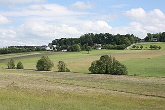
Issiggrund near Reitzenstein , in the middle of the picture the brook, |
||
| Data | ||
| Water code | DE : 5616994 | |
| location | Hof district | |
| River system | Elbe | |
| Drain over | Selbitz → Saale → Elbe → North Sea | |
| origin | Confluence of the Krebsbach and the Bach von Rothleiten on the road between Berg and Naila ;
(Quellbach in the Rothleitener Forest: 50 ° 21 ′ 0.4 ″ N , 11 ° 45 ′ 42.2 ″ E ) |
|
| Source height | Confluence 573 m (headwaters approximately 605 meters) | |
| muzzle | in Naila -Hellle in Selbitz Coordinates: 50 ° 22 ′ 3 ″ N , 11 ° 41 ′ 29 ″ E 50 ° 22 ′ 3 ″ N , 11 ° 41 ′ 29 ″ E |
|
| Mouth height | approx. 485 m | |
| Height difference | approx. 88 m | |
| Bottom slope | approx. 12 ‰ | |
| length | 7.6 km | |
| Communities | Berg , Issigau , Naila | |
The Issig , which is also called Issigbach , is an almost eight kilometers long right tributary of the Selbitz in the Bavarian administrative district of Upper Franconia.
course
The source streams of the Issig arise in the Rothleitener forest near Berg . Up to the crossing of the Berg – Rothleiten road near the quarry, the waters are also known as the Krebsbach . The single stone green with the farm name Mohrnhaus is above the stream. In the past, the house was supplied with water from the Issig via a hydraulic ram . At the village of Reitzenstein the Issig drove the mill located outside the village. In the next town, Issigau , the brook gave its name. Here, too, the water of the stream was used for grinding. The Issigauer mill stood in the center of the village. Shortly after Issigau, Issig drove another mill, the Neuenmühle (approx. 510 m high), a cutting mill. In Hölle, a district of the town of Naila at the entrance to the Höllental , the Issig crosses a residential street and then the former railway line and flows into the Selbitz at a height of approx. 485 m opposite the Stebenbach .
literature
- Otto Knopf , Helmut Süssmann: Thuringian Slate Mountains, Franconian Forest, Obermainisches Bruchschollenland. Dictionary. Ackermann-Verlag, Hof 1993, ISBN 3-929364-08-5 .
