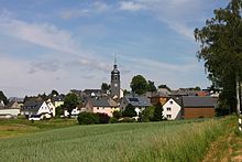
Leupoldsgrün
| coat of arms | Germany map | |
|---|---|---|

|
Coordinates: 50 ° 17 ' N , 11 ° 48' E |
|
| Basic data | ||
| State : | Bavaria | |
| Administrative region : | Upper Franconia | |
| County : | court | |
| Management Community : | Schauenstein | |
| Height : | 610 m above sea level NHN | |
| Area : | 10.25 km 2 | |
| Residents: | 1201 (Dec. 31, 2019) | |
| Population density : | 117 inhabitants per km 2 | |
| Postal code : | 95191 | |
| Area code : | 09292 | |
| License plate : | HO , MÜB , NAI, REH , SAN | |
| Community key : | 09 4 75 145 | |
| LOCODE : | DE EAA | |
| Community structure: | 6 districts | |
| Address of the municipal administration: |
Rathausplatz 1 95191 Leupoldsgrün |
|
| Website : | ||
| Mayoress : | Annika Popp ( CSU ) | |
| Location of the municipality of Leupoldsgrün in the district of Hof | ||
Leupoldsgrün is a municipality in the Upper Franconian district of Hof and a member of the Schauenstein administrative community . The community is located about nine kilometers west of the district town of Hof on the A 9 motorway (junction 34 Hof / West).
geography
Geographical location
Leupoldsgrün is located in the Franconian Forest Nature Park .
Neighboring communities
Adjacent municipalities are:
| Selbitz | court | |
| Schauenstein |

|
|
| Helmbrechts | Konradsreuth |
Districts
The municipality of Leupoldsgrün is divided into six districts:
There is also a lime kiln.
history
Until the church is planted
The first documented mention of Leupoldsgrün dates from 1335. The von Lüchau family can be traced back to the period from 1398 to 1668. The property then passed to the Baum von Baumsdorf family , who died out in 1725. The former office of the Principality of Bayreuth fell to France in the Peace of Tilsit in 1807 and became part of Bavaria in 1810 . In the course of the administrative reforms in Bavaria, today's municipality was created with the municipal edict of 1818 .
Incorporations
On July 1, 1972, the formerly independent municipality of Lipperts was incorporated.
Outsourcing
On July 1, 1976, parts of the area with then significantly fewer than 50 inhabitants were ceded to the city of Selbitz .
Population development
In the period from 1988 to 2018, the population fell from 1364 to 1194 by 170 or 12.5%.
| year | population |
|---|---|
| 1980 | 1363 |
| 1985 | 1359 |
| 1990 | 1371 |
| 1995 | 1430 |
| 2000 | 1418 |
| 2005 | 1373 |
| 2010 | 1288 |
| 2015 | 1189 |
politics
Mayoress
Annika Popp ( CSU ) has been the first female mayor since 2014 . In the local elections on March 15, 2020, she was re-elected with 97.30% of the vote. Her predecessor was Werner Pfeifer ( SPD ).
Municipal council
The last local elections resulted in the following allocation of seats in the local council :
| Parties and groups of voters | 2002 | 2008 | 2014 |
|---|---|---|---|
| CSU | 2 | 4th | 4th |
| SPD | 4th | 3 | 2 |
| Citizens' Forum Leupoldsgrün (BFL) | 3 | 3 | 4th |
| Free Voters Group (FWG) | 3 | 2 | 2 |
| total | 12 | 12 | 12 |
Architectural monuments
literature
- Johann Kaspar Bundschuh : Leupoldsgrün . In: Geographical Statistical-Topographical Lexicon of Franconia . tape 3 : I-Ne . Verlag der Stettinische Buchhandlung, Ulm 1801, DNB 790364301 , OCLC 833753092 , Sp. 334 ( digitized version ).
- Pleikard Joseph Stumpf : Leupoldsgrün . In: Bavaria: a geographical-statistical-historical handbook of the kingdom; for the Bavarian people . Second part. Munich 1853, p. 595 ( digitized version ).
Web links
- Entry on the coat of arms of Leupoldsgrün in the database of the House of Bavarian History
Individual evidence
- ↑ "Data 2" sheet, Statistical Report A1200C 202041 Population of the municipalities, districts and administrative districts 1st quarter 2020 (population based on the 2011 census) ( help ).
- ^ Wilhelm Volkert (ed.): Handbook of Bavarian offices, communities and courts 1799–1980 . CH Beck, Munich 1983, ISBN 3-406-09669-7 , p. 485 .
- ^ Federal Statistical Office (ed.): Historical municipality directory for the Federal Republic of Germany. Name, border and key number changes in municipalities, counties and administrative districts from May 27, 1970 to December 31, 1982 . W. Kohlhammer, Stuttgart / Mainz 1983, ISBN 3-17-003263-1 , p. 687 .
- ↑ Results of local elections 2020. OK.VOTE, March 15, 2020, accessed on May 19, 2020 .
- ↑ Results of local elections 2020. OK.VOTE, March 15, 2020, accessed on May 19, 2020 .
- ↑ Leupoldsgrün municipality. Bayerisches Jahrbuch 2014 ( Google Books ), 2014, accessed on November 3, 2015 .
- ^ The municipal council for the 2014-2020 electoral period. (No longer available online.) Leupoldsgrün municipality, 2014, archived from the original on July 30, 2016 ; Retrieved November 3, 2015 . Info: The archive link was inserted automatically and has not yet been checked. Please check the original and archive link according to the instructions and then remove this notice.
- ↑ Municipal statistics 2014: Municipality of Leupoldsgrün (8th election of city councils on March 16, 2014). (PDF) Bavarian State Office for Statistics , 2015, accessed on November 3, 2015 .


