
Lohmar
| coat of arms | Germany map | |
|---|---|---|

|
Coordinates: 50 ° 50 ' N , 7 ° 13' E |
|
| Basic data | ||
| State : | North Rhine-Westphalia | |
| Administrative region : | Cologne | |
| Circle : | Rhein-Sieg district | |
| Height : | 64 m above sea level NHN | |
| Area : | 65.62 km 2 | |
| Residents: | 30,453 (Dec. 31, 2019) | |
| Population density : | 464 inhabitants per km 2 | |
| Postal code : | 53797 | |
| Primaries : | 02246, 02247, 02205, 02206, 02241 | |
| License plate : | SU | |
| Community key : | 05 3 82 028 | |
| LOCODE : | DE LOH | |
| City structure: | 31 districts | |
City administration address : |
Rathausstrasse 4 53797 Lohmar |
|
| Website : | ||
| Mayor : | Horst Krybus ( CDU ) | |
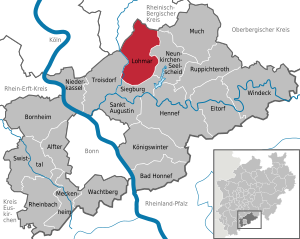
| Location of the city of Lohmar in the Rhein-Sieg district | ||
  |
||

Lohmar is a town in the Rhein-Sieg district in the southern part of the Bergisches Land on the Agger River . Originally the name apparently comes from Frankish immigrants; In their language, Loh stands for forest and Mar for stagnant water or a swamp .
geography
Neighboring communities
The city of Lohmar borders the following cities and communities: Overath , Rösrath (both Rheinisch-Bergischer Kreis ), Neunkirchen-Seelscheid , Siegburg , Troisdorf (all Rhein-Sieg-Kreis).
City structure
The current city of Lohmar was formed by the municipality reform in 1969 from the previously independent municipalities of Lohmar, Breidt , Halberg , Inger and Scheiderhöhe of the Lohmar office and the non-official municipality of Wahlscheid . The Lohmar urban area is divided into 30 districts with around 108 associated hamlets and farms .
Districts

Agger , Albach , Algert , Birk , Breidt , Dahlhaus , Deesem , Donrath , Durbusch , Ellhausen , Geber , Grimberg , Hausen , Heide , Heppenberg , Höffen , Honrath , Hove , Hoven , Inger , Krahwinkel , Lohmar, Muchensiefen , Neuhonrath , Oberstehöhe , Scheid , Scheiderhöhe , Wahlscheid , Weegen and Wielpütz .
Housing areas and hamlets
Aggerhütte , Bach , Bachermühle , Bich , Birken , Bloch , Bombach , Breideneichen , Büchel (near Naaf) , Dachskuhl , Emmersbach , Feienberg , Fuchsfarm , Gammersbach , Grünagger , Grünenborn , Hähngen , Halberg , Hammerschbüchel , Hausdorp , Heide (near Höffen) , Höfferhof , Hohn , Hohnenberg , Holl , Höngesberg , Honsbach , Ingersauel , Jexmühle , Jüchen , Kattwinkel , Kellershohn , Kern , Kirchbach , Klasberg , Klefhaus , Klein-Bombach , Kleinhecken , Knipscherhof , Kreuzhäuschen , Kreuznaaf , Kuckenbach , Mackenbach , Mailahn , Meigermühle , naaf , Naaferberg , Naafshäuschen , Neuheim , Oberscheid , Oberschönenbuch Rath , Oberstesiefen , Peisel , Pützrath , Reelsiefen , Rodderhof , Rottgen , hall , Salgert , Schiefelbusch , Schlehecken , Schoenberg , Schiffarth , Sottenbach , Specht Berg , sticks , Proud Bach , Stumpf , Ungertz , sub Dahl house , Unterstesiefen , Weeg , Weilerhohn , Wickuhl , Winkel
Yards
Alfen Hard , broom Grevenbroich , Birkhof , Grevenbroich , Bruckerhof , fish Burg , pit pilot , Hagen , Hagerhof , Hitzhof , Höhnchen , Höngen , Hoverhof , Ingerhof , Catherine Bach , Kirch Scheid , Krölenbroich , Lohmarhohn , Meigerhof , My Grevenbroich , Neuenhof , Rosauel , Scherferhof , Schöpcherhof , Windlöck
Mills
Breidtersteegsmühle , Dorpmühle , Gammersbacher Mühle , Gebermühle , Helmgesmühle , Honsbachermühle , Naafer Mühle
Waters
The largest flowing body of water is the Agger . In the Lohmar city area, some bridges lead over the Agger, which are popular with tourists as a photo motif or starting point.
history
Lohmar is mentioned for the first time in a donation from Archbishop Sigewin to the Georgstift in Cologne , which is estimated to be in the year 1081. It mentions a farm in Lomere . Politically, Lohmar belonged to the Blankenberg office in the Duchy of Berg .
Napoleon stayed in Auel Castle near Wahlscheid during an inspection by the Rhine Army in 1811 ; it was his only visit to the Rhineland. On August 1, 1969, the municipalities of the offices of Lohmar and Wahlscheid were merged to form the new municipality of Lohmar. Lohmar has had city rights since 1991.
In the area of the city of Lohmar, numerous smaller ore deposits are set up, which in the past were repeatedly mined over short periods of time. They last delivered a few hundred tons of copper, lead and zinc ores in the middle of the 19th and early 20th centuries. The Walpot mine near Deesem in the Lessbachtal has been proven to have been in operation before the Thirty Years War (mining of copper pebbles). Larger mines were located at Lohmarhohn (Moritz pit), Salgert (Nöggerath pit), Wahlscheid ( Pilot pit ), Bloch im Naafbachtal (Schubert pit), Aggerhütte (pit field Grubenkittel) and Honrath (Aurora and Volta pits). As part of an archaeological excavation, the tunnel mouth hole of the Walpot pit in the Niedersachsen valley was opened and examined in 1995. One found a tunnel excavated with mallets and iron work, which had been made before the use of blasting technology in mining (dating: early modern times).
| Population development | ||||||||||||||||||||||||||||||||||||||||||||||||||||||||||||||||||||||||||||||||||||||||||||||||||
|---|---|---|---|---|---|---|---|---|---|---|---|---|---|---|---|---|---|---|---|---|---|---|---|---|---|---|---|---|---|---|---|---|---|---|---|---|---|---|---|---|---|---|---|---|---|---|---|---|---|---|---|---|---|---|---|---|---|---|---|---|---|---|---|---|---|---|---|---|---|---|---|---|---|---|---|---|---|---|---|---|---|---|---|---|---|---|---|---|---|---|---|---|---|---|---|---|---|---|
| Year * | 1962 | 1970 | 1980 | 1990 | 2000 | 2002 | 2004 | 2006 | 2008 | 2010 | 2011 | 2017 | ||||||||||||||||||||||||||||||||||||||||||||||||||||||||||||||||||||||||||||||||||||||
| Residents | 11,384 | 18,853 | 23,496 | 27,098 | 30,659 | 31,218 | 31,175 | 31,247 | 31.198 | 31,129 | 31,272 | 30,451 | ||||||||||||||||||||||||||||||||||||||||||||||||||||||||||||||||||||||||||||||||||||||
* as of December 31st
politics
City council
The city council is the municipal representative of the people of the city of Lohmar. The citizens decide on the composition every five years. The last election took place on May 25, 2014.
mayor
Horst Krybus (CDU) has been mayor since 2014 . He was directly elected as the successor to Wolfgang Röger (CDU) in the local elections on May 25, 2014 with 50.1% of the valid votes .
coat of arms
The coat of arms shows the Bergische Löwen in its upper part (Lohmar used to belong to the Duchy of Berg ) and in the lower part the confluence of the Agger and Sülz rivers .

Visual appearance - Lohmar in public
In early 2003, Lohmar introduced a new visual appearance . The aim is to present the city to the public in a uniform and distinctive way. The most important aspect is the new logo, which is placed in a prominent position in all communication media and measures. In addition, it acts as a trademark for the city administration and its services.
“The black font stands for the structures created by people. The green wave stands for the mountainous landscape of the city of Lohmar. The blue wave stands for the confluence of the Agger and Sülz in the Lohmar city area. "
Town twinning
Lohmar has been twinned with Frouard and Pompey in France since 1974 , with Vila Verde in Portugal since 1986 , with Eppendorf in Saxony since 1990 and with Żarów in Poland since 2007 .
Culture and sights

music
The city of Lohmar operates the Lohmar Music and Art School , which has achieved considerable success up to the federal level and has produced several artists and projects that are now internationally active themselves. The music and art school gives almost 800 children, young people and adults qualified music and art lessons. In particular, the guitar forum, which is held every two years, causes a stir again and again. The music and art school is an essential part of the Lohmar cultural landscape. There are many choirs and orchestras, some of which are ecclesiastical.
Castles and Palaces
Libraries
The Lohmar City Library has around 40,000 media units, such as books, magazines, newspapers, CD-ROMs, computer games, CDs, audio books, cassettes, DVDs and conventional games. Four internet workstations are available in the Lohmar City Library and the Wahlscheid City Library. With 50,000 visitors in 2010, the city library is the most visited cultural institution in the city. An average of five media are borrowed per citizen.
Parks, green spaces and forests
In the city center there are hardly any green spaces except for the park at Villa Friedlinde. The periphery is very green due to the village structure. The Naafbachtal is under nature protection because of its flora and fauna , other distinctive green areas are the Siegburger Staatsforst or the former restricted area of the Wahner Heide, which is also under nature protection . The landscape garden Aggerbogen is located in the Wahlscheid district . The Deutsche Alleenstrasse runs through the city of Lohmar . An avenue with three rows of trees can be found between Lohmar-Donrath and Rösrath-Rambrücken.
Sporting events
In the city of Lohmar there are golf courses at Schloss Auel (Wahlscheid) and Naafshäuschen (Agger). The international bike race “Around Cologne-Bonn Airport ” has been running through Lohmar for years with sprint ratings on the main street.
Economy and Infrastructure
Kindergartens
There are five communal kindergartens in Lohmar (sponsored by the city of Lohmar), eight denominational kindergartens (four Protestant, four Catholic), including an integrative kindergarten operated by the Protestant Church in Wahlscheid and three others sponsored by the workers ' welfare organization and parents' initiatives.
schools
Elementary schools
- Community elementary school Birk (open all-day school)
- Donrath Community Primary School (open all-day school)
- Community elementary school Waldschule Lohmar (open all-day school, with teaching pool)
- Community elementary school Wahlscheid (open all-day school)
further training
- Lohmar high school
- Lohmar comprehensive school
The Lohmar grammar school, which went into operation in 1991, and partly also the comprehensive school are located in the Donrather Dreieck educational campus. In addition to two sports fields, an artificial turf field and the grass field in the stadium, there is also the Jabachhalle, which is used for physical education, but also serves for cultural events. Since 2016, students have been able to have lunch in a newly built cafeteria. The first location of the comprehensive school is the former secondary school complex in the Donrather Dreieck, the second location is in the premises of the former community secondary school in Hermann-Löns-Straße.
other schools outside of compulsory education
- Music and Art School Lohmar
- Aggerbogen Nature School (in Lohmar-Wahlscheid)
- Adult education center in the Rhein-Sieg-Kreis-Zweckverband
Established businesses
The urban area is mainly characterized by agriculture and forestry . Industry settled relatively late by the proximity to the motorway A 3 at. Mainly companies from the metal processing , electrical and plastics processing industries are represented, including GKN Walterscheid GmbH and Emitec . Lohmar-Scheiderhöhe is also the founding place and until 2011 the head office of the ABS Pumps group , one of the largest manufacturers of pumps and agitators . ABS Pumps was renamed Cardo Flow Solutions Germany GmbH in 2010 , was transferred to the Swiss Sulzer Group in 2011 and then closed at the end of 2017.
In recent years the city center has developed through various new buildings and renovations. The “Lohmarer Höfe” office and shopping center, which opened at the end of 2008, made a major contribution to this development and made Lohmar more attractive to retailers. Today, many shops, such as the chain stores KiK and Rossmann , the Oebel bakery and the Chronoline jeweler, are represented on site. On November 17, 2011, the Kaufland opened at the new location and creates a further enrichment for the local economy. In the future, more companies will settle here and continue the economic expansion.
telecommunications
The 134-meter-high Lohmar-Birk telecommunications tower belonging to Deutsche Telekom AG is in the Birk district .
media
The most important radio station for Lohmar is Radio Bonn / Rhein-Sieg , the local radio for Bonn and all cities and municipalities in the Rhein-Sieg district. The most important print media as daily newspapers are the Kölner Stadt-Anzeiger with the local edition as Rhein-Sieg-Anzeiger and the Kölnische Rundschau with the local edition as the Rhein-Sieg-Rundschau as well as the monthly newspaper Lohmarer Stadtanzeiger. The weekly print medium is the city echo.
traffic

Rail and bus transport
In the local rail passenger traffic , Lohmar is connected to the Aggertalbahn from Cologne via Overath and Gummersbach to Meinerzhagen via the Honrath stop , on which the Oberbergische Bahn (RB 25) runs to Cologne and Meinerzhagen.
There used to be a Lohmar inner city train station on the Siegburg – Olpe railway line , which originally ran from Siegburg via Lohmar and Overath to Gummersbach , although passenger traffic was discontinued here in 1956. Until the end of the 1980s there was still freight traffic between Siegburg and Lohmar. The Lohmar-Overath section has been dismantled since the 1960s. Today the Siegburg Bahnhof – Siegwerk section is still used by freight trains. The rest of the Siegburg-Lohmar route was or will be converted into a cycle path. On the "forest route" between Siegburg and Lohmar there are still the tracks that are now overgrown.
In road passenger transport operate in the transport association Rhein-Sieg (VRS) numerous bus routes, mainly between Siegburg , Rösrath and Overath. After the exempted school traffic was discontinued, there are now bus connections for the general public for the villages on the Lohmar mountain ridge; But because the buses rarely go to these places and mainly continue to serve school traffic, there is also a shared call taxi (AST) .
Bicycle traffic
In particular, the axis through the Aggertal (Siegburg - Lohmar - Wahlscheid - Overath) along the B 484 is well developed thanks to developed cycle paths. The mountain ridges and the axis through the Jabachtal along the B507 are not equipped with cycle paths. The city of Lohmar is currently (as at the end of 2007) developing a bicycle traffic concept for the systematic improvement of the bicycle traffic infrastructure.
Streets
Lohmar is two-fold to the A3 tethered. While the Lohmar junction (31) allows traffic in both directions, as usual, the Lohmar-Nord junction (30b) is a semi-solution that only allows traffic to and from Frankfurt. The counterpart to this half-solution can be found at the next junction, Rösrath (30) ( Scharrenbroich ), which takes traffic to and from Cologne.
On January 1, 2018, 24,017 motor vehicles were registered in the municipality, including 20,152 cars.
Personalities
sons and daughters of the town
- Horst Becker (* 1956), member of the NRW state parliament of the Greens
- Johann Gregor Breuer (1820 or 1821–1897), teacher and pastor, founder of the first journeymen's association in Elberfeld (1846) and pioneer of the Kolping Society
- Max Hoff (* 1982), canoeist
- Johannes Philipp Höver (1816–1864), founder of the Order of the Poor Brothers of St. Francis in 1857 in Aachen
- Michael Kohtes (* 1959), writer and journalist
- Berta Lungstras (1836–1904), founder of the first Protestant women's shelter in Bonn in 1873
- Albert and Maria Meier, resistance fighters and "Righteous Among the Nations"
- Käthe Overath (1926–1995), resistance fighter during the Nazi era , "Righteous Among the Nations"
- Ludwig and Elisabeth Weeg, married couple and "Righteous Among the Nations"
- Dietmar Schott (* around 1938), long-time sports director of WDR radio
- Anna Klink (* 1995), national youth soccer player
Honorary citizen
- Hermann Oberheuser, Mayor
- Wilhelm Schultes, Mayor
- Wilhelm Schulte, Mayor
- Kurt Stremlau, local politician
- Bernhard Walterscheid-Müller, entrepreneur and local researcher
- Hans Günther van Allen (* 1934), Mayor
People associated with the city
- Karlheinz Bräuer (1924–2007), member of the NRW state parliament of the SPD and district chairman of IG Metall Cologne
- Randi Crott (* 1951 in Wuppertal), German journalist, lives in Dahlhaus
- Hermann-Josef Frisch (* 1947), non-fiction author and Roman Catholic priest, lived in Lohmar until 2012
- John Goldsby (* 1958), American jazz musician, has lived with his family in Lohmar since 1994
- Otto Günsch (1917–2003) was SS-Sturmbannführer and personal adjutant to Adolf Hitler
- Marcel Kommissin (* 1979), German-Peruvian actor
- Paul Schäfer (1921–2010), founder of the former Colonia Dignidad in Chile, founded the “Private Social Mission” in Lohmar-Heide in 1956, a home for children of group members of his free church community, see P. Schäfer “Projects in Germany” .
- Manfred Schoof (* 1936), jazz trumpeter, lives in Lohmar
- Sylvia Vrethammar (* 1945), pop singer, lives in Honrath
- Jupp Elze (1939–1968), German professional boxer, lived in Birken
Individual evidence
- ↑ Population of the municipalities of North Rhine-Westphalia on December 31, 2019 - update of the population based on the census of May 9, 2011. State Office for Information and Technology North Rhine-Westphalia (IT.NRW), accessed on June 17, 2020 . ( Help on this )
- ↑ Topographic map 1: 250000
- ^ Law on the local reorganization of the Bonn area (Bonn Law) of July 1, 1969; § 13
- ^ City of Lohmar :: Localities. Retrieved August 15, 2019 .
- ^ City of Lohmar - localities. City of Lohmar, accessed April 26, 2019 .
- ^ Topographic map 1: 25000
- ↑ Reference of Napoleon's overnight stay in Auel Castle at www.schlossauel.de
- ↑ Martin Bünermann: The communities of the first reorganization program in North Rhine-Westphalia . Deutscher Gemeindeverlag, Cologne 1970, p. 84 .
- ^ Albert Seemann: Metal ore mining in the lower Aggertal . Self-published, Lohmar 1990.
- ↑ Michael Gechter and Albert Seemann: Stollen, Schlägel, Schächte - Mining archeology in the Kleinesbach Valley . Ed .: City of Lohmar and Heimat- und Kulturverein Breidt e. V. Breidt 1995.
- ↑ Lohmar. Council election - overall result. May 25, 2014, accessed October 27, 2014 .
- ↑ http://www.naturschule-aggerbogen.de/
- ↑ a b http://www.lohmar.de/
- ↑ http://www.lohmar.info/b038.html
- ↑ http://www.innovationsstandort-lohmar.de/
- ↑ Mobility in North Rhine-Westphalia - data and facts 2018/2019. In: Road traffic. Ministry of Building, Housing, Urban Development and Transport of the State of North Rhine-Westphalia, p. 66 (PDF; 14.2 MB, holdings on January 1, 2018).
- ^ Rhein-Sieg-Rundschau v. June 11, 2015, p. 33, Tillmann Becker-Wahl: Wahlscheids world champion
- ↑ County town honors Randi Crott. In: Rhein-Sieg-Rundschau. October 7, 2014
- ↑ 50 years ago: Boxer woman doesn't want a monkey . In: Rhein-Sieg-Rundschau . 5th September 2016.
Web links
Alfter | Bad Honnef | Bornheim | Eitorf | Hennef (victory) | Koenigswinter | Lohmar | Meckenheim | Much | Neunkirchen-Seelscheid | Niederkassel | Rheinbach | Ruppichteroth | Saint Augustine | Siegburg | Swisttal | Troisdorf | Wachtberg | Windeck
Districts of
Agger |
Albach |
Algert |
Birk |
Breidt |
Dahlhaus |
Deesem |
Donrath |
Durbusch |
Ellhausen |
Encoder |
Grimberg |
Hausen |
Heather |
Heppenberg |
Höffen |
Honrath |
Hove |
Hoven |
Inger |
Krahwinkel |
Lohmar |
Muchensiefen |
Münchhof |
Neuhonrath |
Top height |
Scheid |
Scheiderhöhe |
Election decision |
Ways |
Wielpütz
districts and residential areas
Aggerhütte |
Alfenhard |
Bach |
Bachermühle |
Besenbroich |
Bich |
Birch trees |
Birkhof |
Bloch |
Bombach |
Broad oaks |
Breidtersteegsmühle |
Broich |
Brückerhof |
Büchel |
Dachskuhl |
Dorpmühle |
Oak trees |
Emmersbach |
Feienberg |
Fischburg |
Fox farm |
Gammersbach |
Gammersbacher Mill |
Gebermühle |
Pit pilot |
Green excavator |
Grünenborn |
Hagen |
Hagerhof |
Roosters |
Halberg |
Hammerschbüchel |
Hausdorp |
Heide (near Höffen) |
Helmgesmühle |
Hitzhof |
Höfferhof |
Scorn |
Hohnenberg |
Croissant |
Holl |
Höngen |
Höngesberg |
Honsbach |
Honsbacher Mill |
Hoverhof |
Ingerhof |
Ingersauel |
Jexmühle |
Juchen |
Katharinenbach |
Kattwinkel |
Basement mockery |
Core |
Kirchbach |
Kirchscheid |
Klasberg |
Klefhaus |
Klein-Bombach |
Small hedges |
Knipscherhof |
Crosshouses |
Kreuznaaf |
Krölenbroich |
Kuckenbach |
Wages |
Mackenbach |
Mailahn |
Meigerhof |
Meigermühle |
Meinenbroich |
Naaf |
Naaferberg |
Naafmühle |
Naafshäuschen |
Neuenhof |
Neuheim |
Oberscheid |
Oberschönrath |
Oberstesiefen |
Peisel |
Pützrath |
Reelsiefen |
Rodderhof |
Rosauel |
Röttgen |
Hall |
Salgert |
Scherferhof |
Boot bush |
Schlehecken |
Schönenberg |
Schöpcherhof |
Schiffarth |
Sottenbach |
Spechtsberg |
Sticks |
Stolzenbach |
Stump |
Ungertz |
Unterdahlhaus |
Unterstesiefen |
Weeg |
Hamlet mockery |
Wickuhl |
Windlöck |
angle