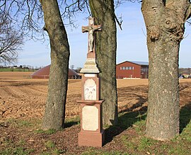
Schöpcherhof
|
Schöpcherhof
City of Lohmar
Coordinates: 50 ° 52 ′ 34 ″ N , 7 ° 13 ′ 56 ″ E
|
||
|---|---|---|
| Height : | approx. 160 m above sea level NHN | |
| Incorporation : | 1st August 1969 | |
| Postal code : | 53797 | |
| Area code : | 02206 | |
|
Location of Schöpcherhof in North Rhine-Westphalia |
||
Schöpcherhof is a residential area consisting of a single courtyard that belongs to the town of Lohmar in the Rhein-Sieg district in North Rhine-Westphalia .
geography
Schöpcherhof is located in the northwest of Lohmar. Surrounding villages and hamlets are Oberscheid in the north, Schiffarth , Brückerhof , Hitzhof and Wahlscheid in the northeast, Mackenbach and Dorpmühle in the east, Stolzenbach , Peisel , Hausen , Höngesberg , Hammerschbüchel and Reelsiefen in the southeast, Scheiderhöhe in the south and southwest, Hoverhof in the west and Klasberg , Hagerhof and Muchensiefen in the northwest.
A nameless orographically right tributary of the Agger rises northeast of Schöpcherhof .
history
In 1885 the Schöpcherhof had a house with twelve residents.
Until 1969, Schöpcherhof belonged to the previously independent community of Scheiderhöhe .
Worth seeing
There is a crossroads on the district road in front of the Schöpfcherhof biogas plant. The inscription reads: “This cross was erected in the highest honor of Jesus Mary and Joseph and his bitter suffering and death of our crucified Savior and Redeemer Jesus Christ. Theodor Ölligsschläger and Anna Catharina Kuttenkeuler. 1807 "
traffic
Schöpcherhof is to the east of Landesstraße 84.
Individual evidence
- ↑ a b Topographic map 1: 25,000
- ^ Community encyclopedia for the Kingdom of Prussia from 1885
- ↑ Gerd Streichardt: When stones speak - wayside crosses in Lohmar . Ratio-Books, Lohmar 2011, ISBN 978-3-939829-23-2 , pp. 57-58 .
- ↑ Lohmar NATURally. An annual walk through our rural town. Hermann Wenzel, Lohmar-Wahlscheid, accessed on September 11, 2015 (pictures and location of the wayside cross).


