Muchensiefen
|
Muchensiefen
City of Lohmar
Coordinates: 50 ° 52 ′ 57 ″ N , 7 ° 13 ′ 30 ″ E
|
||
|---|---|---|
| Height : | approx. 160 m above sea level NHN | |
| Incorporation : | 1st August 1969 | |
| Postal code : | 53797 | |
| Area code : | 02205 | |
|
Location of Muchensiefen in North Rhine-Westphalia |
||
|
Half-timbered house (Am Schlagbaum 2)
|
||
Muchensiefen is a district of Lohmar in the Rhein-Sieg district in North Rhine-Westphalia .
geography
Muchensiefen is in the west of Lohmar. Surrounding hamlets and towns are Dachskuhl in the north, Neuenhof and Spechtsberg in the northeast, Oberscheid and Schiffarth in the east, Schöpcherhof and Scheiderhöhe in the southeast, Hagerhof , Klasberg and Hoverhof in the south, Kellershohn and Gammersbacher Mühle in the southwest, Rodderhof in the west, and Oberschönrath and Schönrath Castle in the north-west.
The Gammersbach , an orographically left tributary of the Sülz , flows along Muchensiefen. A nameless tributary of the Gammersbach rises in Muchensiefen and flows to it from the left bank.
landscape
Muchensiefen is characterized by agriculture. Many meadows and forests define the townscape.
history
In 1885 Muchensiefen had twelve houses and 38 residents.
Until August 1, 1969, the place belonged to the previously independent community Scheiderhöhe .
Attractions
- The listed Gammersbacher Mühle southwest of Muchensiefen
- The Gammersbach with its wetlands
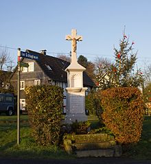
- There is a crossroads at the Schönau / Am Schlagbaum intersection. It bears the inscription: “Salvation is in the cross! - Erected by Ww. Jos. Linden zu Muchensiefen in 1885. - Crucified Savior have mercy on the dead. "
traffic
- Muchensiefen is close to Landesstraße 84.
- Nearby train stations are in Lohmar- Honrath near Jexmühle and in Rösrath .
- Muchensiefen belongs to the tariff area of the Verkehrsverbund Rhein-Sieg (VRS).
- The following hiking trails lead through Muchensiefen: Bergischer Streifzug No. 18 "Farm Trail", the "Kölner Weg" of the Westerwaldverein and the hiking trail "<3" of the Cologne Eifelverein.
Individual evidence
- ↑ a b c Topographic map 1: 25000
- ^ Community encyclopedia for the Kingdom of Prussia from 1885
- ^ Law on the local reorganization of the Bonn area (Bonn Law) of July 1, 1969; § 13
- ↑ Gerd Streichardt: "When stones talk - wayside crosses in Lohmar" page 63 at ratio-books.de ( memento of the original from March 5, 2016 in the Internet Archive ) Info: The archive link was inserted automatically and not yet checked. Please check the original and archive link according to the instructions and then remove this notice.
- ↑ Pictures of the wayside cross at wenzel-wahlscheid.de
- ↑ Bergischer Streifzug No. 18 / Bauernhofweg at bergisches-wanderland.de
- ↑ Kölner Weg of the Westerwaldverein under ich-geh-wandern.de
- ↑ Hiking trails of the Cologne Eifelverein at koelner-eifelverein.de


