Höffen (Lohmar)
|
Hofen
City of Lohmar
Coordinates: 50 ° 53 ′ 14 " N , 7 ° 16 ′ 26" E
|
||
|---|---|---|
| Height : | 194 m above sea level NHN | |
| Postal code : | 53797 | |
| Area code : | 02206 | |
|
Location of Höffen in North Rhine-Westphalia |
||
Höffen is a district of Lohmar in the Rhein-Sieg district in North Rhine-Westphalia .
geography
Höffen is located in the northeastern part of the urban area of Lohmar, orographically left to the Aggertal near Wahlscheid . Surrounding villages and hamlets are Neuhonrath in the north, Grünenborn , Oberstehöhe and Saal in the northeast, Heide , Ingersauel and Naaf in the east, Büchel , Naafmühle and Bloch in the southeast, Mailahn and Weeg in the south and Münchhof , Wahlscheid, Hohn , Schönenberg and Klefhaus in the west to the northwest.
One of the two source rivers of the Hohner Bach rises in Kattwinkel near Höffen , which finally flows into the Agger near Wahlscheid as a left tributary . For R. Naafbach towards spring some unnamed source rivers.
history
In 1885 the village of Höffen had 15 inhabitants who lived in four houses.
According to an address book from 1901, the place had 23 residents; among them were three farmers , a landlord , baker and grocer , and a carpenter .
Until August 1, 1969, the place belonged to the previously independent municipality Wahlscheid .
Sights / hiking trails
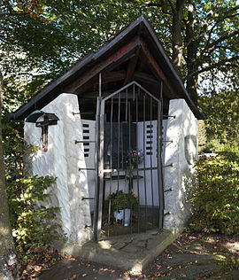
A small chapel / holy house in honor of the patron saint of the hunters, a Hubertus chapel, is somewhat hidden in the street “Am Rothfeld”. It was built in 1952 by the Münks family from Cologne, who owned a hunting lodge in Höffen as early as the 1930s.
Höffen can be used as a starting point for hikes to the Naafbachtal , a nationally known nature reserve .
The circular hiking trails A1 and A2 of the Sauerland Mountain Association (SGV) start in Höffen (hiking car park at the restaurant "Auf dem Berge").
regional customs
Traditionally, people from Höffen and the surrounding area take part in the fair parade of the Wahlscheider fair .
traffic
- Höffen is located directly on Kreisstraße 34 , the main road near Höffen.
- The nearest train station in Jexmühle is Lohmar- Honrath train station .
- Bus traffic in Höffen is very rare. This is why the shared call taxi (AST) supplements public transport . Höffen belongs to the tariff area of the Verkehrsverbund Rhein-Sieg (VRS).
Individual evidence
- ↑ City portrait, Lohmar in brief ( Memento of the original dated February 2, 2012 in the Internet Archive ) Info: The archive link was inserted automatically and has not yet been checked. Please check the original and archive link according to the instructions and then remove this notice. on the homepage of the city of Lohmar
- ↑ a b Topographic map 1: 25,000
- ^ Community encyclopedia for the province of Rhineland (PDF; 1.5 MB), Verlag des Königlich Statistischen Bureaus, 1888, p. 120
- ↑ Large country address book for the individual states and provinces of the German Empire. Berenberg, Hannover 1901, p. 224
- ^ Law on the local reorganization of the Bonn area (Bonn Law) of July 1, 1969; § 13
- ↑ Gerd Streichardt: When stones talk - wayside crosses in Lohmar, page 135 at ratio-books.de ( memento of the original from March 5, 2016 in the Internet Archive ) Info: The archive link was automatically inserted and not yet checked. Please check the original and archive link according to the instructions and then remove this notice.
- ↑ Sauerland Mountain Association circular hiking trail A1 from Höffen at sgv-bergischesland.de
- ↑ Sauerland Mountain Association circular hiking trail A2 from Höffen at sgv-bergischesland.de


