
List of locks in the Saale
The list of locks in the Saale includes all the existing and incomplete locks along the river and in the canal-like branches that carry water from the river, which are artificially created to improve navigation or for hydrological reasons. In 1926, as part of the planning for the Mittelland Canal south wing to the waterway connection from Leipzig , the Reich government decided to expand the Saale for 1000-tonne ships. This happened from 1933 until the Second World War from the mouth at Barby to Halle . An expansion above Halle was no longer planned since the end of the Second World War .
The Saale is a river in Bavaria , Thuringia and Saxony-Anhalt . With a length of 413 kilometers, it is the second longest tributary of the Elbe after the Vltava . Since October 3, 1990, the Saale has been a federal waterway from km 0.0 to 124.40 and is looked after by the Federal Waterways and Shipping Administration ( Wasserstraßen- und Schifffahrtsamt Magdeburg ). Since July 1, 2010, the locks have been remotely controlled via the Bernburg Revierzentrale and are no longer manned. From the pipe bridge Leuna-Kröllwitz (Saale-Km 124.40) the river is Landeswasserstraße. The State Office for Flood Protection and Water Management Saxony-Anhalt is responsible. The locks in the upper reaches of the river are either self-service locks or can be operated on site after prior notification by telephone.
Large locks of the Saale
| place | Name of the lock | Kilometers of waterways | Dimensions (chamber length / gate width / chamber width / drop height) | Open to traffic / year of construction / renovation | image | Call channel / phone | Coordinates |
|---|---|---|---|---|---|---|---|
|
|
|||||||
| Calbe , | Calbe lock | Sl 20.00 | L 105.00 m / W 12.00 m / W 20.00 m / fall height 3.46 m | 1934/41 | .jpg) |
You can register for the smuggling by phone on 03471 34664081 or VHF 20 | 51 ° 54 ′ 12 ″ N, 11 ° 47 ′ 21 ″ E |
| Bernburg | Bernburg lock | Sl 36.10 | L 103 m / W 12 m / W 20.00 m / fall height 3.28 m | 1934/38 |  |
You can register for the smuggling by phone on 03471 34664081 or VHF 60 | 51 ° 47 ′ 47 "N, 11 ° 44 ′ 5" E |
| Alsleben | Alsleben lock | Sl 50.30 | L 103 m / W 12 m / W 20.00 m / drop height 4.07 m | 1937/39 |  |
You can register for the smuggling by telephone on 03471 34664081/82 or UKW 61 | 51 ° 42 ′ 25 "N, 11 ° 40 ′ 42" E |
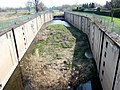
| Rothenburg | Rothenburg lock | Sl 58.70 | L 103 m / W 12 m / W 20.00 m / fall height 3.07 m | 1938/42 | _001,_Schleuse_Rothenburg.jpg) |
Registration for the smuggling takes place by phone on 03471 34664081/82 or VHF 62 | 51 ° 39 ′ 17 ″ N, 11 ° 45 ′ 7 ″ E |
| Wettin | Wettin lock | Sl 70.40 | L 103.00 m / W 12.00 m / W 20.00 m / drop height 2.51 m | 1938, construction halt in 1942/43, construction continued at the end of the 1940s |  |
Registration for the smuggling takes place by phone on 03471 34664081/82 or UKW 21 | 51 ° 34 '56 "N, 11 ° 47' 39" E |
Saale locks WSA suburb 5, Halle (Saale) / Merseburg
| place | Name of the lock | Kilometers of waterways | Dimensions (chamber length / gate width / chamber width / drop height) | Open to traffic / year of construction / renovation / conversion | image | phone | Coordinates |
|---|---|---|---|---|---|---|---|
|
|
|||||||
| Trotha (hall) | Halle-Trotha lock | Sl 89.20 | L 52.89 m / W 6.12 m / W 6.12 m / fall height 2.41 m | 1873/74 |  |
You can register for the smuggling by phone on +49 345 5201787 | 51 ° 30 ′ 50 "N, 11 ° 57 ′ 17" E |
| Halle (Saale) | Gimritz lock | Sl 92.60 | L 51.00 m / W 6.11 m / W 6.11 m / fall height 0.98 m | 1696/1762/1852 |  |
You can register for the smuggling by phone on +49 345 2901651 | 51 ° 29 ′ 19 ″ N, 11 ° 57 ′ 20 ″ E |
| Halle (Saale) | Halle-Stadt lock | Sl 93.60 | L m / W m / W m / height of fall 0.98 m | 1835 |  |
Registration for the smuggling takes place by phone on +49 345 2383716 | 51 ° 28 ′ 50 "N, 11 ° 57 ′ 37" E |
| Halle (Saale) | Böllberg lock | Sl 95.80 | L 47.29 m / W 5.60 m / W 5.60 m / fall height 1.35 m | 1817-1820 |  |
You can register for the smuggling by phone on +49 345 441056 | 51 ° 27 '49 "N, 11 ° 56" 48 "E |
| Halle (Saale) , | Planena lock | Sl 104.40 | L 47.20 m / W 5.65 m / W 5.65 m / fall height 2.33 m | 1820 |  |
Registration for the smuggling takes place by phone on +49 3461 331611 | 51 ° 24 ′ 58 "N, 11 ° 57 ′ 17" E |
| Merseburg , | Lock Merseburg-Meuschau | Sl 113.50 | L 47.46 m / W 6.00 m / W 5.60 m / fall height 2.77 m | 1820 |  |
Registration for the smuggling takes place by phone on +49 3461 331611 | 51 ° 21 ′ 36 "N, 12 ° 0 ′ 14" E |
| Merseburg | Rischmühlen lock | Sl 115.20 | L 47.50 m / W 5.95 m / W 5.60 m / fall height 2.33 m | 1820 |  |
You can register for the smuggling by phone on +49 3461 211216 | 51 ° 21 ′ 1 ″ N, 12 ° 0 ′ 10 ″ E |
Landeswasserstraße
| place | Name of the lock | Kilometers of waterways | Dimensions (chamber length / gate width / chamber width / drop height) | Open to traffic / year of construction / renovation / conversion | image | phone | Coordinates |
|---|---|---|---|---|---|---|---|
|
|
|||||||
| Bad Dürrenberg , | Bad Dürrenberg lock | Sl 126.20 | L approx. 47 m / W 5.50 m / W 5.50 m / fall height? m | 1822, remodeling 1882/83 |  |
You can register for the smuggling by phone on +49 3462 80530 | 51 ° 17 ′ 41 ″ N, 12 ° 3 ′ 35 ″ E |
| Weissenfels | Herrenmühlenschleuse | Sl 141.10 | L approx. 47.00 m / W 5.50 m / W 5.50 m / fall height? m | 1821/23, renovation 1991 |  |
You can register for the smuggling by phone on +49 3443 341491 | 51 ° 12 ′ 20 "N, 11 ° 58 ′ 40" E |
| Weissenfels | Bridge mill lock | Sl 142.50 | L approx. 47.00 m / W 5.50 m / W 7.00 m / height of fall? m | 1821/23, renovation 1991 | You can register for the smuggling by phone on +49 3443 802640 | 51 ° 12 ′ 20 "N, 11 ° 57 ′ 36" E | |
| Weissenfels | Beuditzmühlen lock | Sl 143.20 | L approx. 47.00 m / W 5.50 m / W 8.00 m / fall height? m | 1790 |  |
Registration for the smuggling takes place by phone on +49 3443 307155 | 51 ° 12 ′ 19 ″ N, 11 ° 57 ′ 1 ″ E |
| Schoenburg (Saale) | Oeblitzschleuse | Sl 151.80 | L approx. 47.00 m / W 5.50 m / W 5.50 m / fall height? m | 18th |  |
Registration for the smuggling takes place by phone on +49 3443 200228 | 51 ° 11 ′ 14 "N, 11 ° 52 ′ 15" E |
Hydraulic engineering projects
Three other locks, the Werder lock in the central canal , the Halle lock in the Halle (Saale) bypass channel and the Klein Rosenburg lock in the Saale canal were part of the canal project that was started in 1933 and discontinued in 1943 and aimed at improving navigation on the Saale. This project also included the Saale-Elster Canal , which was to connect the White Elster in Leipzig with the Saale near Leuna and thus connect Leipzig to the North German waterway network via the Saale and Elbe and to the North Sea via Hamburg . The canal was planned for ships with a load capacity of up to 1000 tons, which corresponds roughly to today's inland navigation class IV .
The Werder lock was intended to replace the two Saale locks, Rischmühlen lock and Merseburg-Meuschau lock. The planned head at mean water was 4.20 meters and should summarize the heads of the two old locks. The lock is located in the newly created central canal. The Mittelkanal bypasses the urban area of Merseburg with a length of around 3.3 kilometers.
The Halle lock in the planned bypass channel Halle (Saale) to the west past the city area was intended to replace the Böllberg lock.
The planned canal from the Elbe near Barby to the Saale below the railway bridge in Calbe is called the Saale Canal .
Pictures and cards

Waterways in Merseburg

Werderschleuse 2013
Werderschleuse 2019
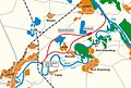
Map of the planned Saale Canal


literature
- Hans-Joachim Uhlemann: Berlin and the Märkische waterways. transpress publishing house for transport, Berlin 1987, ISBN 3-344-00115-9 .
- Western European shipping and port calendar. Binnenschifffahrts-Verlag GmbH. Duisburg-Ruhrort OCLC 48960431
- Martin Eckoldt (Ed.): Rivers and canals. The history of the German waterways. DSV-Verlag Busse Seewald, Hamburg 1998, ISBN 3-88412-243-6 .
cards
- W. Ciesla, H. Czesienski, W. Schlomm, K. Senzel, D. Weidner: Shipping maps of the inland waterways of the German Democratic Republic 1: 10,000. Volume I, editor: Wasserstraßenaufsichtsamt der GDR. Berlin 1988. OCLC 830889996
- Bodo Müller: waterway map Germany northeast. Edition Maritim, Hamburg 2002, ISBN 3-89225-341-2
Web links
Individual evidence
- ↑ Information on the Saale lock WSA Magdeburg , accessed on February 3, 2018.
- ↑ Information on the Saale lock WSA Magdeburg , accessed on February 3, 2018.
- ^ Project Saale-Seiten-Kanal, Wasserstraßen-Neubauamt Magdeburg , accessed on February 3, 2018.