Leutra (Saale, Jena)
| Leutra | ||
|
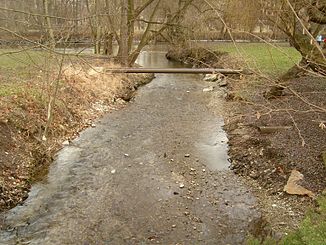
View over the lowest Leutra to its mouth |
||
| Data | ||
| Water code | DE : 56372 | |
| location |
Ilm-Saale-Ohrdrufer plate
|
|
| River system | Elbe | |
| Drain over | Saale → Elbe → North Sea | |
| origin | of the constant run in a fork in the road 0.4 km east-northeast of Großschwabhausen shortly before some clarification ponds 50 ° 56 '27 " N , 11 ° 29" 55 " E |
|
| Source height | approx. 294 m | |
| muzzle | Jena, east of Alexander-Pushkin-Platz Coordinates: 50 ° 55 ′ 21 ″ N , 11 ° 35 ′ 6 ″ E 50 ° 55 ′ 21 ″ N , 11 ° 35 ′ 6 ″ E |
|
| Mouth height | approx. 143 m | |
| Height difference | approx. 151 m | |
| Bottom slope | approx. 19 ‰ | |
| length | approx. 7.8 km | |
| Catchment area | 37.7 km² | |
The Leutra is an almost 8 km long brook in Thuringia , which flows from the left into the middle Saale after initially east-north-east, later east-south-east in the city center of the independent city of Jena .
course
The Leutra emerges in a steady course about 400 meters east-northeast of the outskirts of Großschwabhausen in the district of Weimarer Land at about 294 m in a fork in the road just before some clearing ponds on the left side of the run. A ditch with inconsistent water flow from the village already runs above in the deeply sunk valley basin, the lower part of which, together with a longer ditch, reaches a length of 2.0 km. Its highest point is at 367 m on the edge of the Großschwabhäuser Hain nature reserve.
The Leutra initially flows east-northeast and digs deeper and deeper into the Schwabhäuser Grund . Before it enters the valley forest, it experiences an inflow from the Schlettweiner Born on the right slope . The Weimar – Gera railway descends from start to finish next to the stream into the valley. Immediately after crossing under the B 7 to about 294 m , a shorter northern branch runs along the main road, also called Leutra, which converges in a valley spider about a kilometer further north from three source streams. The united Leutra now flows east-south-east through the Mühltal , accompanied by a railway line and federal road, initially in the forest around the municipal boundary between Großschwabhausen and Jena, then through the open valley floor under forest slopes. At a somewhat offset valley spider, already in the Jena area, streams run from the Rosental from the left and then to the Münchenrodaer Grund from the right, both notch valleys like that of the Leutra itself.
Soon afterwards the brook reaches the settlement boundary of Jena. After the dry valley of Cospedaer Grund has run into from the left, the valley floor widens and flattens out, especially on the left, and the buildings become wider and denser. At Carl-Zeiss-Platz, the Leutra disappears in a hollow under Ernst-Haeckel-Strasse, from which it only emerges again at Erbertstrasse. Now it still crosses under the Saalbahn at the edge to the parks in the Saaletalgrund and then flows from the left and at about 143 m between Rasenmühleninsel and Paradies into the middle Saale , about 200 meters east of Alexander-Puschkin-Platz and a little more southwest of the Paradiesbahnhof .
properties
The Leutra drains a catchment area of almost 38 km², loses about 151 m in height on its 7.8 km long course and therefore has a considerable mean bed gradient of about 19 ‰. Its valley, which cuts through the Ilm-Saale-Ohrdrufer Platte , is notched into the shell limestone .
history
The city of Jena has its origins in this brook, because centuries before the city charter was granted, people settled on the alluvial fan of the Leutrabach. Said settlement was on the outermost border of the so-called Old German People's Area (around 700 AD) and continuously expanded to today's Jena.
Individual evidence
- ↑ a b Height determined with the measurement module on: Online map of the Competence Center Geodata Infrastructure Thuringia (GDI-Th) at the State Office for Surveying and Geoinformation Thuringia ( notes )
- ↑ Length measured on: online map GDI-Th
- ↑ Thuringian State Institute for the Environment (ed.): Area and water code index and map. Jena 1998; 26 pp.
- ^ Rüdiger Stutz on the homepage of the city of Jena
- ^ East German settlement after Walter Kuhn
