
Schwesnitz
| Schwesnitz | ||
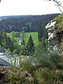
 The Schwesnitz shortly before its confluence with the Saale in Oberkotzau |
||
| Data | ||
| Water code | EN : 5612 | |
| location | District of Hof , Upper Franconia | |
| River system | Elbe | |
| Drain over | Saale → Elbe → North Sea | |
| origin | Confluence of the Perlenbach and Höllbach rivers in Rehau 50 ° 14 ′ 57 ″ N , 12 ° 1 ′ 59 ″ E |
|
| Source height | approx. 520 m above sea level NN | |
| muzzle | in Oberkotzau in the Saale Coordinates: 50 ° 15 ′ 50 " N , 11 ° 55 ′ 56" E 50 ° 15 ′ 50 " N , 11 ° 55 ′ 56" E |
|
| Mouth height | approx. 485 m above sea level NN | |
| Height difference | approx. 35 m | |
| Bottom slope | approx. 1.4 ‰ | |
| length | 25.2 km (including Perlenbach and Lohbach) | |
| Catchment area | 102.6 km² | |
| Discharge at the Rehau A Eo gauge : 84.3 km² Location: 9.2 km above the mouth |
NNQ (02/01/1963) MNQ 1959–2014 MQ 1959–2014 Mq 1959–2014 MHQ 1959–2014 HHQ (06/30/2005) |
40 l / s 168 l / s 678 l / s 8 l / (s km²) 7.01 m³ / s 15.2 m³ / s |
| Small towns | Rehau | |
| Communities | Oberkotzau | |
The Schwesnitz is a right tributary of the Saxon Saale in the Hof district in Upper Franconia .
The name Schwesnitz , in 1470 "Schwirsitz", is derived from the Slavic and Old Sorbian Swistnica or Swisnica and means whistle, whisper or rustle . The Schwesnitz begins in Rehau at the confluence of Perlenbach and Höllbach and flows in a meadow valley - always accompanied by the last section of the Cheb – Oberkotzau railway line - in a westerly direction. It passes the Wurlitz district of Rehau and the Wojaleite nature reserve and finally reaches the Saale in Oberkotzau . The river gave its name to the Schwandewitz settlement, which is now part of Oberkotzau.
Until a few decades ago, the Schwesnitz was heavily polluted by sewage from industrial plants in Rehau (including leather production ), but today it has a good water quality again.
View of the Schwesnitz valley from the Wojaleite

Hiking trail along the Schwesnitz between Wurlitz and Oberkotzau


literature
- Ernst Zeh: Local history of the city of Rehau (...) . 1916. Reprinted by Hof 1987. p. 19.
Individual evidence
- ↑ a b Complete table of the Bavarian water directory of the Bavarian State Office for the Environment (XLS, 10.3 MB)
- ^ German Hydrological Yearbook Elbe Region, Part I 2014. (PDF) State Office for Flood Protection and Water Management Saxony-Anhalt, p. 160 , accessed on November 3, 2018 (from: lhw.sachsen-anhalt.de).
- ^ Zeh, p. 19.