Saalequelle
| Saalequelle | |||
|---|---|---|---|
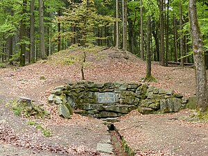
 Edging of the official source of the Saale, until 1869 the mouth of a mine tunnel |
|||
| location | |||
| Country or region | District of Hof , Upper Franconia ( Bavaria ) | ||
| Coordinates | 50 ° 7 ′ 8 " N , 11 ° 49 ′ 42" E | ||
| height | 707 m above sea level NHN | ||
|
|||
| geology | |||
| Mountains | Fichtel Mountains | ||
| Hydrology | |||
| River system | Elbe | ||
| Receiving waters | Saale → Elbe → North Sea | ||
Coordinates: 50 ° 7 ′ 8 ″ N , 11 ° 49 ′ 42 ″ E
The Saalequelle is the origin of the Saale , a tributary of the Elbe and one of the four more important Central European rivers (Saale, Eger , Naab and Main ), which arise in the Fichtelgebirge .
It is located at the foot of the Großer Waldstein on the northwestern edge of the Fichtelgebirge, in the area of the municipality of Zell im Fichtelgebirge in the Hof district in Upper Franconia .
Historical
The actual source of the Saale is located almost 60 meters as the crow flies above the enclosed water outlet ( 707 m above sea level ), which is now designated as a source and which was called the “exit of the Saale” until 1869. This condition has its origin in the establishment of a small mine called "Hülffe Gottes" by Jacob Heinrich Richter from Zell in the year 1769, in which he mined "yellow chalk", a mineral mixture from which ocher pigments were extracted. The mine building comprised a shaft and a nearly 70 meter long tunnel that crossed under the spring.
In 1794, the famous Alexander von Humboldt inspected the mine, which was still active at the time, in his role as chief miner of the Principality of Ansbach - Bayreuth . Julius von Plänckner, who described the spring in his work Piniferus in 1839, almost 30 years after the mining operations had ceased , provided a detailed picture of the situation at that time (1837): According to him, the water ran from the spring enclosed with a house open pipe into a funnel-shaped depression that was created by breaking the edges of the entrance of the old shaft. Due to this artificial stream shrinkage , the water flowed underground via the shaft into the old tunnel, which it finally left again further down the slope via a mouth hole , precisely the “exit of the Saale”.
The painter Georg Könitzer depicted the area around 1858/60 in a lithograph of his Fichtelgebirge subject area. In the course of a recultivation of the old mine area in 1869, the edging of the mouth hole was torn down and the "exit of the Saale" was rebuilt as a new spring. The surrounding villages were in charge of this work, as evidenced by the inscription in a black marble plaque: "Source of the Saale, taken by the cities of Münchberg, Schwarzenbach, Hof, Weißenfels, Halle 1869".
100 years later the system was renewed and supplemented with two cantilevers made of quarry stones. The last outer traces of the mine, which was decisive for the creation of the current situation, were finally destroyed. Only the overburden cone and the pit of the pit still bear witness to the former mining.
tourism
The spring has been designated as a protected geotope by the Bavarian State Office for the Environment (see also the list of geotopes in the Hof district ) and is located on the Saale Cycle Path , Quellenweg , Franconian Mountain Trail and the Franconian Stone Kingdom quality hiking trail .
literature
- Karl Dietel : The yellow chalk mine at the source of the Saale . Pp. 81-88.
- Dietmar Herrmann, Helmut Süssmann: Fichtel Mountains, Bavarian Vogtland, Steinwald, Bayreuther Land. Lexicon . Ackermannverlag, Hof (Saale) 2000, ISBN 3-929364-18-2 , p. 565 f .
- Dietmar Herrmann: Around the Great Waldstein in the Fichtel Mountains . In: The Fichtel Mountains . Volume 16/2008. Series of publications by the Fichtelgebirgsverein . P. 54.
- Julius von Plänckner: Piniferus, paperback for traveling in the Fichtelgebirge . GA Grau, Hof 1839.
- Adrian Roßner: The yellow chalk mine 'Hülffe Gottes' at the source of the Saale . Zell im Fichtelgebirge 2011.
- Adrian Roßner: About the source of the Saale at the foot of the Waldstein . In: The Seven Star . 2013. p. 212.
Web links
- Entry on the website of the municipality of Zell
- Entry at the water management office in Hof
- Tell the source
Individual evidence
- ↑ a b Geotop: Saalequelle (Sächsische Saale) (accessed on March 22, 2020).
- ^ Adrian Roßner: The yellow chalk mine 'Hülffe Gottes' at the source of the Saale. Zell im Fichtelgebirge 2011. p. 1.
- ^ Frank Holl , Eberhard Schulz-Lüpertz: I made such big plans there ... Alexander von Humboldt in Franconia. Franconian History, Vol. 18. Schrenk, Gunzenhausen 2012, ISBN 978-3-924270-74-2 .
- ^ Adrian Roßner: The yellow chalk mine "Die Hülffe Gottes". ( Memento of the original from March 4, 2016 in the Internet Archive ) Info: The archive link was inserted automatically and has not yet been checked. Please check the original and archive link according to the instructions and then remove this notice. Private website, accessed January 8, 2014
- ↑ Julius von Plänckner: Piniferus, paperback for traveling in the Fichtelgebirge. Hof 1839. P. 40 f., Urn : nbn: de: bvb: 12-bsb10377294-7 (P. 63)
- ^ Adrian Roßner: The yellow chalk mine 'Hülffe Gottes' at the source of the Saale. Zell im Fichtelgebirge 2011, p. 7
