
Tannbach (Saale)
|
Tannbach Fir brook |
||
 The Tannbach in Mödlareuth |
||
| Data | ||
| Water code | DE : 56156 | |
| location | Saale-Orla district , Hof district | |
| River system | Elbe | |
| Drain over | Saale → Elbe → North Sea | |
| source | at Gefell -Gebersreuth 50 ° 26 '11 " N , 11 ° 54' 13" O |
|
| Source height | approx. 620 m above sea level NN | |
| muzzle | between Joditz and Hirschberg in the Saale Coordinates: 50 ° 23 ′ 36 " N , 11 ° 50 ′ 6" E 50 ° 23 ′ 36 " N , 11 ° 50 ′ 6" E |
|
| Mouth height | approx. 445 m above sea level NN | |
| Height difference | approx. 175 m | |
| Bottom slope | approx. 20 ‰ | |
| length | 8.7 km | |
| Catchment area | 29 km² | |
| Left tributaries | Kupferbach | |
| Communities | Gefell , Töpen | |
The Tannbach is a creek about six kilometers long in Thuringia and Bavaria .
It rises east of Gefell in the Saale-Orla district in Thuringia . It first flows in a southerly direction through Gebersreuth before reaching the village of Mödlareuth . Here he played an important role at the time of the division of Germany . He divided the village into a north-western part belonging to the GDR and a south-eastern part belonging to the Federal Republic of Germany . Today the Thuringian-Bavarian border runs here. Below Mödlareuth, it continues to flow in a south-westerly direction before flowing into the Saale from the right at Hirschberg .
The name of the brook is actually derived from the fir tree . The Tannbach is the namesake of the historical film of the same name " Tannbach - Fate of a Village " and the documentary "Tannbach - The Documentation".
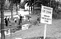
Tannbach in Mödlareuth, 1949

Water barrier in the Tannbach on the former inner-German border in Mödlareuth

Mouth of the Tannbach (opposite) into the Saale (from the right)


Web links
Individual evidence
- ↑ a b Complete table of the Bavarian water directory of the Bavarian State Office for the Environment (XLS, 10.3 MB)
- ↑ Elfriede Ulbricht: The river basin of the Thuringian Saale . 1st edition. Max Niemeyer, Halle (Saale) 1957.