
Mödlareuth
|
Mödlareuth
Töpen municipality
|
||
|---|---|---|
| Coordinates : | 50 ° 25 ' N , 11 ° 53' E | |
| Height : | 543 m above sea level NN | |
| Residents : | 16 | |
| Postal code : | 95183 | |
| Area code : | 09295 | |
Location of Mödlareuth in Bavaria |
||

|
Mödlareuth
City of Gefell
|
||
|---|---|---|
| Coordinates : | 50 ° 25 ' N , 11 ° 53' E | |
| Height : | 543 m above sea level NN | |
| Residents : | 24 | |
| Incorporation : | January 1, 1958 | |
| Incorporated into: | Gebersreuth | |
| Postal code : | 07926 | |
| Area code : | 036649 | |
Location of Mödlareuth in Thuringia |
||

Mödlareuth is a village with 40 inhabitants, which is partly in the Free State of Bavaria ( Hof district with 16 inhabitants) and partly in the Free State of Thuringia ( Saale-Orla district with 24 inhabitants). For 41 years the inner-German border ran right through the village along the Tannbach .
history
Since around the 8th century there has been a thin, predominantly Slavic , but also people from other tribes, settlement in the area around Mödlareuth . In terms of ecclesiastical politics , the dioceses Zeitz (northeast) and Würzburg (southwest) met here after the missionary work by Boniface . However, the diocesan borders were not yet clearly defined. With the relocation of the Zeitz bishopric to Naumburg and the establishment of the Bamberg diocese around 1007 by King Heinrich II , the area became more relevant as a diocese border when the extensive royal parish of Hof , which politically coincided with the realm of Regnitzland, became more and more relevant , developed church life here from 1032.
The existence of Mödlareuth can be traced back to February 19, 1289.
In the 16th century the Tannbach , which flows through Mödlareuth, was established as the border between the Margraviate Bayreuth and the county of Reuss-Schleiz . In 1810 it became the new border between the Kingdom of Bavaria and the Principality of Reuss Younger Line . For centuries, this demarcation had little effect on the population. There was only one school and only one tavern , which were located in the Russian part of Mödlareuth. People went to church in the neighboring Bavarian parish village of Töpen . There was also a joint Mödlareuther male choir.


In 1945 Thuringia, to which the former Principality of Reuss had belonged since 1920, became part of the Soviet zone , while Bavaria became part of the American zone . When the Basic Law for the Federal Republic of Germany and the Constitution of the German Democratic Republic were passed in 1949 , the border between the two German states ran through the town. Traffic between the two parts was now only possible with a pass.
From 1952 the GDR began to provide the inner German border with barriers on one side from the east in order to prevent its citizens from fleeing to the Federal Republic . Mödlareuth was henceforth in the so-called protective strip of the GDR border and until 1989 could not be entered by German citizens at all and by GDR citizens from outside the restricted area only with special permission. From the perspective of the SED regime, “unreliable” residents of areas close to the border were forcibly resettled (so-called “ Action Vermin ”), including some residents of Mödlareuth. The Obere Mühle , located directly on the border, was demolished after its residents had managed to escape to Bavaria, which was just a step away.
In 1952 a full-length board fence was erected on the GDR side, which was replaced in 1958 by a barbed wire fence. In 1966, the GDR border troops built a concrete wall similar to the Berlin Wall , as it was also used in other places directly on the border as a barrier wall and screen. Only in 1973 did a GDR citizen succeed in overcoming the wall at the Untere Mühle (which was then torn down by the GDR border troops) and flee to the Federal Republic. Outside the actual locality of Mödlareuth, the GDR border barriers consisted of a metal mesh fence on which self- firing systems were also installed until 1983 .
During the decades of German division , the GDR part of the village was under the strictest guard day and night, while the Wall developed into a tourist attraction on the West German side. The American soldiers stationed in the region gave the place the nickname Little Berlin ( German: Little Berlin ).
The political turnaround in the GDR and the opening of the inner-German border on November 9, 1989 meant that a border crossing for pedestrians could be opened in Mödlareuth on December 9, 1989, under pressure from Mödlareuth. On June 17, 1990, a section of the Mödlareuther Wall was torn down by an excavator on the initiative of the two "local mayors" Arnold Friedrich and Herbert Hammerschmidt. A section was preserved as a memorial and is now part of the German-German Museum Mödlareuth . The photographer and filmmaker Arndt Schaffner dedicated a large part of his work to documenting the division of Germany using the example of Mödlareuth and is one of the museum's co-initiators.
Mödlareuth today
The Thuringian part of the village of Mödlareuth today belongs to the city of Gefell , the Bavarian part to the municipality of Töpen .
The Mödlareuth open-air museum has been located in Mödlareuth since 1994 with exhibits on the inner-German border. It consists partly of an original piece of the wall, which was preserved as a memorial after reunification , and partly of a reconstructed barrier system, as it was typical for the border of the GDR.

Open-air museum - the low watchtower was at the paper mill in Blankenstein

Former border column (2001)

Original part of the wall
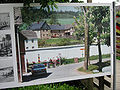
Information board today shows the situation before 1989

Bridge in the center of the village with a water barrier
_IMG_1349.jpg)

_IMG_1357.jpg)


Today you can get from one half of the village to the other unhindered, but some differences have remained. Due to the fact that the place belongs to two federal states, districts and municipalities, there are different place-name signs, postcodes and telephone prefixes, residents dial separately and attend different schools.
With line 710 of the KomBus transport company , Mödlareuth has a connection to the core town of Gefell and from there to the towns of Schleiz , Hirschberg (Saale) , Hof (Saale) , Tanna and Plauen .
Movies
- Sky without Stars, feature film, Germany 1955, directed by Helmut Käutner .
- Stop! Here border - On the trail of the inner-German border Documentary, Germany 2005.
- Andreas Kieling : In the middle of wild Germany (1/5) . Documentary, Germany 2009.
- Tannbach - Schicksal eines Dorfes historical film, Germany / Czech Republic 2014, director: Alexander Dierbach . Three-part ZDF first broadcast on January 4th, 5th and 7th, 2015.
- Tannbach - The Documentation Documentary, Germany 2014. First broadcast on ZDF on January 4, 2015.
- Tannbach II historical film, Germany / Czech Republic 2017, director: Alexander Dierbach. ZDF three-part, first broadcast on January 8, 10 and 11, 2018.
- Ballon (film) feature film, Germany 2018, director: Michael Herbig .
literature
- Jason Johnson: Divided Village: The Cold War in the German Borderlands. New York, Routledge, 2017. ISBN 978-0-415-79377-3 .
- Wolfgang Kahl : First mention of Thuringian cities and villages. A manual . 5th, improved and considerably enlarged edition. Rockstuhl, Bad-Langensalza 2010, ISBN 978-3-86777-202-0 .
- Ludger Stühlmeyer : Curia sonans. The music history of the city of Hof. A study on the culture of Upper Franconia from the foundation of the Bamberg diocese to the present day . Heinrichsverlag, Bamberg 2010, ISBN 978-3-89889-155-4 (also: Münster, Universität, phil. Dissertation, 2010).
Web links
Individual evidence
- ^ Administrative district and ecclesiastical center in the northeast of the Bamberg diocese . In: Ludger Stühlmeyer, Curia sonans . Bamberg 2010, p. 13 f.
- ^ Wolfgang Kahl: First mention of Thuringian towns and villages . 5th, improved and considerably enlarged edition. 2010, p. 183.

Blintendorf | Dobareuth | Frössen | Gebersreuth | Gefell | Göttengrün | Haidefeld | Long green | Mödlareuth (Thuringian part) | Straßenreuth

Fattigsmühle | Hohendorf | Isaar | Royal court | Mödlareuth (Bavarian part) | Moosanger | Obertiefendorf | Pots | Untertiefendorf