Naundorf (Uhlstädt-Kirchhasel)
|
Naundorf
Community Uhlstädt-Kirchhasel
Coordinates: 50 ° 42 ′ 35 ″ N , 11 ° 24 ′ 40 ″ E
|
||
|---|---|---|
| Height : | 217 m | |
| Residents : | 55 (Dec. 31, 2010) | |
| Incorporation : | January 1, 1957 | |
| Incorporated into: | Kolkwitz | |
| Postal code : | 07407 | |
| Area code : | 03672 | |
|
Location of Naundorf in Thuringia |
||
|
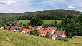
View from the west
|
||
Naundorf is a district of the municipality of Uhlstädt-Kirchhasel in the Saalfeld-Rudolstadt district in Thuringia .
geography
Naundorf is located 210 m above sea level to the right of the Saale on Kreisstraße 121 in the entrance area of the wooded valley into the mountainous region around Mount Kulm near Saalfeld and Rudolstadt. Neighboring places are south of Langenschade , north of Catharinau and north of Kolkwitz . The Schusterstieg from Rudolstadt to Pößneck runs through the town as the shortest connection between the two cities.
history
The hamlet was first mentioned on February 13, 1140. In addition to agriculture, the milling industry once played an important role. The water-powered mills then disappeared through other prime movers. 55 citizens live in the hamlet.
Web links
Individual evidence
- ^ Wolfgang Kahl : First mention of Thuringian towns and villages. A manual. 5th, improved and considerably enlarged edition. Rockstuhl, Bad Langensalza 2010, ISBN 978-3-86777-202-0 , p. 197.
- ↑ Naundorf on the website of the municipality of Uhlstädt-Kirchhasel. Queryed on August 17, 2017


