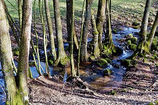
Hellgraben
| Hellgraben | ||
|
The Hellgraben near Steinau |
||
| Data | ||
| Water code | DE : 2478176 | |
| location |
Hessian-Franconian mountainous region
|
|
| River system | Rhine | |
| Drain over | Kinzig → Main → Rhine → North Sea | |
| source | east of Snipes head and south of Steinau -Seidenroth 50 ° 16 '15 " N , 9 ° 27' 45" O |
|
| Source height | approx. 469 m above sea level NHN | |
| muzzle | near Steinau an der Straße in the Kinzig coordinates: 50 ° 18 '42 " N , 9 ° 26' 23" E 50 ° 18 '42 " N , 9 ° 26' 23" E |
|
| Mouth height | approx. 167 m above sea level NHN | |
| Height difference | approx. 302 m | |
| Bottom slope | approx. 55 ‰ | |
| length | approx. 5.5 km | |
| Catchment area | 5.1 km² | |
The Hellgraben is a good five and a half kilometers long left and southern tributary of the Kinzig in the Main-Kinzig district in the Hessian Spessart .
geography
course
The Hellgraben rises at an altitude of about 469 m above sea level. NHN east of the Schnepfenkopf and south of the Steinau district of Seidenroth .
The stream first flows in a northerly direction through mixed forest, then runs north-northwest through fields and meadows and then passes the village of Seidenroth.
It now flows along the western edge of a mixed forest through grassland, crosses under the K 987 and finally flows into the Brothers Grimm town of Steinau an der Straße at an altitude of about 167 m above sea level. NHN from the left into the Kinzig .
Catchment area
The catchment area of the Hellgraben lies in the sandstone Spessart and is drained to the North Sea via the Kinzig, Main and Rhine rivers.
It borders
- in the northeast to that of the Sennelsbach , a tributary of the Kinzig
- in the southeast to that of the Rohrbach , which drains into the Main via the Jossa , the Sinn and the Franconian Saale
- in the south to that of the Jossa tributary Distelbach
- in the southwest to that of the Kinzig tributary Klingbach
- and in the west to that of the Auerbach , also a tributary of the Kinzig.
The highest point is the 490 m high Schnepfenkopf in the southwest of the catchment area.
The southern and western areas of the catchment area are mostly forested, otherwise grassland and arable land alternate.
