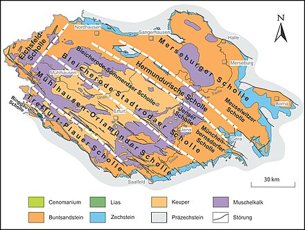
Treffurt – Plauer Scholle
The Treffurt – Plauer Scholle is the southwestern of the four Hercynian clods located predominantly in Thuringia , ie from northwest to southeast running main clods in the area of the Thuringian Basin and its edge plates .
description
The plaice runs through various strata of the red sandstone and the shell limestone from the southern edge of the Leinegraben along the Werra valley and its right edge heights ( Lower Werraland with Höheberg ; Gobert , Wanfrieder Werrahöhen ) from Witzenhausen ( Werra-Meißner district , Hesse ) via Treffurt to Hörschel ; It also runs through the west Thuringian mountain and hill country north of Eisenach, which is rich in keuper, and its marginal heights of shell limestone ( Hörselberge ) and red sandstone ( Waltershäuser Vorberge near Waltershausen ) to the muschelkalk plateau of the Ohrdrufer Platte east of Ohrdrufs together with Reinsbergen and in the northeastern sandstone of the Paulinzella foothills of the Paulinz sandstone Ilmenaus finally to the edge of the Thuringian Slate Mountains near Königsee .
Limitations
To the northeast, the Treffurt – Plauer Scholle is bounded by the Eichenberg – Gotha – Saalfelder fault zone , beyond which the Mühlhausen – Orlamünder Scholle of the southwest Thuringian Basin connects; to the southeast it borders in the outer northwest on the East Hessian red sandstone clod of the East Hessian mountainous region with the Fulda-Werra mountainous region , in the northeast on the Ringgau clod of the Ringgau and in the middle and south-east of the southwest flank directly on the Thuringian Forest ( Thuringian Forest Northeast Rim Fault ) or to the Thuringian Slate Mountains .
Individual evidence
- ^ D. Franke: Regionalgeologie Ost - Geological online lexicon for East Germany
