Querfurter plate and Untere Unstrut plates
| Querfurter plate and Untere Unstrut plates | |||
|---|---|---|---|
| surface | 446 km² | ||
| Systematics according to | Handbook of the natural spatial structure of Germany | ||
| Greater region 1st order | Low mountain range threshold | ||
| Main unit group | 47/48 → Thuringian Basin (with edge plates) |
||
| Natural space |
489 → Querfurter plate and lower Unstrut plates |
||
| Geographical location | |||
| Coordinates | 51 ° 19 '21.4 " N , 11 ° 38' 18.2" E | ||
|
|||
| circle | Saalekreis , Mansfeld-Südharz district , Burgenlandkreis | ||
| state | Saxony-Anhalt | ||
| Country | Germany | ||
The Querfurter Platte and Untere Unstrutplatten are a plate landscape along the Untere Unstrut and the Middle Saale and up to the southeastern edge of the Harz in southwestern Saxony-Anhalt in the border area to Thuringia ( Germany ). As part of the north-east framing of the Thuringian Basin, it represents a main unit of the main unit group Thuringian Basin (with edge plates) according to the manual of the natural spatial structure of Germany .
The landscape stands out from most of the neighboring landscapes through the presence of shell limestone . The best-known region is the wine - growing landscape at the confluence of the Ilm , Saale and Unstrut rivers.
Geographical location
They extend over the districts of Saalekreis , Mansfeld-Südharz , Burgenland in Saxony-Anhalt and to a minimal extent in Weimarer Land in Thuringia. The landscapes lie between Mülocken and Schraplau in the east, Weißenfels in the southeast, Naumburg in the south, Bad Sulza in the extreme southwest and Nebra and Laucha on the Unstrut in the mid-west. A northern branch extends into the Harz region near Blankenheim, southeast of Eisleben . The largest city within the natural area is Querfurt in the northern part.
Natural classification
The landscape, which has a total area of approx. 489 km², represents the main unit 489 within the natural spatial main unit group Thuringian Basin (with edge plates) .
Adjacent natural spaces and landscapes are:
- the southeastern edge of the Harz in the north
- the eastern Harz foreland in the northeast
- the Halle - Leipzig lowland bay in the east
- the Altenburg-Zeitzer loess area in the southeast
- the Ilm-Saale-Platte in the south
- the Thuringian Basin in the southwest
- the red sandstone landscapes of Finne and Ziegelrodaer Forst in the west
The Federal Agency for Nature Conservation (BfN) has created a slightly different structure and division according to the landscape profiles:
- 48900 Querfurter Platte and Untere Unstrutplatten with a total area of 807 km² also includes parts of the eastern Harz foreland and the Halle-Leipzig lowland bay
- 50,000 Eastern Harz foreland for a small proportion in the far north
- 50202 Lower Unstruttal for the breakthrough valley between Laucha and Naumburg
Partial landscapes
The natural area consists of different sub-landscapes:
- The Untere Unstrut plates on both sides of the Untere Unstrut reach in the south near Naumburg just over the right bank of the Saale and near Bad Sulza on both sides of the Ilm in Thuringia. The southwestern part between Eckartsberga and Bad Sulza is to be regarded as the southern branch of the Finns .
- The Querfurter Platte in the middle part with its flat wavy character.
- A northern branch with parts of the Hornburger saddle in the extreme north.
Geology and nature

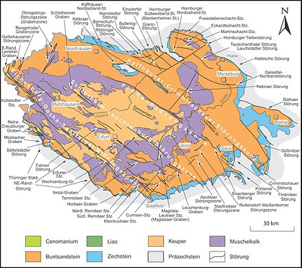
The main type of rock is shell limestone. To the west at the transition to the red sandstone of the Untere Unstrut mountain and hill country and to the Thuringian Basin, the plate ends in part with a steep step. To the east it flattens out more and more and merges into the Halle-Leipzig lowland bay without a sharp border. A layer of loess increases from west to east and is already several meters thick there. At Freyburg there is a prehistoric valley of the Urilm, where there are mighty gravel beds from the Thuringian Forest . The Finn Fault separates the Unstrut Plate from the Thuringian Basin and the Ilm-Saale Plate.
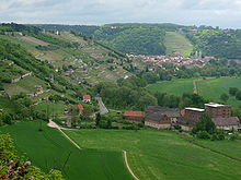
Large parts of the landscape are used for agriculture because of the good soil, only the steeper slopes, especially along the Unstrut, Ilm, Saale and their small tributaries are forested. The narrow and steep breakthrough valleys with their protected climate are the northernmost wine-growing area ( Saale-Unstrut region ) in Germany.
The southern part of the natural area belongs to the Saale-Unstrut-Triasland nature park .
mountains
The height of the mountains and elevations decreases from southwest to northeast:
- Schloßberg (299.6 m), immediately south of Eckartsberga (part of the Finn Fault )
- nameless mountain (294.1 m), west of Bischofrode (Hornburger Sattel)
- Hühnerberg (285.7 m), south of Burkersroda
- nameless mountain (269.6 m), west of Bad Kösen
- Langer Berg (261.8 m), west of Roßbach
- Barnstädter Huthügel (244.5 m), south of Barnstädt (Querfurter Platte)
- nameless mountain (232.2 m), west of Freyburg (with Neuenburg Castle )
- Gleinaer Berge (231.9 m), west of Gleina
Individual evidence
- ↑ a b E. Meynen and J. Schmithüsen : Handbook of the natural spatial structure of Germany - Federal Institute for Regional Studies, Remagen / Bad Godesberg 1953-1962 (9 deliveries in 8 books, updated map 1: 1,000,000 with main units 1960)
- ↑ Handbook of the natural spatial structure of Germany, page 756


