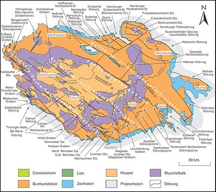
Schlotheim – Leuchtenburg fault zone
The Schlotheim-Leuchtenburg Fault Zone is a hercynisch , ie from northwest to southeast, through the Thuringian basin and its southeastern edge plates extending geological fault zone . It stretches from the northwest of Schlotheim in the Unstrut-Hainich district to the southeast of the Leuchtenburg in the Saale-Holzland district in Seitenroda , but is interrupted for a distance of around 35 kilometers in Keuperbecken, central Thuringia . Further Hercynian fault lines occur south-east of the Leuchtenburg. T. move to the Thuringian Slate Mountains .
The fault zone separates the two main clods of the Thuringian Basin, the Bleicherode – Stadtrodaer plaice in the northeast and the Mühlhausen – Orlamünder plaice in the southwest.
structure
The Schlotheim-Leuchtenburg fault zone is mainly divided into three partial fault zones that are spatially separated from one another.
Northwest
The north-west of the fault zone is occupied by the Schlotheimer Graben , which runs along the Notter from Obermehler to Schlotheim , from there upstream along the Marolteroder Bach and further downstream along the Schambach- Oberlauf Fernebach to Bruchstedt . The actual ditch is flanked in the northwest by the Volkenroder forest , and later by the Heilinger heights . These hills of the Upper Muschelkalks slope down towards the actual ditch in a steep step .
Core zone
Only 35 km southeast of the southeast end of the Schlotheimer Graben does the core area of the Schlotheim-Leuchtenburg fault zone begin with the Ilmtal-Graben , the northwest of which begins at the foot of the Ettersberg . Contrary to its name, it does not run along the Ilm , but extends its valley near Weimar to the northwest. The filling of the trench consists of keuper , which is flanked by Upper Muschelkalk . The northeast flank coincides with the steep southwest flank of the Ettersberg.
In the middle of the urban area of Weimar , the Ilmtal-Graben merges into the Magdalaer Graben , which follows the course of the Ilm from Weimar upstream to above Mellingen and then upstream of the Magdel via Magdala to the district of Göttern , where the ditch to the south-east roughly on the district boundary of the Weimar-Land district expires to form the Saale-Holzland district .
The structure of the Magdaler Graben is quite similar to the Ilmtal Graben.
To the northwest of Magdala, the Magdaler Graben is crossed at an obtuse angle by the Apolda fault zone coming upstream of the Herressener Bach from Apolda in the north-northeast . This follows south of Göttern the upper reaches of the Magdel to the south-south-west to about Loßnitz in the far east of Blankenhain .
The Leutra fault zone , which connects to the west of the Saale-Holzland district and to the southwest of the city of Jena (district of Leutra ), differs significantly in its structure from the two trenches. It does not flank the course of the Leutra stream flowing east of the Saale , but crosses it in various, Hercynian parallel fault lines. Southeastern extensions of the fault can also be found, some distance away, to the right of the Saale. The partial defects hardly appear as a surface shape.
The core zone of the Schlotheim – Leuchtenburg fault zone divides the Ilm-Saale-Platte in particular into the actual Ilm-Saale-Platte in the southwest and the Jenaer Scholle in the northeast. The latter also occurs to the east in prominent ridges such as the Wöllmisse and the horseshoe over the Saale; it is bounded to the west by the Apolda fault zone.
Orographic boundary between the two partial plates are about the Ilm, the Magdel stream upwards to the gods and A 4 , which follows the Saale towards the Leutra.
southeast
The Leuchtenburg ditch , named after the Leuchtenburg, runs on both sides of the Saale near Kahla , south parallel to the Leutra fault zone and its southeastern foothills. In contrast to this, however, it represents a largely coherent unit.
The trench filling consists mainly of shell limestone , its flanking of red sandstone .
After some interruption, the fault line of the Leuchtenburg trench experiences some continuations to the southeast, which extend into the East Thuringian slate mountains . For the most part, these are only developed as weaker flexures (see map above - in the "stricter" hydrogeological maps from TLUG Jena, only stronger faults are shown within these continuations ).
Individual evidence
- ↑ Hydrogeological map of Thuringia from the Thuringian State Institute for Environment and Geology (PDF; 4.37 MB) ( Even finer maps are available for each district .)
Web links
- D. Franke: Regionalgeologie Ost - Geological online lexicon for East Germany
