
Weimarer Land district
| coat of arms | Germany map |
|---|---|

|

Coordinates: 51 ° 0 ' N , 11 ° 25' E |
| Basic data | |
| State : | Thuringia |
| Administrative headquarters : | Apolda |
| Area : | 804.48 km 2 |
| Residents: | 82,156 (Dec. 31, 2019) |
| Population density : | 102 inhabitants per km 2 |
| License plate : | AP, APD |
| Circle key : | 16 0 71 |
| NUTS : | DEG0G |
| Circle structure: | 39 municipalities |
| Address of the district administration: |
Bahnhofstrasse 28 99510 Apolda |
| Website : | |
| District Administrator : | Christiane Schmidt-Rose ( CDU ) |
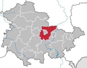
| Location of the Weimarer Land district in Thuringia | |
  |
|
The district of Weimarer Land (according to the statutes Kreis Weimarer Land ) is a district in Thuringia , which extends from the state capital Erfurt east to the state border with Saxony-Anhalt . The county seat is Apolda .
geography
Location in Thuringia
The district of Weimarer Land is located in the eastern center of Thuringia and is part of the Central Thuringia planning region . Neighboring districts in the north are the district of Sömmerda and the Saxony-Anhalt Burgenland district , in the east the Saale-Holzland district and the independent city of Jena , in the south the district of Saalfeld-Rudolstadt , in the southwest the Ilm district and in the west the independent city of Erfurt . The independent city of Weimar is completely surrounded by the Weimarer Land district.
Landscape, natural spaces and mountains
The Weimarer Land district can be divided into two natural areas , both of which are heavily used by agriculture.
Its southern part consists mainly of the Ilm-Saale-Platte , which shows a frequent change in soil and area use and represents a shell limestone mountainous region and the beech is the most common tree on sand-lime stone, while in the Tannroda, Blankenhain, Bad Berka area on red sandstone spruce and pine can be found almost exclusively.
The northern area is mainly part of the Thuringian Basin or the Central Thuringian Ackerhügelland. Like the southern part, it is heavily influenced by agriculture, which results mainly from the widespread loess soil, and has only slight differences in altitude of up to 100 meters at an altitude of 200 to 300 m above sea level. NN on. In geological terms, the northern part belongs to the Thuringian Keuperbecken. It has almost no forest areas. The largest north-south expansion of the district is approx. 33 km, the largest east-west expansion approx. 36 km.
The highest elevation in the district is at 513 m above sea level. NN the Riechheimer Berg in the municipality of Hohenfelden. Its deepest point is at the confluence of the Ilm and Saale rivers near Großheringen at 118 m above sea level. NN . In the north of the district are the ridges of the Finns and in the south the Tannrodaer Waldland and foothills of the Thuringian Forest .
Mountains in the Weimarer Land district:
→ see also paragraph Ilm-Saale-Platte of the article List of Mountains in Thuringia
| Surname | Height (m above sea level ) |
local community |
|---|---|---|
| Riechheimer Berg | 513 | Hohenfelden |
| Kaitsch ( Kötsch ) | 497 | Kiliansroda |
| Windberg | 484 | Crane field |
| Kesselberg | 463 | Keßlar |
Land use

The use of the district area differs in numerous municipalities. In the northern district almost always over 80 percent of the community area is used for agriculture, which is also the case in some southern communities, such as Lehnstedt, Kleinschwabhausen and Magdala. The largest proportion of forest area is often found in the south, at over 25 percent. In the rest of the district, this value is usually 2 to 10 percent. The proportion of settlement and traffic area depends on the size of the municipality and is therefore highest in Apolda with 20.9 percent and lowest in Buchfart, Döbritschen, Gebstedt, Hammerstedt and Rittersdorf with less than 5 percent. Since there are no large, natural bodies of water, the water area is concentrated on the Hohenfelden reservoir , the Großbrembach dam and the agricultural water reservoirs at Vippachedelhausen and Schwerstedt. The remaining area is mostly used for mining.
| Type of use | Weimar Country | Thuringia |
|---|---|---|
| Settlement and traffic areas | 72.21 km² 9.0% |
1,477.91 km² 9.14% |
| Forest | 129.29 km² 16.1% |
5,156.75 km² 31.9% |
| Farmland | 582.20 km² 72.5% |
8,736.29 km² 54.02% |
| Bodies of water | 8.03 km² 1.0% |
193.97 km² 1.20% |
| total | 803.03 km² | 16,171.96 km² |
Landscape and nature reserves

There are three protected landscape areas in Weimarer Land . The largest is the "Ilm Valley" with an area of approximately 19,850 hectares. It stretches from Oettern to Kranichfeld and partly extends into the Ilm district, the city of Weimar and the city of Erfurt . The " Middle Saale Valley " is almost 19,150 hectares in size and only touches the district on the northern and eastern border with the Saale-Holzland district . The smallest landscape protection area is the "Schötener Grund". It stretches from the center of Apolda to the village of Schöten and is about 50 hectares in size.
In addition to the three landscape protection areas, the district also has a share in eight nature protection areas , four of which belong exclusively to the Weimarer Land. The area "Seeteich Blankenhain" has a size of 15.4 hectares and is located in the Tannrodaer Waldland . It is a wetland with a pond, reed beds, a stream with accompanying trees, smaller wet meadows and other biotopes. The " Lohholz " area lies between the communities of Eckolstädt in the Weimarer Land and Hirschroda in the Saale-Holzland district and is 30.4 hectares in size. It consists largely of a forest area as well as a meadow orchard in the north and an oat and wet meadow in the east. The "Großschwabhäuser Grove", almost 54 hectares in size, is also a forest area, which is mainly characterized by mixed deciduous forests and is of regional importance as a habitat for rare, endangered and endangered species. Other landscape protection areas in the Weimarer Land are the "Prinzenschneise" (101 hectares) and the "Südhang Ettersberg" (408.3 hectares), some of which are in Weimar, as well as the "Diebskammer" (73 hectares), the "Maientännig" (80.5 hectares) Hectares) and the "Weißenberg" (34.8 hectares), which are only in the area of the Weimarer Land.
history
History of the administrative unit
The district of Weimarer Land was created in 1994 as part of the district and community reform of Thuringia by amalgamating the old districts of Apolda and Weimar-Land , whereby communities of the old district of Erfurt-Land and the municipality of Drößnitz of the district of Jena-Land were incorporated at the same time . The administrative seat is the city of Apolda. The Apolda district office has a branch in Weimar.
In 1994 the municipalities of Gaberndorf, Gelmeroda, Legefeld, Niedergrunstedt, Possendorf, Süßenborn, Taubach and Tröbsdorf were joined to the independent city of Weimar from the former Weimar district. On January 1, 1997, the Neckeroda community moved from the Saalfeld-Rudolstadt district to the Weimarer Land district.
Population development
Development of the population:
|
|
|
|
|
- Data source: from 1994 Thuringian State Office for Statistics - values from December 31st
politics
District council
The local elections on May 26, 2019 in the Weimarer Land district led to the result shown in the diagram opposite. This resulted in the following distribution of seats in the district council:

The local elections from 1990 to 2019 had the following results (the results of the 2019 election are shown in bold):
| Parties and constituencies | % 1994 |
Seats 1994 |
% 1999 |
Seats 1999 |
% 2004 |
Seats 2004 |
% 2009 |
Seats 2009 |
% 2014 |
Seats 2014 |
% 2019 |
Seats 2019 |
|
|---|---|---|---|---|---|---|---|---|---|---|---|---|---|
| CDU | Christian Democratic Union of Germany | 35.4 | 19th | 38.6 | 21st | 41.8 | 20th | 34.2 | 16 | 35.8 | 17th | 33.5 | 15th |
| AfD | Alternative for Germany | - | - | - | - | - | - | - | - | 4.6 | 2 | 17.6 | 8th |
| FWW 1 | Free voters Weimarer Land | 3.4 | - | 4.1 | - | 11.1 | 5 | 18.2 | 8th | 14.7 | 7th | 12.6 | 6th |
| LEFT 2 | THE LEFT | 13.0 | 7th | 13.2 | 7th | 19.7 | 9 | 16.4 | 8th | 16.0 | 7th | 10.7 | 5 |
| KVBIWL 3 | District Association of Citizens' Initiatives Weimarer Land | - | - | - | - | - | - | - | - | 2.6 | 1 | 7.1 | 3 |
| GREEN | Alliance 90 / The Greens | 5.4 | 3 | 2.0 | - | 3.1 | - | 4.7 | 2 | 4.5 | 2 | 6.7 | 3 |
| SPD | Social Democratic Party of Germany | 21.8 | 12 | 26.9 | 15th | 13.1 | 6th | 18.1 | 8th | 13.9 | 6th | 6.6 | 3 |
| FDP 4 | Free Democratic Party | 9.4 | 5 | 5.0 | - | 5.9 | 3 | 8.4 | 4th | 3.5 | 2 | 4.1 | 2 |
| NPD | National Democratic Party of Germany | - | - | - | - | - | - | - | - | 3.0 | 1 | 1.2 | 1 |
| PIRATES | Pirate Party Germany | - | - | - | - | - | - | - | - | 1.3 | 1 | - | - |
| CitizenA 5 | Citizens' Alliance of Thuringia | - | - | 5.5 | 3 | 5.2 | 3 | - | - | - | - | - | - |
| total | 100 | 46 | 100 | 46 | 100 | 46 | 100 | 46 | 100 | 46 | 100 | 46 | |
| Voter turnout in% | 74.1% | 62.8% | 56.2% | 56.4% | 56.2% | 64.7% | |||||||
District Administrator
Christiane Schmidt-Rose (CDU) has been the district administrator of the Weimarer Land district since 2018 . It replaced the non-party Hans-Helmut Münchberg , who had been in office since the district was founded in 1994 and had previously been district administrator of the previous district of Apolda from 1990 to 1994.
badges and flags

The coat of arms was approved on November 24, 1994 by the Thuringian State Administration Office. In the coat of arms of the district, the coats of arms of different rulers are brought together, which were of importance in the area of the district.
Blazon : “Half-divided and split; above in front a silver six-spoke wheel in red, below in front in silver three red apples (2: 1) and behind in gold a black lion with a red tongue and armor. "
The six-spoke silver wheel on the red background stands for the Mainz wheel from the Erfurt city arms. The communities of Kapellendorf, Tonndorf and Blankenhain were owned by Erfurt for a long time. The three red apples on a silver background refer to the Lords of Apolda . The black lion with a red tongue on a golden background stands for the Meissen lion and symbolizes the areas of the Grand Duchy of Saxony-Weimar-Eisenach .
The flag of the district, approved on November 24, 1994, has white and red stripes lengthways and bears the district's coat of arms.
District partnerships
The Weimarer Land district maintains a partnership with the following districts:
- Groß-Gerau district in Hesse
- District of Freising in Bavaria
- Waldeck-Frankenberg district in Hesse
economy
In the 2016 Future Atlas, the Weimarer Land district was ranked 303 out of 402 districts and urban districts in Germany, making it one of the districts with “future risks”.
Medium-sized companies and tradespeople form the focus of the economy in this district. Another not inconsiderable source of income is the “culture and tourism industry”.
Health economy

The Robert Koch Hospital Apolda is a hospital with the district as sponsor, the Central Clinic Bad Berka belongs to the Rhön Clinic AG , while the Blankenhainer Clinic has been part of the Helios Clinics since 1997 .
There are three rehabilitation clinics in Bad Berka, all of which belong to the median group . Bad Sulza has two rehabilitation clinics, the Sophienklinik with a wide range of indications is a subsidiary of the Sophien- und Hufeland-Klinikum Weimar . There is also the Bad Sulza Clinic Center as a rehabilitation clinic for dermatology, pneumology and orthopedics with psychological service.
traffic
Road traffic
The district is crossed by a motorway and three federal highways . The federal highway 4 runs through the district from Magdala in the east to Klettbach in the west and has the junctions Magdala, Apolda, Nohra and Erfurt-Ost in the district area, the latter being on the border with Erfurt. The motorway is four lanes up to Magdala and six lanes between Apolda and Erfurt-Ost.
The most important federal road is the B 87 from Ilmenau to Frankfurt (Oder) , which runs through the district of Rannstedt in the northeast to Kranichfeld in the southwest and on which the cities of Apolda and Bad Berka are located. Between the AS Apolda in Mellingen and Bad Berka , it was downgraded to the K511 district road. The B 87 is crossed by the B 7 in Umpferstedt , which runs almost parallel to the A 4. It connects the cities of Erfurt and Jena and thus the western and eastern southern parts of the Weimar region. The B 85 , like the B 87, runs from north to south and connects the towns of Buttelstedt, Bad Berka and Blankenhain in the district. It crosses the B 87 in the city center of Bad Berka. The B 7 and B 85 also run through the urban area of Weimar.
This road network is complemented by the state road 1053 from the AS Nohra to Bad Berka, the L 1057 from Buttstädt to Apolda, the L 1052 from the AS Erfurt-Ost via Klettbach to Kranichfeld, the L 1054 from Weimar via Berlstedt to the AS Sömmerda-Süd the A 71 , the L 1055 from Berlstedt to Erfurt-Kerspleben, the L 1059 from Apolda to Camburg, the L 1060 from Großheringen via Bad Sulza, Apolda, Jena-Isserstedt, Magdala to Blankenhain, the L 1061 from Großheringen to Camburg and the L 2158 from Reisdorf to Bad Sulza.
The regular bus service, which serves every place in the district, forms the main carrier of local public transport in Weimarer Land alongside rail traffic. Based on the historical district boundaries, this is carried out by two companies, the Apolda mbH and Stadtwirtschaft Weimar .
Rail transport
The new Erfurt – Leipzig / Halle line , which was completed in 2015 and touches the north-western part of the district, runs in the district. Two other main routes are the Thuringian Railway , which runs from Halle (Saale) via Erfurt to Eisenach and has six stations in the district with the stations Großheringen , Bad Sulza , Niedertrebra , Apolda , Oßmannstedt and Hopfgarten , as well as the " Central Germany Connection " from Aachen via Cologne, Kassel and Erfurt to Chemnitz, which has two stops in the district with the train stations Mellingen and Großschwabhausen . The Weimar – Jena section located within the district has two tracks, but has not yet been electrified.

There are also two branch lines that are of regional importance. The “ Ilm Valley Railway ” runs from Weimar via Bad Berka to Kranichfeld and is around 25 kilometers long. Trains run on it every hour, which considerably improves the development of the southern district. The " Pfefferminzbahn " is only used for freight traffic between Eckartsberga and Großheringen . Großheringen train station also has a connection to the “ Saalbahn ” in the direction of Jena and Saalfeld / Saale .
Air traffic
The district does not have its own international airport . The next airport of this type is in Erfurt. The municipalities of Bad Berka and Umpferstedt each have a special landing site . Near the county border also contains the airfields Jena Schöngleina in Saale-Holzland-Kreis, Rudolstadt-Groschwitz in Saalfeld-Rudolstadt and Alkersleben in Ilm-Kreis.
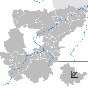
Communities
Apolda is designated as a middle center according to the regional plan.
The basic centers are Bad Berka , Bad Sulza and Blankenhain .
(Residents on December 31, 2019)
|
community-free municipalities
|
|
  |
Administrative communities
* Administrative headquarters
|
|
For the terms "administrative community" and "fulfilling community" see administrative community and fulfilling community (Thuringia) .
Territorial changes
Communities
- Dissolution of the Drößnitz community - incorporation into Blankenhain (September 2, 1995)
- Dissolution of the municipalities of Eckolstädt , Großromstedt , Hermstedt , Kleinromstedt , Kösnitz , Münchengosserstädt , Pfuhlsborn , Stobra and Wormstedt - merger to form the municipality of Saaleplatte (March 15, 1996)
- Dissolution of the Neckeroda community from the Saalfeld-Rudolstadt district - incorporation into Blankenhain (January 1, 1997)
- Dissolution of the community of Hohlstedt - incorporation into Großschwabhausen (December 1, 2007)
- Dissolution of the municipality of Hottelstedt - incorporation into Berlstedt (December 1, 2007)
- Dissolution of the Utzberg community - incorporation into Nohra (December 1, 2007)
- Dissolution of the Gutendorf community - incorporation into Bad Berka (December 1, 2008)
- Dissolution of the communities Auerstedt , Flurstedt , Gebstedt , Reisdorf and Wickerstedt - incorporation into Bad Sulza , which is raised to a rural community (December 31, 2012)
- Dissolution of the municipalities of Liebstedt , Mattstedt , Niederreißen , Niederroßla , Nirmsdorf , Oberreißen , Oßmannstedt , Pfiffelbach and Willerstedt - merger to form the rural municipality of Ilmtal-Weinstrasse (December 31, 2013)
- Dissolution of the municipality of Ködderitzsch - incorporation into Bad Sulza (January 1, 2019)
- Dissolution of the municipalities of Berlstedt , Buttelstedt (city), Großobringen , Heichelheim , Kleinobringen , Krautheim , Ramsla , Sachsenhausen , Schwerstedt , Vippachedelhausen and Wohlsborn - merger to form the city and rural municipality of Am Ettersberg (January 1, 2019)
- Dissolution of the municipalities of Kromsdorf , Rohrbach and Leutenthal - incorporation into the Ilmtal-Weinstrasse (January 1, 2019)
- Am Ettersberg is no longer a city (August 1, 2019)
- Dissolution of the municipalities Bechstedtstrasse , Daasdorf a. Berge , Hopfgarten , Isseroda , Mönchenholzhausen , Niederzimmer , Nohra , Ottstedt a. Berge and Troistedt - merger to form the city and rural community of Grammetal (December 31, 2019)
- Dissolution of the municipality of Saaleplatte - incorporation into Bad Sulza (December 31, 2019)
Administrative communities and fulfilling communities
- Dissolution of the administrative communities Kleinromstedt and Wormstedt - merger to form the administrative community Ilm-Saale-Platte (October 11, 1994)
- Dissolution of the administrative communities Isseroda and Tröbsdorf - merger to form the administrative community Grammetal (November 3, 1994)
- The city of Blankenhain becomes a fulfilling municipality for the city of Magdala (January 1, 1996)
- Dissolution of the Bad Sulza administrative community - the city of Bad Sulza becomes a fulfilling municipality for all member municipalities (February 15, 1996)
- Dissolution of the administrative community Ilm-Saale-Platte - formation of the municipality of Saaleplatte (March 15, 1996)
- The city of Blankenhain is no longer a fulfilling municipality for the city of Magdala - expansion of the administrative community Mellingen to include the city of Magdala (January 1, 2002)
- Leaving the community Good village from the Grammetal (30 November 2008)
- The city of Bad Sulza is no longer a fulfilling municipality for the municipalities of Auerstedt , Flurstedt , Gebstedt , Reisdorf and Wickerstedt (December 31, 2012)
- The city of Bad Sulza becomes a fulfilling municipality for the municipality of Saaleplatte (December 31, 2013)
- Dissolution of the administrative community Ilmtal-Weinstrasse - conversion into the rural community Ilmtal-Weinstrasse with the exception of the community Kromsdorf ; Ilmtal-Weinstrasse becomes the fulfilling municipality (December 31, 2013)
- Dissolution of the Berlstedt and Buttelstedt administrative communities - merger to form the Nordkreis Weimar administrative community (December 31, 2013)
- The city of Bad Sulza is no longer fulfilling municipality for the municipality of Ködderitzsch (January 1, 2019)
- Dissolution of the administrative community north of Weimar - conversion into the city and rural community Am Ettersberg with the exception of the communities Ballstedt , Ettersburg , Neumark (city), Leutenthal and Rohrbach ; Am Ettersberg becomes the fulfilling municipality for Ballstedt, Ettersburg and Neumark; Incorporation of Leutenthal and Rohrbach into the rural community of Ilmtal-Weinstrasse (January 1, 2019)
- Dissolution of the administrative community Grammetal - conversion into the rural community Grammetal (December 31, 2019)
- The city of Bad Sulza is no longer a fulfilling municipality for the municipality of Saaleplatte (December 31, 2019)
License Plate
On July 1, 1994, the district was assigned the vehicle distinguishing sign APD (Apolda). This was replaced on February 1, 1995 by the new distinctive sign AP .
Until about the year 2000, vehicles from the sub-circles were given special identification numbers:
| area | Letters | numbers |
|---|---|---|
| Part circle Apolda | A to N | 1 to 999 |
| AA to NZ | 1 to 99 | |
| Weimar district | P to Z | 1 to 999 |
| PA to ZZ | 1 to 99 |
The abbreviation APD has been available again since November 24, 2012 .
Attractions
The Weimarer Land is characterized by its natural beauty ("Tuscany of the East").
Particularly noteworthy are:
- the Kunsthaus Apolda
- the spa town of Bad Berka
- the spa town of Bad Sulza with the Toskana Therme
- the upper castle Kranichfeld
- the Hohenfelden open-air museum
- the moated castle Kapellendorf
- the Wielandgut Oßmannstedt
- the Kromsdorf Castle
- the order commandery Liebstedt
- the Auerstedt manor
- the Thuringian Dumpling Museum Heichelheim
- an extensive network of (bike) hiking trails: "Klassikerstraße", "Goethe-Wanderweg", "Feininger-Wanderweg", "Napoleon-Wanderweg", "Ilmradwanderweg", "Porzellanstraße", "Bier-" and "Burgenstraße", " Thuringia Trail "
See also
- List of churches in the Weimarer Land district
- List of organs in the district of Weimarer Land and in the city of Weimar
- List of bells in the Weimarer Land district and in Weimar
Web links
- Official website of the Weimarer Land district
- Thuringian State Institute for Environment and Geology
- Area information (Kreisblatt) from the Thuringian State Office for Statistics
literature
- Karl Moszner, Eberhard Neumeyer, Alexandra Gentsch: The district of Weimar 1990-1994. A look back. Publisher: Landrat des Landkreis Weimar, 54 pages, size 22 cm × 21 cm, Hahndruck, Kranichfeld 1994, without ISBN
Individual evidence
- ↑ a b Population of the communities from the Thuringian State Office for Statistics ( help on this ).
- ↑ § 1 Name and Seat . In: Main statutes of the Weimarer Land district . As of February 19, 2015, accessed on September 15, 2016 (PDF; 48 kB): "The district bears the name 'Weimarer Land'."
- ↑ Nature reserves in the Weimarer Land district. Thuringian State Institute for Environment and Geology (TLUG), 2011, accessed on April 13, 2011 .
- ↑ District election in Weimarer Land 2019 In: wahlen.thueringen.de .
- ↑ Erfurt-Weimar-Jena - The ImPuls Region (pdf), on impulsregion.de
- ↑ Zukunftsatlas 2016. Archived from the original ; accessed on March 23, 2018 .
- ^ Regional plan Central Thuringia of April 12, 2011 , accessed on October 16, 2016
Cities : Eisenach | Erfurt | Gera | Jena | Suhl | Weimar
Districts : Altenburger Land | Eichsfeld | Gotha | Greiz | Hildburghausen | Ilm district | Kyffhäuserkreis | Nordhausen | Saale-Holzland district | Saale-Orla district | Saalfeld-Rudolstadt | Schmalkalden-Meiningen | Sömmerda | Sonneberg | Unstrut-Hainich Circle | Wartburg district | Weimar Country