
Hottelstedt
|
Hottelstedt
Rural community Am Ettersberg
Coordinates: 51 ° 2 ′ 14 " N , 11 ° 13 ′ 43" E
|
||
|---|---|---|
| Height : | 320 m above sea level NN | |
| Area : | 5.55 km² | |
| Residents : | 212 (December 31, 2006) | |
| Population density : | 38 inhabitants / km² | |
| Incorporation : | December 1, 2007 | |
| Incorporated into: | Berlstedt | |
| Postal code : | 99439 | |
| Area code : | 036452 | |
Location of Hottelstedt in Thuringia |
||
 Village church
|
||

Hottelstedt is a district of the rural community Am Ettersberg in the north of the Weimarer Land district . Hottelstedt has about 200 inhabitants.
location
Hottelstedt is located on the northwestern slope of the Ettersberg and on the southern edge of the Thuringian basin . The district road 512 connects the district with traffic. The forest of the Ettersberg and green erosion channels loosen up the arable area somewhat.
history
Hottelstedt was first mentioned in 1322 as Hottenstede. The mention in a property register of the Reichsabtei Fulda, which dates before 900, as an Otenstat is uncertain. Presumably the place is Ottstedt a. Mountains meant. In 1487, Hottelstedt was sold to the von Wirchshausen family. January 16, 1194 is given in the literature.
The main livelihood of the place was agriculture. Also Waidanbau was operated, then in 1542 two Waidgärten be detected. The operation of a community restaurant with its own brewery and two windmills from the 19th century at the latest are documented.
Since 1578 there was a school in the village that employed only one teacher until 1945. Today the children visit the school center in Berlstedt. The parish of the village was first mentioned in 1328.
During the National Socialist era, the Buchenwald concentration camp was built on the western slope of the Ettersberg on Hottelstedter Flur . The site of the concentration camp was incorporated into Weimar in 1938.
On December 1, 2007, Hottelstedt was incorporated into Berlstedt, which became part of the newly founded rural community Am Ettersberg on January 1, 2019.
Attractions
The following buildings in the village are on the list of monuments of the Weimarer Land district:
- Church with churchyard : The late Gothic church with its almost square west tower dates from the 16th century. A predella from the first altar is still present from the initial configuration . The current altar, however, dates from the 18th century. The church has a three-part bell. A bell from this was created in 1695 by the Erfurt bell founder Hans Christoph Geyer .
- Rectory, in the village 16
- Death march memorial from 1984 on Buchenwaldstrasse / Kleiner Anger to commemorate the death march of prisoners from Buchenwald concentration camp who were driven through the town in April 1945

Memorial at the eastern exit of the village for Combat Unit 9 of the 6th Panzer Division of the 3rd US Army , which found and liberated the Buchenwald concentration camp on April 11, 1945
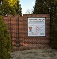
Death March Memorial


Individual evidence
- ^ Wolfgang Kahl : First mention of Thuringian towns and villages. A manual. 5th, improved and considerably enlarged edition. Rockstuhl, Bad Langensalza 2010, ISBN 978-3-86777-202-0 , p. 129.
- ^ StBA: Changes in the municipalities in Germany, see 2007