Thalborn
|
Thalborn
Rural community Am Ettersberg
Coordinates: 51 ° 5 ′ 29 ″ N , 11 ° 13 ′ 7 ″ E
|
||
|---|---|---|
| Height : | 211 m above sea level NN | |
| Residents : | 120 (2009) | |
| Incorporation : | March 1, 1974 | |
| Incorporated into: | Vippachedelhausen | |
| Postal code : | 99439 | |
| Area code : | 036452 | |
|
Location of Thalborn in Thuringia |
||
|
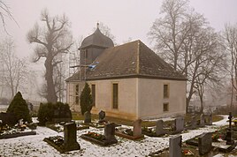
Ev. Thalborn Church
|
||
Thalborn is a district of the rural community Am Ettersberg in the Weimarer Land district in Thuringia .
location
The village is located north of Vippachedelhausen in the Thuringian Basin in the middle of the Feldmark in a green erosion channel. State road 1054 passes to the south .
history
The village was first mentioned on January 12, 1326. According to information from the Berlstedt administrative community , no written certificates have survived until 1637. That year, in the middle of the Thirty Years' War , the place was ransacked and many people died. There was a manor or manor in the village: on the grave slab there is talk of a gentleman from Thalborn , the foundation plaque also mentions a Volckmar Happe, ictus heir of Thalborn and Ehringsdorf . The property was demolished in September 2013. From the middle of the 17th century the noble place belonged to the office of Großrudestedt , which was part of the Duchy of Saxony-Eisenach from 1672 and came to Saxony-Weimar-Eisenach in 1741 . Since 1850 the place belonged to the administrative district Weimar of the Grand Duchy of Saxony-Weimar-Eisenach.
Thalborn used to be a linen weaver village . In 1731 there were 12 linen weavers, 4 stocking weavers a . a. Napoleon's troops passed through the place in 1813. The settlement was dominated by agriculture with large and medium-sized peasant ownership under the rule of the large manor there, which in 1880 still comprised 118 hectares. In 1913 the place was connected to the electrical supply.
Thalborn has a community-owned restaurant with a hall, which was built by the residents at the beginning of the GDR by the National Building Organization (NAW) and inaugurated in the late 1980s.
With the support of residents and local companies, the VW bus friends Thalborn organized a large VW bus meeting in Thalborn from April 30 to May 3, 2009 with visitors from several federal states and from overseas.
In 2009, 120 people lived in the district.
Attractions
- Christ Church : The massive hall church stands on the northern slope of the White Mountain ( 241 m ) south of Thalborn. As can be seen from a stone plaque next to the main entrance, it was built in 1686. The interior is defined by a uniform wooden barrel vault and the surrounding gallery on Tuscan columns . The church is a listed building. Renovation work is currently being carried out on the church (2012/13/14). The church is possibly on the spot where the grave of a Germanic prince was once found.
Web links
Individual evidence
- ^ Wolfgang Kahl : First mention of Thuringian towns and villages. A manual. 5th, improved and significantly expanded edition, new edition. Rockstuhl, Bad Langensalza 2010, ISBN 978-3-86777-202-0 , p. 283.
- ^ History of the community of Vippachedelhausen. History of the Thalborn district ( memento of November 29, 2014 in the Internet Archive ). In: vg-berlstedt.de, accessed on July 4, 2020.


