Saaleplatte
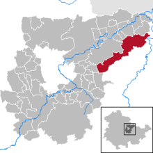
Saaleplatte was a municipality in the east of the Weimarer Land district . The fulfilling municipality for the municipality of Saaleplatte was the city of Bad Sulza , from December 31, 2013 until its dissolution on December 31, 2019.
Community structure
The community was divided into nine districts:
- Eckolstädt ,
- Grossromstedt ,
- Hermstedt ,
- Kleinromstedt ,
- Kosnitz ,
- Münchengosserstädt ,
- Pfuhlsborn ,
- Stobra and
- Wormstedt .
The merger took place on March 15, 1996.
geography
Geographical location
The municipality of Saaleplatte was in the east of the Weimarer Land on the Ilm-Saale-Platte , a plateau between the rivers Saale and Ilm at an altitude of 301 m above sea level. NHN. It last had 2870 inhabitants (as of December 31, 2018) on an area of 42.83 km². The country roads 1060 led through the municipality from Apolda to Jena, the L 1059 from Apolda to Camburg and the L 2160 from Utenbach to Dornburg. Further district roads connected the districts with one another. The next federal highways are the B 7 in the southwest, the B 87 in the west and the B 88 in the east. The next motorway is the A4 south of Jena.
landscape
The landscape is characterized by the wide, fertile arable land of the plateau. In the lowlands there are meadows, in a few steep or damp places there are small forests. In the east, on the slopes towards the Saale valley, the terrain becomes steeper. There are meadows and orchards or larger forest areas. The highest elevations are the heights northwest of Eckolstädt with almost 300 m above sea level. NN and the wooden corner south of Kleinromstedt with 352 m.
geology
The municipality belonged almost exclusively to the Upper Muschelkalk . To the east, it is overlaid by fertile loess to a large extent . Occasionally gneiss or other Nordic rocks are found as relics of the Elster Cold Age . In the west there are also larger areas of the lower Keuper , mainly the Kohlenkeuper. In the lowlands, the brooks created floods.
Waters
Several small streams flowed through the municipality, to the east to the Saale or to the west to the Ilm. The largest is the Utenbach , which rises east of Wormstedt and flows further west through Wormstedt and Utenbach and then to the north of the Ilm. The so-called Utenbach fish ponds lie along its course between Wormstedt and Utenbach . Other small streams are, for example, the Angergraben near Kleinromstedt, the Hermnitzgraben near Utenbach and the Hahngraben near Kösnitz.
history
→ The history of the individual districts is dealt with in the respective local articles.
The municipality of Saaleplatte was created on March 15, 1996 through the amalgamation of the nine villages that had previously been part of the administrative community of Ilm-Saale-Platte . Wormstedt was the municipality seat.
On December 31, 2019, the community was incorporated into the city of Bad Sulza .
Prehistory and early history
All parts of the community only acquired the same administrative affiliation after 1918, but look back on a common prehistory and early history. Due to its favorable soil and water conditions, the Saale-Ilm-Platte has been populated almost continuously since the Neolithic. The following cultures and periods of settlement can be identified within the community and in its neighboring towns: linear ceramic tape (5500–4900 BC), stitch ribbon ceramic (4900–4500 BC), Rössen culture (4500–4300 BC), spherical amphora culture ( 3100–2700 BC), corded ceramics (2800–2200 BC), bell beaker culture (2600–2200 BC), Aunjetitz culture (2300–1500 BC), burial mound culture (1600–1300 BC ) Chr.), Urnfield Culture (1300–800 BC), Hallstatt D (650–475 BC), Latène (480–0 BC), Roman Empire (0–400 AD), Migration period (AD 400–600).
In the early Middle Ages, at the time of the Frankish-German colonization in the east , today's settlement structures developed. Along the Alte Leipziger Straße , an important long-distance traffic route between the Thuringian Basin and the Leipzig lowlands, new farming villages were gradually founded. A presumably older Frankish settlement coming from the west (place names ending in –stedt or –städt ) was probably followed in the 9th and 10th centuries by a Slavic settlement originating from the east (Slavic place names: Stobra, Kösnitz and numerous desolations). The type of settlement of the Rundlingdorf , which is particularly typical for German-Slavic penetration zones, has been preserved in some places.
The region was fiefdom , isolated, however, the imperial monasteries acquired Fulda and Hersfeld and the Archdiocese of Mainz possessions. In the late Middle Ages (14th century) almost all districts came under the Wettin rule and became part of the offices of Dornburg , Camburg or Kapellendorf .
Development of the population
|
|
|
|
politics
Former mayor
The last mayor of the community was Jörg Hammer.
Culture and sights
- Stobra as a listed round village
- Rectory with forester memorial in Münchengosserstädt
- Local history museum in Eckolstädt
- Heimatstube in Hermstedt
- The village church Eckolstädt
Personalities
- Friedrich Christoph Förster , poet, was born on September 24, 1791 in the vicarage of Münchengosserstädt as the son of the local pastor
- Ernst Förster , German painter and art historical writer, brother of Friedrich Förster, was born on April 8, 1800 in Münchengosserstädt
- Alfred Ruppe , father of Hugo Ruppe , founder of the automobile company A. Ruppe und Sohn , was born in Kösnitz in 1829
literature
- A. Zahn: Ownership in and around Eckolstädt in the 14th century. In: Between Saale and Ilm 3 (9/2010), pp. 7-11
Web links
Individual evidence
- ^ StBA: Changes in the municipalities in Germany, see 1996
- ↑ Thuringian Law and Ordinance Gazette No. 11/2019 of October 18, 2019, p. 385 ff. , Accessed on January 5, 2020
- ^ H. Rhode: The field as a historical archive. A booklet accompanying the prehistoric and early historical collection in the Stiebritz Heimatmuseum , Stiebritz 2012
- ↑ a b c d Thuringian State Office for Statistics
