
Administrative community Kranichfeld
| coat of arms | Germany map | |
|---|---|---|
 Help on coat of arms |
Coordinates: 50 ° 51 ' N , 11 ° 12' E |
|
| Basic data | ||
| Existing period: | 01/01/1992– | |
| State : | Thuringia | |
| County : | Weimar Country | |
| Area : | 68.05 km 2 | |
| Residents: | 6258 (Dec. 31, 2019) | |
| Population density : | 92 inhabitants per km 2 | |
| License plate : | AP, APD | |
| Association key : | 16 0 71 5007 | |
| Association structure: | 6 municipalities | |
| Association administration address : |
Alexanderstr. 7 99448 Kranichfeld |
|
| Website : | ||
| Chairman : | Fred crowd | |
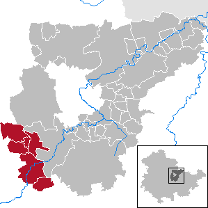
| Location of the Kranichfeld administrative community in the Weimarer Land district | ||
  |
||

The Verwaltungsgemeinschaft Kranichfeld is an amalgamation of the city of Kranichfeld and five municipalities in the Weimarer Land district in Thuringia , Germany . Its administrative seat is the eponymous city of Kranichfeld.
Approx. 6200 inhabitants live in the administrative community on an area of 68.05 km². It is located in the extreme southwest of the district and borders the state capital Erfurt in the northwest , the Ilm district in the west and the Saalfeld-Rudolstadt district in the south .
The chairman of the administrative association is Fred Quantity.
The municipalities
history
The administrative community was founded on January 1st, 1992.
Web links
Individual evidence
- ^ Population of the municipalities from the Thuringian State Office for Statistics ( help on this ).

existing: Kranichfeld | Mellingen
former: Bad Sulza | Berlstedt | Buttelstedt | Grammetal | Ilm-Saale-Platte | Ilmtal Wine Route | Isseroda | Kleinromstedt | Northern district of Weimar | Tröbsdorf | Wormstedt