Wickerstedt
|
Wickerstedt
Rural community of Bad Sulza
Coordinates: 51 ° 3 ′ 34 ″ N , 11 ° 32 ′ 37 ″ E
|
|
|---|---|
| Height : | 154 m above sea level NN |
| Area : | 8.48 km² |
| Residents : | 734 (Dec. 31, 2013) |
| Population density : | 87 inhabitants / km² |
| Incorporation : | December 31, 2012 |
| Postal code : | 99518 |
| Area code : | 03644 |
|
Location of the district in the rural community Bad Sulza
|
|
Wickerstedt is a district of the rural community of town Bad Sulza in the northeast of the county Weimar area .
location
Wickerstedt is located on the Ilm and the Aue northeast of the city of Apolda and southwest of the city of Bad Sulza . There is a connection to the federal highway 87 , which runs to the northwest .
history
For the first time Wickerstedt was mentioned in the 9th century as "Wigerestat" ("the settlement of the man Wicker / Wigges") as a Saxon settlement. Other spellings were "Wiegerestete" (around 874), "Wickerstette" (1063) or "Wigherstete" (1174). Variants with "Wigker-", "Wyckir-", "Wiker-" or "Wikirstete" are also known, whereby the term "wig" in Old High German also means "fight" (see also Wighard ).
In 1434 the castle in Wickerstedt was destroyed and as a result the local knight dynasty died out in 1505.
On 9/19 August 1719 (there are two different sources) a major fire destroyed 111 houses in the village. The church, parish, school as well as the brewery and bathhouse were also destroyed by the flames. According to the "Geographical and Historical Handbook of Regional, Ethnic and State Studies" from 1787, the village already consisted of 130 houses at that time, so one can assume that it was almost completely destroyed. The total material damage amounted to 50,592 guilders.
Further fires were recorded for October 24, 1812, June 12, 1818, July 24, 1842 with 17 burned down houses and for August 28 and 29, 1851 with 50 burned down buildings. The cause of the latter was a lightning strike.
The place belonged since the middle of the 15th century to the Ernestine Office Roßla , which in 1572 to Saxe-Weimar , 1603 to Saxe-Altenburg , 1672 again to Saxe-Weimar and 1741 to Saxe-Weimar-Eisenach . During the administrative reform of the Grand Duchy of Saxony-Weimar-Eisenach, the place came to the administrative district Weimar II ( administrative district Apolda ) in 1850 .
On December 31, 2012 the municipality of Wickerstedt was incorporated into the city of Bad Sulza together with other municipalities.
Population development
Development of the population (from 1994 December 31st) :
|
|
|
|
|
Data source 1847: “Weimar's oddities then and now”
Data source 1859 and 1910: State manual for the Grand Duchy of Saxony-Weimar-Eisenach
Data source 1877: Library of the entire commercial
sciences Data source 1994 to 2011: Thuringian State Office for Statistics
Data source from 2013: Website of the city of Bad Sulza
Attractions
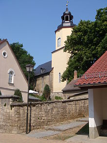
- The village church of St. Vitus is a baroque hall church with a stucco decoration and a historical organ.
- former inn, main street
- Homestead (parish), Hauptstrasse 12, with a memorial plaque for Gustav Adolf Keferstein
- House and gate, Hauptstrasse 23
- Residential building, Hauptstrasse 33
- former brewery with vaulted cellar, Hauptstrasse 38/40
- Mühlenhöft Obermühle Wickerstedt (former watermill), Hauptstraße 47a
- Front door and frame, Hauptstrasse 57
- Residential building, Hauptstrasse 63
- Courtyard, Mittelstrasse 24
- Ilm bridge at the exit to Flurstedt
- War memorial
Personalities
- Laurentius Niska (1590–1665), author of woad cultivation
- Johann Heinrich Vulpius (1599–1663), pastor
- Johann Bielcke (1643–1707), printer, bookseller and publisher
- Gustav Adolf Keferstein († 1861), pastor, educator and music writer


