
Mattstedt
|
Mattstedt
Rural community of Ilmtal-Weinstrasse
Coordinates: 51 ° 3 ′ 17 ″ N , 11 ° 30 ′ 17 ″ E
|
|
|---|---|
| Height : | 160 m above sea level NHN |
| Area : | 4.92 km² |
| Residents : | 499 |
| Population density : | 101 inhabitants / km² |
| Incorporation : | December 31 2013 |
| Postal code : | 99510 |
| Area code : | 03644 |
 Location of Mattstedt in Ilmtal-Weinstrasse
|
|
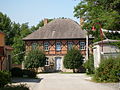
 Mattstedt (2009)
|
|
Mattstedt is a district of the rural community Ilmtal-Weinstrasse in the northeast of the Weimarer Land district .
history
The first part of the name comes from the Slavic ( Wengen tribe ) mät , which means something like "mow, mowed". Instead of, stedt means place or central place, which indicates a time of origin in the 3rd or 4th century. Old church registers refer to a noble family that bore the name Matstat , Mattstedt , Mattstete or Matstetten . These were Popo or Poppo de Matstete, mentioned on May 20, 1295 and March 13, 1298, Adalbertus de Matstete, mentioned 1225–1228, Otto called Saxo de Matstete, mentioned 1306, and Heinrich von Matstede, mentioned on May 9, 1323 North of Mattstedt there is a deserted area called Stedten . The parcel is still called that today.
Around 1000 the construction of the Mattstedter Marienkirche began. The place was first mentioned in documents in 1218, when it was donated to the Heusdorf monastery by Landgrave Albrecht Vitzthume von Apolda. In the State Handbook of the Grand Duchy of Saxony-Weimar-Eisenach from 1840 and 1848, Matstat is even mentioned for 1216. From 1262 to 1307 Mattstedt was the seat of Gunther von Schlotheim - Truchseß von Matstete and his family. The oldest house in the village (property no. 130 - today: Unterdorf 130) was in their possession. Even today there are remains of the old secret passage to the Heusdorf monastery under the cellar of the stable. Later it belonged to the Count of Orlamünde and from the 14th century to those of Kefernburg . Since 1437 the fief of Vitzthume von Rossla is occupied.
Mattstedt belonged to the Ernestine Office Roßla since the middle of the 15th century , which in 1572 came to Saxe-Weimar , 1603 to Saxe-Altenburg , 1672 again to Saxe-Weimar and 1741 to Saxe-Weimar-Eisenach . During the Thuringian Flood on May 29, 1613, the water level of the Ilm rose 6 m above normal. The entire lower village was flooded and largely destroyed. The carp ponds, of which the name Karwiese has been preserved, also disappeared. In this respect, the current village structure is a new settlement in the middle and upper village on the Mattstedter Platte .
In 1634 Swedish troops marched through the village in the Thirty Years' War and plundered the surrounding farms and the parish that they used as quarters. The church, which was razed at the time, was rebuilt in 1709 with the long nave still preserved today. This was made possible by the residents' own resources with the approval of the Duke of Saxony-Weimar and two documents of approval for the collection of money by the Weimar senior consistorial councilor and general superintendent as well as the local pastor Ernst Musäus from 1707. The leather-bound collector's book with a green ribbon is preserved in the church archive. The name of the collector, who was on the road for two years, has not been passed down.
For a short time there was coal mining in 1799 by pastor Wilhelm Christoph Günther with and on behalf of Grand Duke Carl August and August Karl von und zu Egloffstein , who was in the service of the Grand Duke. Goethe, a friend of Günther, also visited the place for this purpose; mainly because of the fossils contained in the 'Lettenkohle'. Because of the poor quality of the coal, mining was stopped in 1801 after 12,000 bushels had been mined. Only the district of Poche remained as a new work. However, this name was only created after the mining activities ended. In the subsequent use until 1806, still usable raw materials such as sulfur , vitriol and ammonium were obtained from the overburden by breaking open the tubers, "pounding" them. The street inn and former horse changing yard "Zur Poche" is still preserved in the district today. The financial and structural influence of Goethe in the rebuilding of the rectory, which is quite complex for a small community, in which Pastor Günther lived in Weimar until his successor Herders in 1801, has only been passed down and has only been documented by subsequent local pastors. It is documented that Goethe had the Ilmbrücke on the Poche repaired and had the Leipziger Straße, one via popularis , expanded to the Chaussee (today's federal highway 87 ) so that it could withstand the additional burden of the coal transport for 120 years. Günther was honored with a medal by Goethe in 1824 for his development work in relation to mining.
Also in 1806 soldiers moved through Mattstedt: fleeing Prussians and the advancing Napoleonic troops of Marshal Louis-Nicolas Davout after the battle of Jena and Auerstedt . During the administrative reform of the Grand Duchy of Saxony-Weimar-Eisenach, Mattstedt came to the administrative district Weimar II ( administrative district Apolda ) in 1850 and to the state of Thuringia in 1920.
On December 31, 2013 Mattstedt was incorporated into the new rural community of Ilmtal-Weinstrasse.
coat of arms
Until 1866, the residents of the neighboring municipality of Zottelstedt had to use the Mattstedt Bridge over the Ilm in order to get to Apolda or to cross the Ilm, due to the lack of their own bridge. Customs always had to be paid for using the paths and the bridge. This circumstance caused a discord between the two villages up to the present day. In order to take the pride of their bridge into account, Mattstedt (and partly again today) had a coat of arms showing the old bridge over the Ilm, which the "Biedermann" crosses from right to left, a man in a long carter's smock and with him Cylinder on his head, in hand he carries a stick or a carter's crop. The color scheme has not been passed down, but is used today in the color scheme shown. The original version in the still-preserved seal showed a figure of a saint with a staff cross on the bridge. A representation of St. Christopher or Nepomuk is assumed .
The coat of arms of the Lords of Mattstete showed in the 12th / 13th Century 2 turned goosenecks in the shield, above a shield cover with turned helmet; above it another right-turned gooseneck.
religion
29% of the population are Protestant, 1% Catholic. The Protestants including the Mattstedter Marienkirche belong to the Evangelical-Lutheran Johannisgemeinde Niederroßla in the parish of Apolda-Buttstädt of the Evangelical Church in Central Germany . The few Catholics belong to the parish of St. Bonifatius in Apolda , Diocese of Erfurt .
Attractions
- Marienkirche (bell tower restored in 2006 - for the first time since 1636 with three bells, including the newly cast Marienglocke) with historical altar, organ (around 1800) and frescoes as well as rectory
- Manor

Marienkirche

Chancel of the Marienkirche
Rectory

Memorial plaque for Pastor Wilhelm Christoph Günther

Foundation stone of the rectory with the inscription 1666 (which could also be read as half 8, then 1444)

old coat of arms Mattstedt, Thuringia 1885

Coat of arms of the Lords of Mattstede according to local history


Culture, tourism, associations
Mattstedt has a cultural center where concerts ( Biba and the Butzemänner ) and festivals take place on a regular basis , such as the "Ilmrock Festival" or the "Folk Festival". The Apolda breed shows for the world-famous Doberman and the Bernese Mountain Dogs are also held there.
In the former Mühlengut (Obermühle), a privately organized, Europe-wide known tango festival takes place several times a year . Because of the high number of international visitors, the cultural center has been used since 2013.
In addition to the fire brigade association and the homeland association, the association "Children of Chernobyl", which operates throughout Thuringia, was involved in Mattstedt until 2008. Since the disaster in 1986 , one or two groups of children have been accommodated here annually for several weeks in the old school and in host families for recreation. The association was mainly financed by donations.
The Ilmradwanderweg, which comes from Ilmenau via Weimar and leads to the mouth of the Saale ( Großheringen ), leads through Mattstedt .
A section of the old Via Regia (Königsstraße) also leads south of Mattstedt, coming from Weimar, to Eckartsberga . Parallel to this, the Altstrasse (Flur Grenzweg) Weinstrasse , a Via Pastoralis (Kirchenstrasse), leads in the north from Mainz into the former settlement area of the Wengen. The name Weinstraße does not come from wine, but from the original name Via Wintwich , i.e. Wendenstraße. The Slavic 'Wirit' became 'Win' and later the German 'Wein'. Today's "Leipziger Straße" ( B 87 ) was only a Via Popularis , an unprotected street for the common people , until it was expanded in the 18th century .
For August 25, 2018, right-wing extremists had announced a right-wing rock concert advertised throughout Germany on a former industrial site in the town, but the Apolda district court prevented the use of this area a few hours before the start of the event . Regardless of this, the democracy festival organized by citizen groups and associations took place anyway. a. The Thuringian Prime Minister Bodo Ramelow and Interior Minister Georg Maier also participated.
economy
- several medium-sized companies
- private smallholders with approaches to organic farming
- Main agricultural use by the Rannstedt agricultural cooperative
- large industrial ruin : former dye works, then Lacufa (lacquers and paints), reprivatised after the fall of the Wall, later bankruptcy
Personalities
Honorary citizen
- Ken Roczen , appointed October 14, 2011
- Elke Röcker , appointed October 3, 2013
sons and daughters of the town
- Walter Tröge (1888–1955), writer of military history and racist publicist
- Christine Laser born Bodner (* 1951) in Mattstedt, former German athlete, ( pentathlete ), married to Jürgen Laser , 1973 German champion (GDR) in 400 m hurdles
- Ken Roczen (* 1994), motocross racer
People connected to the place
- Wilhelm Christoph Günther (1755–1826), theologian, author of children's fairy tales, later court and garrison preacher and senior consistorial councilor in Weimar, married Johann Wolfgang von Goethe (1749–1832) and Christiane Vulpius (1765–1816) in Weimar in the Jakobskirche in 1806
- Johann Friedrich Gottlieb Köhler , theologian (pastor from 1821–1855) and writer
Web links
Individual evidence
- ↑ Otto Franke (Ed.): The Red Book of Weimar (= Thuringian-Saxon History Library . Vol. 2, ZDB -ID 844945-4 ). Perthes, Gotha 1891, p. 62 f.
- ^ Constantin Kronfeld: Regional Studies of the Grand Duchy of Saxony-Weimar-Eisenach. Part 1: Thuringian-Saxon-Weimar history. Böhlau, Weimar 1878, p. 183 ; Part 2: Topography of the Land. Böhlau, Weimar 1879, p. 201 .
- ^ Julius C. Kronfeld: History and description of the factory and trading town of Apolda and its immediate surroundings. Teubner, Apolda 1871, p. 102 .
- ↑ Carl Chl. von Reitzenstein: regests of the counts of Orlamünde from the Babenberger and Ascan tribe. Historical Association for Upper Franconia, Bayreuth 1871, p. 109 .
- ^ Wilhelm Rein: Thuringia sacra. Volume 1: Ichtershausen Monastery. Böhlau, Weimar 1863, p. 186 .
- ^ Wilhelm Rein: Thuringia sacra. Volume 1: Ichtershausen Monastery. Böhlau, Weimar 1863, p. 130 .
- ^ Wilhelm Rein: Thuringia sacra. Volume 1: Ichtershausen Monastery. Böhlau, Weimar 1863, p. 190 .
- ↑ Carl Chl. von Reitzenstein: regests of the counts of Orlamünde from the Babenberger and Ascan tribe. Historical Association for Upper Franconia, Bayreuth 1871, p. 18 .
- ↑ Thomas Waschke: Wüstungen in the Apolda district. In: Apoldaer Heimat. Vol. 3, 1985, ISSN 0232-8992 , pp. 26-27.
- ^ Johann EA Martin (Ed.): Document book of the city of Jena and its spiritual institutions. Volume 1: 1182-1405 (= Thuringian historical sources . NF Vol. 3, 1 = Vol. 6, 1, ZDB -ID 548596-4 ). G. Fischer, Jena 1888, No. 310 , u. ö.
- ^ State manual of the Grand Duchy of Saxony-Weimar-Eisenach. 1840, ZDB -ID 514527-2 , p. 156 and 1848, p. 180.
- ^ Werner Eckart: Small Ortschronik von Mattstedt. In: Apoldaer Heimat. Vol. 3, 1985, pp. 19-22, here pp. 20-22.
- ↑ Andreas LJ Michelsen : Documented exit of the county Orlamünde. Mainly based on documents from the Hofmann-Heydenreich manuscript. Frommann, Jena 1856, p. 31 .
- ↑ Thvringia Sacra, Sive Historia Monasteriorvm, Qvae Olim In Thvringia Florvervnt. Weidmann, Frankfurt am Main 1737, pp. 337 , 375 , 394 .
- ^ Wilhelm Rein: Thuringia sacra. Volume 1: Ichtershausen Monastery. Böhlau, Weimar 1863, in several places.
- ^ August Schumann : Complete State, Post and Newspaper Lexicon of Saxony. Volume 6: Lohmen to Neudörfchen. Schumann, Zwickau 1819, p. 188 .
- ↑ Carl Fr. Ludw. Schumann: Weimar-Eisenach regional studies. Wagner, Neustadt ad Orla 1836, p. 88 .
- ↑ Johann Gottlob Samuel Schwabe (Ed.): Historical news of the numerous monuments and relics of D. Martin Luther located in the Grand Duchy of Saxony Weimar-Eisenach. Hoffmann, Weimar 1817, p. 152 .
- ^ State manual for the Grand Duchy of Saxony-Weimar-Eisenach. 1864, p. 197, 11 .
- ↑ Legendary things from Apolda and the surrounding area. EURA-WKA-Concepts acc. eV, Erfurt 1998, ISBN 3-933408-01-6 , pp. 33 and 34.
- ↑ StBA: Area changes from January 1st to December 31st, 2013
- ^ J. Siebmacher's large and general book of arms in a new, fully organized edition. Volume 1, Section 4: City Arms. Volume 2 = delivery 10–19. Bauer and Raspe, Nuremberg 1885, p. 311 , plate 299 .
- ↑ Legendary things from Apolda and the surrounding area. EURA-WKA-Concepts acc. eV, Erfurt 1998, ISBN 3-933408-01-6 , p. 27 ff.
- ↑ census database .
- ^ Thomas Waschke: Old streets in Apolda - the wine route. In: Apoldaer Heimat. Vol. 7, 1989, pp. 24-25.
- ↑ Apoldaer Allgemeine August 24, 2018