Hohestein
| Hohestein | ||
|---|---|---|
|
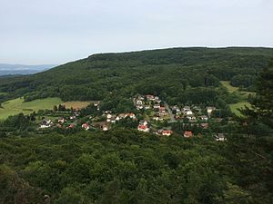
View from the Pferdeloch over Hitzelrode to the Hohestein |
||
| height | 569 m above sea level NHN | |
| location | at Hitzelrode ; Werra-Meißner-Kreis , Hessen ( Germany ) | |
| Mountains | Gobert , Thuringian Basin (with edge plates) | |
| Coordinates | 51 ° 14 '58 " N , 10 ° 2' 25" E | |
|
|
||
| rock | Shell limestone | |
| particularities | Landslide area in Hessian Switzerland near Meinhard | |

The Hohestein is 569 m above sea level. NHN the highest mountain of the Gobert . It is located near Hitzelrode in the Werra-Meißner district of Hesse ( Germany ). Part of the landslide area of Hessian Switzerland near Meinhard spreads out on the mountain .
geography
location
The Hohestein rises in the northeast of the Werra-Meißner district, the state border with Thuringia and thus the former inner-German border runs over its northeastern branch. Its summit is 1.5 km northwest of Hitzelrode , 1.6 km north of Motzenrode , 4.3 km north-northeast of Jestädt , 3.6 km northeast of Albungen and 3.2 km east of Kleinvach , all of which are in Hesse, and 3.5 km south-southeast of Asbach and 2.8 km west-southwest of Volkerode , both of which are located in Thuringia. It is 7 km to the south-southeast to the center of the district town of Eschwege , and that of the city of Bad Sooden-Allendorf is 5.3 km to the west-northwest - both in Hesse.
The Hohestein extends from the main ridge of the Gobert in the border area to the Thuringian Eichsfeld in a westerly direction to the Werra loop near Kleinvach in Hessen. The Mühlbach (Motzbach) flows south past the Hohestein and the Hainbach flows northwards , both of which flow into the Werra .
Natural allocation
According to the natural structure in the Kassel sheet, the Hohestein belongs to the main unit group Thuringian Basin (with edge plates) (No. 48), in the main unit northwestern edge plates of the Thuringian Basin (483) and in the subunit Allendorfer Wald (483.1) to the natural area Gobert (Goburg ) (483.10). According to the classification of the BFN , this part of the mountainous region is also included in the Lower Werrabergland .
Nature and protected areas
The Hohestein is completely forested. Its region is part of the alpine landslide and nature reserve Hessian Switzerland near Meinhard ( CDDA no. 163663; designated 1989; 2.4167 km² in size), which is mostly just called Hessian Switzerland . Parts of the fauna-flora-habitat areas Werra and Wehre valley (FFH no. 4825-302; 244.8191 km²) and limestone cliffs of the Gobert (FFH no. 4726-350; 2.8922 km²) are located on the mountain and the rock cliffs bird sanctuary in the Werra-Meißner district (VSG no. 4726-401; 4.8343 km²).
Traffic and walking
Far south-south-west of the Hohestein, the B 249 branches off to the east between Jestedt and Niederhone from the federal road 27 running in the Werra valley . From the latter, the state road 3403 leads from Niederhone through Jestädt and Motzenrode northeast to Hitzelrode. There it turns into Landesstraße 3424, which runs south through Neuerode and Grebendorf to Eschwege. There are parking spaces for hikers in the Motzen- and Hitzelrode. The mountain is popular as an excursion and hiking area with a varied landscape. The European long-distance hiking trail E6 and the 15.5 km long premium trail Hessian Switzerland lead across . From its western foothills Hörne ( 522.7 m ) and its southern foothills Hohe Bahn ( 509.6 m ) as well as from the beautiful view (approx. 520 m ) there are views of the Lower Werra Valley and the north-east Hessian mountainous region.
Web links
Individual evidence
- ↑ a b c Map services of the Federal Agency for Nature Conservation ( information )
- ^ Hans-Jürgen Klink: Geographical land survey: The natural space units on sheet 112 Kassel. Federal Institute for Regional Studies, Bad Godesberg 1969. → Online map (PDF; 6.9 MB)
- ↑ Premium path P4 Hessian Switzerland on naturparkfrauholle.land

