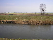
Gera-Unstrut-Helme-Niederung
The Gera-Unstrut-Helme-Niederung is a low and floodplain landscape in the northeast and in the middle of Thuringia and in the southwest of Saxony-Anhalt ( Germany ).
The area lies between the Harz Mountains in the north and the Thuringian Forest in the south and, according to the handbook of the natural spatial structure of Germany, belongs to the receiving waters of the Thuringian Basin and its edge plates .
Geographical location
The Gera - Unstrut - Helme lowland extends along the rivers of the same name in the districts of Nordhausen , Sömmerda , Kyffhäuser , with a small proportion in the Unstrut-Hainich district and the city of Erfurt in Thuringia and in the district of Mansfeld-Südharz in Saxony-Anhalt. The largest cities are Erfurt on its southern edge , Nordhausen on the northwestern and Sangerhausen on the northeastern edge. Sömmerda and Artern are located directly on the Unstrut. The altitudes of the lowlands range from 170 m near Nordhausen and Gispersleben to around 115 m at the entrance of the Unstrut into the Unteren Unstrut plates near Memleben.
Natural classification
The landscape, which has a total area of approx. 528 km², represents the main unit 487 within the natural spatial main unit group Thuringian Basin (with edge plates) .
Classification according to TLUG
According to the purely inner- Thuringian classification, the natural areas of Thuringia of the Thuringian State Institute for Environment and Geology in Jena (TLUG) include the areas in Thuringia to the floodplains and lowlands :
- 6.1 Golden floodplain
- 6.2 Helme-Unstrut depression
- 6.3 Gera-Unstrut lowland
As in the BfN landscape profile, the eastern roofing of the Kyffhäuser Mountains is assigned to neighboring natural areas.
Partial landscapes
Gera-Unstrut lowland
South of the Sachsenburg gate, the lowland along the Gera, Unstrut and other tributaries ( Lossa , Helbe ) together with the hilly Keuperbeckens form the actual Thuringian basin . Larger landscapes here include the Great Ried near Gispersleben and the Unstrut-Lossa-Rieth near Leubingen .
Helme-Unstrut depression
Beyond the Unstrut breakthrough, wider low areas are formed again. Immediately to the north is the Diamantene Aue with the Esperstedter Rieth near Bad Frankenhausen and the Talaue called Das Ried near Artern. To the east, the Untere Unstrutrieth extends to Memleben . In the north, the Helmerieth forms the central part of the Golden Aue between the Harz and Kyffhäuser . The red sandstone elevations of the Haardt (186 m) and the Heide (at the Mittelkopf: 244 m) are enclosed in the lowlands of the Golden Aue .
Eastern roofing of the Kyffhäuser
The eastern roofing of the Kyffhäuser up to near the city of Artern is added to the natural area. It consists of red sandstone and reaches heights of up to 50 m above the valley meadows (vineyard: 182 m, Helmberg: 165 m).
Geology and nature
The lowlands were mainly formed by subsidence as a result of the leaching of the Zechstein and gypsum deposits underground; tectonic influences were also partly involved in the Helmen lowlands . The valleys were filled by the deposition of gravel from the mountain runoffs and form flat floodplains. In some places at the transition to the Zechstein, brine springs also come to light.
The flat valley floors are covered with alluvial clay and black earth. Because of the good soil, the lowlands are used entirely for agriculture, and in floodplain areas as grassland. There are only a few nature reserves here (for example at the Kelbra dam). On the other hand, larger bird sanctuaries near Straussfurt and Berga-Kelbra are significant .
Flood protection
Due to the low gradient and the large catchment area, the lowlands are strongly endangered by floods. For this reason, in addition to numerous smaller reservoirs in the surrounding area, larger flood retention basins were built at Straussfurt and Berga-Kelbra .
Individual evidence
- ^ E. Meynen and J. Schmithüsen : Handbook of the natural spatial structure of Germany - Federal Institute for Regional Studies, Remagen / Bad Godesberg 1953–1962 (9 deliveries in 8 books, updated map 1: 1,000,000 with main units 1960)
-
^ Walter Hiekel, Frank Fritzlar, Andreas Nöllert and Werner Westhus: The natural spaces of Thuringia . Ed .: Thuringian State Institute for Environment and Geology (TLUG), Thuringian Ministry for Agriculture, Nature Conservation and Environment . 2004, ISSN 0863-2448 . → Natural area map of Thuringia (TLUG) - PDF; 260 kB → Maps by district (TLUG)
- ↑ Map services of the Federal Agency for Nature Conservation ( information )


