Finn fault zone
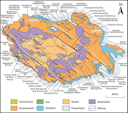
The Finne fault zone is a hercynian , ie from northwest to southeast running geological fault zone in northeast Thuringia and in the Burgenland district in southwest Saxony-Anhalt . It extends about 110 km from Sondershausen on the northeast flank of the Hainleite to Gera - Pohlen in the East Thuringian slate mountains .
The fault zone in particular forms the north-eastern edge of the Thuringian Basin into its edge plates and separates the main blocks of Hermundurian plaice (part of the Gera-Jáchymov zone ) in the north-east and Bleicherode – Stadtrodaer plaice in the south-west.
course
The Fin Fault Zone is divided into the Fin Fault in the northwest and the Camburg – Eisenberg – Geraer fault zone in the southeast, which consists of three further partial fault zones .
Finn disorder
The Finn Fault forms about half of the northwestern part of the Hercynian Fin Fault Zone. It begins at Sondershausen ( Kyffhäuserkreis ), on the steep northeast slope of the Hainleite , as a weak flexure , and only emerges beyond the Thuringian Gate , in the area of the Schmücke ( Sömmerda district ), as a clear fault , which jumps on its southeast edge to the northeast edge of the Finnberg -Kammes moved a little to the southeast.
While in the latter area the fault line roughly flanked the transition from Muschelkalk in the southwest to Buntsandstein in the northeast, in the southeast of the Finn between Rastenberg and Eckartsberga ( Burgenlandkreis ) the layer of shell limestone is almost completely absent and the fault line touches the Keuper of the Thuringian Basin directly to the southwest .
Only between Eckartsberga and Bad Sulza ( Weimarer Land district ), where a staggered arrangement of partial faults is typical, does a ridge of shell limestone come to light again. In the triangle of mouth between the Ilm and Saale , the actual Finns fault ends at the northern edge of the Jena plate . A short partial fault, which is noticeably shifted to the southwest, occurs at Camburg ( Saale-Holzland district ) in the Saale loop there.
Camburg – Eisenberg – Gera fault zone
The Camburg – Eisenberg – Gera fault zone comprises three spatially separated partial faults that continue the Hercynian line of the Finn fault (see above) from Camburg to the southeast to Gera - Pohlen .
The Frauenprießnitz faults are several parallel faults in the Saale-Holzland district in Thuringia , the main fault line of which extends from Wichmar via Frauenprießnitz to Schkölen - Poppendorf, offset from the southwest to the Finn fault . It separates the Poppendorfer Sattel in the northeast from the Tautenburger Wald in the extreme northeast of the Jenaer Platte , the northeasternmost part of the Ilm-Saale-Platte .
The Eisenberg fault , which continues for the most part in the Saale-Holzland district, but extends into the district of Greiz , is again clearly shifted to the northeast compared to the Frauenprießnitz faults and is thus roughly on the extension of the Finn fault line. It hardly touches the Jenaer Scholle and mostly runs in the Saale-Elster sandstone slab . Along its course, series of shell limestone merge into Middle Buntsandstein in the north-western part, and series of Middle Buntsandstein in Lower Buntsandstein in the southeast part. Between Gösen and Eisenberg , the fault consists of at least four parallel partial faults.
The line of Eisenberger disorder continuing in about 10 km away Pohlener disturbance south of the city of Gera and in the district of Greiz flanked one on the Elster passing red sandstone / Perm Trench on the eastern edge of the Gera valley to the northeast to Ronneburger transverse zone .
Individual evidence
- ↑ a b D. Franke: Regionalgeologie Ost - Geological online encyclopedia for East Germany
- ↑ a b Hydrogeological map of Thuringia from the Thuringian State Institute for Environment and Geology (PDF; 4.37 MB) ( Even finer maps are available for each district .)
Web links
- D. Franke: Regionalgeologie Ost - Geological online lexicon for East Germany
