Wieter
| Wieter | ||
|---|---|---|
|
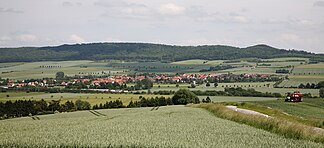
The southern Wieter with the highest peak and the Tockenberg east of Sudheim |
||
| Highest peak | Nameless summit ( 358.4 m above sea level ) | |
| location | District of Northeim , South Lower Saxony ( Germany ) | |
| part of | Göttingen-Northeimer Wald , Weser-Leine-Bergland | |
| Classification according to | Handbook of the natural spatial structure of Germany | |
|
|
||
| Coordinates | 51 ° 40 ′ N , 10 ° 0 ′ E | |
| rock | Shell limestone | |
The Wieter is up to 358.4 m above sea level. NN m high and in terms of area small mountain range of the Leinebergland in southern Lower Saxony ( Germany ).
geography
The Wieter is a ridge running in north-south direction immediately southeast of the district town of Northeim . It is about five kilometers long and a maximum of one kilometer wide. Other neighboring localities are the Northeimer districts of Hammenstedt in the northeast, Bühle in the south and Sudheim in the west. The Güntgenburg and Levershausen Vorwerke are also located directly to the east of the Wieter.
Natural allocation
The Wieter as part of the Lower Saxony mountainous region is assigned as follows:
-
(to 37 Weser-Leine-Bergland )
-
(to 373 Göttingen-Northeimer Wald )
- 373.0 Nörtener Wald (with Wieter and Langfast )
-
(to 373 Göttingen-Northeimer Wald )
The Wieter as part of the natural area of the same name north of the Nörten forest borders in the west on the Northeimer Leinegraben , in the north on the lower Rhumetal and in the east on the southeastern mountainous area of the Northeimer Stadtwald ( Semiskopf : 270.8 m, Großer Sandberg : 298.8 m).
nature
The wooded Wieter consists of a chain of hilltops arranged from north to south:
- Wieterberg (271 m)
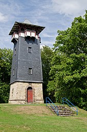
- nameless summit (326 m) with the Wieterturm
- Teufelsberg (315.2 m)
- the highest peak at 358.4 m
- Tockenberg (approx. 320 m)
The ridge belongs to the Northeimer Stadtwald within the LSG Westerhöfer Bergland-Langfast . In part it passed with Mittelwald . There is a high ropes course close to the city and the plan is to create a nature adventure trail starting from the Northeimer Forsthütte.
The nature reserve Mäuseberg and Eulenberg connects to its southern foothills .
history
The name was first mentioned in a document in 1305. It is based on the Old High German word witu , forest. Since it is a mountain range made up of at least six distinguishable but hardly noticeable hills, these are numbered consecutively by the local population. In the 19th century, the previously partially deforested mountains were reforested.
Individual evidence
- ↑ Map services of the Federal Agency for Nature Conservation ( information )
- ↑ Jürgen Hövermann 1963: Geographical land survey: The natural space units in single sheets 1: 200,000 - Federal Institute for Regional Studies, Bad Godesberg 1952-1991 → Online maps
- ↑ Stiftung Wald in Not supports a medium-sized forest project in the Northeimer Stadtwald ( memento of the original from March 4, 2016 in the Internet Archive ) Info: The archive link was automatically inserted and not yet checked. Please check the original and archive link according to the instructions and then remove this notice.
- ↑ Heinrich Leo: Rectitudines singularum personarum, 1842, p 87
- ^ Emil Jörns: City forester Friedrich Wieters, in: Northeimer Heimatblätter 1/1963, p. 18f


