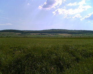
Ahlsburg (ridge)
| Ahlsburg | ||
|---|---|---|
|
North-east side of the Ahlsburg ridge |
||
| Highest peak | Sackberg ( 411.4 m above sea level ) | |
| location | District of Northeim , South Lower Saxony ( Germany ) | |
| part of | Solling foreland , Weser-Leine-Bergland | |
| Classification according to | Handbook of the natural spatial structure of Germany | |
|
|
||
| Coordinates | 51 ° 44 '46 " N , 9 ° 49' 12" E | |
The Ahlsburg in the southern Lower Saxony district of Northeim is up to 411.4 m above sea level. NHN high red sandstone - ridge in the Solling foreland , part of the Weser-Leine mountainous region .
geography
location
The Ahlsburg rises in the center of the Northeim district. The ridge lies south of the Ilme valley and forms a southern end of the Einbeck-Markoldendorfer basin . In a north-west-south-east direction, it extends south-south-west of Einbeck on the Ilme , west of the Leine valley, west-north-west of Northeim passed by the Leine , north-north-west of Moringen , north-east of Fredelsloh , east of Solling and south-east of Dassel and the Ellenser Forest . The wooded Ahlsburg is part of the urban and community areas of Dassel, Einbeck, Northeim and Moringen. It is around ten kilometers long and a maximum of three kilometers wide.
Natural allocation
The Ahlsburg is naturally allocated as follows:
- (to 37 Weser-Leine-Bergland )
- (to 371 Sollingvorland )
- 371.1 Southern Solling Foreland
- 371.12 Ahlsburg
- 371.1 Southern Solling Foreland
- (to 371 Sollingvorland )
mountains
The mountains and elevations of the Ahlsburg ridge include - with height in meters (m) above sea level (NHN):
|
|
Flowing waters
The rivers in and on the Ahlsburg ridge include (all in the Leine catchment area ):
- Bölle (rises on the southern edge of the ridge, passes its southern foothills and is a western tributary of the Leine)
- Dieße (rises on the eastern edge of the Solling, passes the western capping of the ridge and is a south-southwest tributary of the Ilme)
- Ilme (passes the ridge a little further north and is a western tributary of the Leine)
- Leine (passes the ridge a little to the east and is a southern tributary of the Aller )
- Rebbe (rises in the middle part of the ridge and is a southern tributary of the Ilme)
- Rotte (rises north of the ridge and is a southern tributary of the Ilme)
- Hane (rises in the middle part of the ridge and is a southern tributary of the Dieße).
Worth seeing
Among the attractions in and around the ridge Ahlsburg belong - with height in meters (m) above mean sea level (MSL):
- Grubenhagen Castle (298.0 m)
- Fredelsloh (approx. 270 m, artist and pottery village)
- Imperial oak (approx. 240 m)
- Quast beech (331 m)
- Steel beech (approx. 310 m)
- Bengerode desert (approx. 265 m, medieval pottery settlement).
Web links
References and comments
- ↑ a b Maximum height of the Ahlsburg ridge and name Sackberg according to an unknown source
- ↑ Göttinger Geographische Abhandlungen , editions 36–38, 1966, p. 110
- ^ Jürgen Hövermann: Geographical land survey: The natural space units on sheet 99 Göttingen. Federal Institute for Regional Studies, Bad Godesberg 1963. → Online map (PDF; 4.1 MB)
- ↑ a b c d e f g h i j k Topographic map with the Ahlsburg ( memento of the original from February 19, 2016 in the Internet Archive ) Info: The archive link was inserted automatically and has not yet been checked. Please check the original and archive link according to the instructions and then remove this notice. (DTK 25; for mountain heights see large enlargement of the map), on natur-erleben.niedersachsen.de
- ↑ a b c d e f g h Map services of the Federal Agency for Nature Conservation ( information )


