Ernst August Canal (Hanover)

The Ernst August Canal is a historic canal in the Hanover district of Herrenhausen . Johann Georg von Eckhart published the geological profile found during the construction of the canal in order to make known the historical model of the Protogaea by Gottfried Wilhelm Leibniz, which was still unprinted out of consideration for theology, in a neutral way.
description
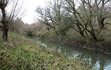
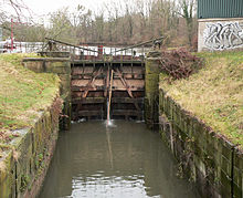
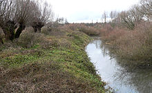
The width of the canal is three to five meters. It has a lock that is 60 meters long, 6.5 meters wide and 4 meters deep. The lock gates are 3.15 by 5 meters and are made of four cubic meters of oak. Next to the lock there is a weir to regulate the water level in the canal.
The Ernst August Canal begins between the Leine weir in Limmer and the Wasserkunst and ends after about 900 meters in the Leine. At the beginning there is a lock that was built around 1760, which replaced a first previous building from 1721, which never worked optimally.
The watercourse was dug as the Neuer Canal by soldiers between 1718 and 1720 to ensure the water supply for the water art in the Herrenhausen Gardens . A mound of earth lying on the route was dug up in 1717 and examined more closely. In the square elevation about 1.5 meters high, there were remains of masonry and a blackened plaster floor. The mayor of Hanover, Christian Ulrich Grupen, reported on this in his work Origines et antiqvitates Hanoverenses , published in 1740 . Today the survey is held for the castle stables of Limmer Castle, which according to tradition was the seat of the Counts of Roden in the 13th century .
meaning
Since the end of shipping on the leash at the beginning of the 20th century, the canal is no longer important.
The Ernst August Canal bridges the difference in altitude between the weir in Limmer and bypasses the subsequent course of the river, in which dangerous eddies form through the weir . In addition, he ensured the supply of the water features in the neighboring mansion palace garden .
As part of the preparation for the Expo 2000 in Hanover, the lock has been comprehensively renovated since 1996 in accordance with historical monuments . It was then functional again and was put into operation for demonstration purposes. It is not suitable for boat traffic by today's standards. The lock gates were operated by hand during demonstrations.
Others
In Hamburg-Wilhelmsburg there is an Ernst August Canal that connects the Reiherstieg with the Wilhelmsburger Dove Elbe .
literature
- Waldemar R. Röhrbein : Ernst August Canal and Lock. In: Klaus Mlynek, Waldemar R. Röhrbein (eds.) U. a .: City Lexicon Hanover . From the beginning to the present. Schlütersche, Hannover 2009, ISBN 978-3-89993-662-9 , p. 164.
Web links
- Brief description of the Ernst August Canal at hannover.de
Individual evidence
- ↑ JG Eckhart, description of what was found in the earth during the excavation of the Herrenhausen Canal on the Lein-Strome, New Newspapers from Scholars Things to the year 1719 No. 24, 185-192, see: Cornelius Steckner: Lügenstein und World archeology .
- ↑ a b c d Hannover.de: Station 7 - Wasserkunst, Leine and Ernst August Canal: Leibniz and the Fountain , accessed on September 1, 2018.
- ↑ a b c d e Citizen Information System City of Hanover , inserted on September 2, 2006 ( page no longer available , search in web archives )
- ↑ a b c d Ernst August Canal and Lock In: Klaus Mlynek, Waldemar R. Röhrbein (Ed.): Stadtlexikon Hannover , p. 164
- ^ Conrad von Meding: Presentation of the lake project "Leine-Bogen" , HAZ, September 22, 2010
- ↑ a b Horst Dralle: 1. Der Burghügel In: Die Burg Limbere , accessed September 1, 2018 (PDF, 242 kB)
- ↑ a b Christian Ulrich Grupen: Origines Et Antiqvitates Hanoverenses , pp. 3–8
- ^ Burg Limmer In: Klaus Mlynek, Waldemar R. Röhrbein (Ed.): Stadtlexikon Hannover , p. 100
- ↑ Stadtatlas-Greater Hamburg , PAS Verlags GmbH, Hamburg 2009, p. 51, ISBN 978-3-934272-92-7
Coordinates: 52 ° 22 ′ 54 ″ N , 9 ° 41 ′ 31 ″ E


