Lütgenrode
|
Lütgenrode
Patches Nörten-Hardenberg
|
||
|---|---|---|
| Coordinates: 51 ° 37 ′ 54 ″ N , 9 ° 54 ′ 31 ″ E | ||
| Height : | 143 (140-152.7) m | |
| Area : | 3.49 km² | |
| Residents : | 308 (2015) | |
| Population density : | 88 inhabitants / km² | |
| Incorporation : | March 1, 1974 | |
| Postal code : | 37176 | |
| Area code : | 05503 | |
|
Location of Lütgenrode in Lower Saxony |
||
Lütgenrode is a district of the Nörten-Hardenberg area in the Northeim district in Lower Saxony .
Geographical location
Lütgenrode is on the edge of the Leinegraben , west of the Nörten-Hardenberg patch, of which it is a district. The Espolde and the Ümmelbach , which flows into the Espolde at the eastern end of the village, flow through the area of the village . The highest point of the place is the Steinbühl at 152.7 m above sea level. NN. Neighboring villages are Parensen , Wolbrechtshausen and Behrensen .
history
Lütgenrode was first mentioned in a document in 1333 as Luttekerode. The name of the place is related to the creation of new arable land from forest areas ( clearing ), which was carried out at the time of the establishment in the area, as well as in the nearby place Großenrode . The name Lütgenrode can therefore be translated as " small clearing ".
At that time, the Lords of Hanstein sold the fiefdom in Lütgenrode to the Hardenberg family , who from then on ruled over the village. At that time, the Lords of Grone were also wealthy in Lütgenrode, as can be seen from the fact that they sold the tithe in Lütgenrode to the St. Petri Abbey in Nörten-Hardenberg on May 1, 1385 , and the following year the Lords of Grone sold the monastery another 3 hooves , of the place. The property of the Nörtener Petersstift continued to grow into the 18th century, so the Nörtener dean Kannemann reports in 1740 of 4 or 2 hoofs of Meierhöfen , a tithe of 40 acres , a piece tithe and 7½ acres of Fladenland. For the use of the flatbread land, St. Peter's monastery committed itself to consecrate the flatbreads, small, round cakes with a coating of eggs and honey, at Easter. In 1683 and 1706 the extent of the flat land was lent to a certain Molthan for 6 years in exchange for an annual donation of 3 bushels of rye or oats.
In the 15th century the village fell victim to feuds . In a period of only six years, the site burned down almost completely in two attacks.
But even after that, at the time of the Reformation, the conflicts in the village were not over. This was due to the fact that Lütgenrode and other villages under the influence of the Hardenberg family converted to the Protestant faith much faster than their masters. Such an ecclesiastical split took place in which the Lütgenröder first felt they belonged to the Reformed Church of Parensen, which was already reformed in 1542 , but later turned to the Marienstein Monastery when it realigned its faith. Formally, however, Lütgenrode still belonged to the parish of Nörten , which reserved the right to carry out church activities in the village until 1808. After the First World War, Lütgenrode was reassigned to the church in Parensen. An affiliation that still exists today.
From the 19th century the place continued to develop peacefully and everyday agricultural life shaped people's lives. However, in the course of industrialization , more and more people found work in the nearby factories.
On March 1, 1974, Lütgenrode was incorporated into the Nörten-Hardenberg area.
St. John's Chapel
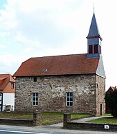
Above the Espolde is the Evangelical Lutheran Chapel of St. Johannis. Its history can be traced back to the time the town was founded in the 14th century. At that time it was built as a fortified chapel and therefore, until its partial destruction in a feud in 1484–1486, it also served as a shelter and storage room in addition to its ecclesiastical function.
During the reconstruction, which, according to the inscription, can be dated to 1592, the building was extended to the west, which can still be seen today in the middle of the longitudinal wall through a construction seam with pronounced corner cubes as an eastern boundary. The eastern part of the church was about a length. 7.6 m and several floors. This is supported by the wall notches, which are at the height of the current ceiling, 5.15 m above the floor. The first floor was once located at this height. A second floor can also be reconstructed from the known average height of such floors. The walled-up door can still be seen under the south window of the original building; the south and east walls of the former chapel have also been preserved at this point, the other walls are believed to have fallen victim to the feud of 1485/86. The chapel, which finally lost its defensive character in the 18th century due to further construction work, is considered to be the nucleus of the village and still has a significant impact on the townscape today.
The chapel community Lütgenrode was abolished on January 1, 2009 and fully integrated into the Evangelical Lutheran parish Parensen-Lütgenrode.
Economy and Infrastructure
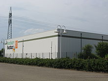
The largest company based in Lütgenrode is Beckers Bester ; there is also a gas station and an inn with a restaurant.
traffic
In the middle of Lütgenrode, the federal highway 446 runs from Duderstadt to Hardegsen , which crosses under the A7 at the eastern end of the village and has a driveway to it.
Lütgenrode is connected to local public transport with the bus routes operated by RBB Regionalbus GmbH . The next train station is in Nörten-Hardenberg.
Web links
Individual evidence
- ↑ Kirstin Casemir, Franziska Menzel, Uwe Ohainski, Jürgen Udolph (eds.): The place names of the district of Northeim, Lower Saxony book of place names, part V , Publishing House for Regional History, Bielefeld, 2005, pages 248–249, ISBN 3-89534-607-1
- ↑ Klaus Gehmlich: Wappenbuch for the Northeim district , paper plane, Clausthal-Zellerfeld, 2001
- ^ Heinrich Lücke: Lütgenrode . In: Southern Lower Saxony . No. 1 , 2012, ISSN 0931-1769 , p. 15 .
- ^ Heinrich Lücke: Lütgenrode . In: Southern Lower Saxony . No. 1 , 2012, ISSN 0931-1769 , p. 16 .
- ^ Heinrich Lücke: From the history of the village Parensen , Goltze, Göttingen, 1971, p. 62.
- ^ Weigand Heinrich: Heimat-Buch of the Northeim district in Hanover , 1924
- ^ Federal Statistical Office (ed.): Historical municipality directory for the Federal Republic of Germany. Name, border and key number changes for municipalities, counties and administrative districts from May 27, 1970 to December 31, 1982 . W. Kohlhammer GmbH, Stuttgart and Mainz 1983, ISBN 3-17-003263-1 , p. 214 .
- ↑ Erhard Kühlhorn: Historical-regional excursion map. Leaf Moringen am Solling . Ed .: Erhard Kühlhorn. Lax, Hildesheim 1976, ISBN 3-7848-3624-0 , p. 144 .
- ↑ Christian Kämmerer; Peter Ferdinand Lufen: Monuments in Lower Saxony - District Northeim Part 1 7.1 , 2002, pp. 196–197
- ↑ Ecclesiastical gazette for the Evangelical Lutheran Church of Hanover 1/2011, p. 57


