Northeimer Seenplatte
| Northeimer Seenplatte | ||
|---|---|---|

|
||
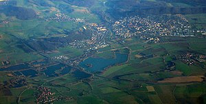
| Aerial view of the Northeimer Seenplatte u. a. with Hollenstedt (front left) Northeim (back right) | ||
| Geographical location | near Northeim , District Northeim , Lower Saxony ( Germany ) | |
| Location close to the shore | Northeim | |
| Data | ||
| Coordinates | 51 ° 44 '3 " N , 9 ° 57' 44" E | |
|
|
||
| Altitude above sea level | 110 m above sea level NHN | |
| surface | approx. 300 ha | |
|
particularities |
Baggersee Complex |
|
The Northeimer Seenplatte is a lake complex in the urban area of Northeim in the district of Northeim in southern Lower Saxony . Their bodies of water were created artificially through gravel mining and have become a popular local recreation area .
geography
location
The Northeimer Seenplatte lies in the Leinegraben in an approximately 2 km wide valley floor, predominantly orographically to the right along the Leine ; The Rhume flows into this tributary of the Aller directly west of the lake landscape . Places around the lake district are, in addition to the Northeim core city in the southeast, the Northeim districts of Höckelheim in the south, Hollenstedt in the west, Stöckheim in the northwest and Edesheim in the northeast. The lake district is located between about 108 (altitude in the north) and 111.1 m above sea level. NHN ( Great Lake in the South).
Natural allocation
The Northeimer Seenplatte belongs in the natural spatial main unit group Weser-Leine-Bergland (No. 37) and in the main unit Leine-Ilme-Senke ( Leinegraben ; 372) to the subunit Leineaue (372.3).
Soil structure
In the area of the Northeimer Seenplatte there are about 50 m of Pleistocene gravel under the soil layer . Due to the inflow of the Rhume , the Leinegraben lies in the pouring area of the Harz, so that the gravel is composed of greywacke , silica slate and brown coal quartz as well as sand and is found covered by floodplain sediments, loess soils and marl layers of clay.
history
In 1852 the Royal Hanover State Railways removed material for embankment embankment. By 1940 a water surface of about 6 hectares (ha) was created. Gravel mining was intensified from 1950 onwards. As a result, the water area grew to around 130 hectares by 1980 and is now more than 350 hectares. The quarry ponds that are no longer used are left to be recultivated. There are currently 12 lakes of various sizes. The lands are the property of a foundation and are administered by the Hanover Monastery Chamber.
Protected areas
In the north of the Northeimer Seenplatte, north-northwest of the federal motorway 7, there is the nature reserve (NSG) water bird reserve Northeimer Seenplatte ( CDDA -Nr. 166185; designated 1984; 80 hectares ) and parts of NSG Polder I in the Salzderhelden flood retention basin (CDDA-No. 165017; 1995; 5.23 km² ); Immediately to the north are parts of the Leiniederung Salzderhelden NSG (CDDA no. 389621; 2008; 4.97 km²). Also north-northwest of A 7 is the Bird Sanctuary -region Leinetal at Salzderhelden (VSG No. 4225-401;. 11.29 ha).
Birds
The Northeimer Seenplatte is centrally located between Solling and Harz in the transit area of water bird species that migrate from Northern Europe and Western Europe across Northern Central Europe to Southwest Europe and use the local nature and bird sanctuaries (→ Protected Areas section ) as resting places and foraging .
The bird species that attempted breeding here in the 1970s during extensive surveys include the great crested grebe , buzzard , kestrel , water rail , little ringed plover , turtle dove , kingfisher , sand martin , wagtail , meadow pipit , warbler , warbler and whinchat . Leisure activities in the immediate vicinity are disturbing to the birds. The birds therefore partially switch to the EU bird sanctuary for the Salzderhelden flood retention basin , which is upstream to the north.
In addition to birds, amphibians and dragonflies have settled on the water and bank areas of former mining sites. An observation platform is located at the attachment barrier near Hollenstedt on the L 572.
use
Technically
Gravel extraction on a given area of land takes place in open-cast mining . The implementation is carried out using conveyor systems and floating dredgers . The resulting pits fill up with groundwater. The material obtained is processed by sieving and tipping bridge trucks are filled via silo funnels for removal.
leisure
There are jetties for sailing boats and a boathouse on the Großer See . Bathing, diving and surfing are other possible water sports here. In addition, some lakes are used by anglers who bring stock of white fish for this purpose.
Traffic and walking
East of the lake area is the Northeim-Nord junction of the federal motorway 7 , which runs through the landscape in a north-east-south-west direction, with a connection there to the east-running federal road 3 (Northeim-Hollenstedt-Stöckheim). The north-south railway line runs through it ; from the latter branches off the state road 572 (Northeim – Hollenstedt – Stöckheim), which also leads through the landscape in Northeim . The Leine-Heide cycle path also runs through the lake district . There are hiking trails along some lakes.
literature
- Frank-Ulrich Schmidt: Water bird censuses and brood inventory surveys at the Northeimer Kiesseen (1969–1980) . In: Northeimer Jahrbuch 1980, pp. 6-75
- City of Northeim (Ed.): Northeimer Seenplatte . 19-page brochure, 2nd edition 1989.
See also
Web links
- Northeimer Seenplatte , on northeim.de
- Northeimer Seenplatte - economy, ecology and leisure time , on august-oppermann.de
Individual evidence
- ↑ a b c Map services of the Federal Agency for Nature Conservation ( information )
- ↑ reclamation on august-oppermann.de
- ↑ "Northeimer Seenplatte water bird reserve" nature reserve

