
Locking nut
| Locking nut | ||
 The free beer source is the best known source of the Sperrlutter |
||
| Data | ||
| Water code | DE : 488262 | |
| location | Resin ; Districts of Goslar and Göttingen ; Lower Saxony ( Germany ) | |
| River system | Weser | |
| Drain over | Or → Rhume → Leine → Aller → Weser → North Sea | |
| source | in the Harz on the Jordanshöhe near Sankt Andreasberg 51 ° 43 ′ 24 ″ N , 10 ° 31 ′ 13 ″ E |
|
| Source height | approx. 707 m above sea level NHN | |
| muzzle | in Sankt Andreasberg in the Oder Coordinates: 51 ° 38 '36 " N , 10 ° 29' 26" E 51 ° 38 '36 " N , 10 ° 29' 26" E |
|
| Mouth height | 315 m above sea level NHN | |
| Height difference | approx. 392 m | |
| Bottom slope | approx. 36 ‰ | |
| length | approx. 11 km | |
| Catchment area | 28.1 km² | |
| Left tributaries | Laundry ground , warm hole, Breitenbeek | |
| Right tributaries | Brook from the Great Vallunga | |
| Small towns | Braunlage , Bad Lauterberg | |
The Sperrlutter in the Upper Harz is an approximately 11 km long tributary of the Oder between Sankt Andreasberg and Bad Lauterberg in the Lower Saxony districts of Goslar and Göttingen .
course
The Sperrlutter rises in the Harz near Sankt Andreasberg , a district of Braunlage . Their source is at an altitude of about 707 m above sea level. NHN on the western flank of the Jordanshöhe (approx. 723 m ) - a little northeast above the Glückaufklippen , located southeast below the summit ( 729.1 m ) . Below these cliffs, it is fed by the water from the free beer spring.
The Sperrlutter, which initially passes to the west of Sankt Andreasberg and then to the west of the Galgenberg ( 594.3 m ), flows south through the village of Silberhütte , where the Waschegrund flows from the east , and through the hamlet of Sperrluttertal . It is then fed by the Breitenbeek, which comes from the northeast, as the longest Sperrlutter tributary.
Then the Sperrlutter reaches the Bad Lauterberg locality Odertal , where it flows a little below the compensation basin of the Oder dam at a height of about 315 m into the Rhume- tributary Oder flowing there from the east .
photos
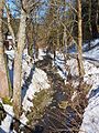
The Sperrlutter in Silberhütte

The bottom of the laundry flows into the lock nut

The Breitenbeek flows into the Sperrlutter
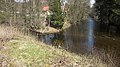
Confluence of the Sperrlutter into the Oder near Bad Lauterberg


swell
- Topographic map 1: 25000, No. 4229 Braunlage
- Topographic map 1: 25000, no. 4329 Zorge
- Topographic map 1: 25000, No. 4328 Bad Lauterberg in the Harz Mountains
- Area directory for the Hydrographic Map Lower Saxony (Weser) → individual records
Individual evidence
- ↑ a b Topographic map with Sperrlutter history ( memento of the original from March 4, 2016 in the Internet Archive ) Info: The archive link was inserted automatically and has not yet been checked. Please check the original and archive link according to the instructions and then remove this notice. (DTK 25; see large enlargement of the map), on natur-erleben.niedersachsen.de
- ↑ List of areas for the Hydrographic Map of Lower Saxony (Weser), water network and coastal waters of Lower Saxony, at Umwelt.niedersachsen.de (PDF; 599 kB)