
Dome (resin)
| Knoll | ||
|---|---|---|
| height | 729.1 m above sea level NHN | |
| location | near Sankt Andreasberg , Goslar district , Lower Saxony ( Germany ) | |
| Mountains | Harz ( Upper Harz ) | |
| Dominance | 1.5 km → Rehberg | |
| Notch height | 22 m ↓ Haus Sonnenberg | |
| Coordinates | 51 ° 43 '36 " N , 10 ° 30' 31" E | |
|
||

The summit in the Harz Mountains is 729.1 m above sea level. NHN high mountain near Sankt Andreasberg in the Lower Saxony district of Goslar .
geography
location
The summit rises in the Upper Harz in the Harz Nature Park . Its summit is just under 2 km north-northwest of the center of Sankt Andreasberg and joins the Jordanshöhe to the west . The Glückaufklippen ( ⊙ ) are located on the common southern flank of both mountains and the source of the Sperrlutter on the western flank of the Jordanshöhe . To the southwest the landscape slopes down through the Dreibrode valley into the Sieber valley.
Parts of the Harz landscape protection area (district of Goslar) ( CDDA no. 321402; 2001 designated; 389.75 km²) are located on the hilltop .
Natural allocation
The summit is located in the natural spatial main unit group Harz (No. 38), in the main unit Middle Harz ( Upper Harz ; 380) and in the subunit Southern Central Harz ( Southern Upper Harz ; 380.8) on the border of the natural areas Andreasberger Plateau (380.83) in the east and Sieberbergland ( 380.82) in the west.
gallery

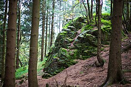
Glückaufklippe from the southeast
Glückaufklippe from the east

View from the top to the south of Sankt Andreasberg


