Billy Mitchell (volcano)
| Billy Mitchell | ||
|---|---|---|
|
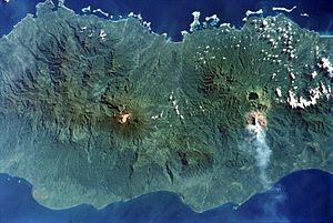
On the right the dark crater lake of the Billy Mitchell volcano, underneath the ash cloud of the Bagana. |
||
| height | 1544 m | |
| location | Bougainville | |
| Mountains | Emperor Range | |
| Coordinates | 6 ° 5 '30 " S , 155 ° 13' 30" O | |
|
|
||
| Type | Pyroclastic shield volcano | |
| Last eruption | 1580 ± 20 years | |
Billy Mitchell is a pyroclastic shield volcano in the center of the island of Bougainville , immediately northeast of the 1730 m high Bagana , one of the most active volcanoes in Papua New Guinea . On the 1544 m high summit of Billy Mitchell is a caldera filled with a crater lake . The Billy Mitchell Lake extends over an area of 3 km² and has a depth of 90 m. A drain on the northern edge of the caldera leads to the Tekan River. The volcano's last two major eruptions occurred around 1030 and 1580. This eruption, along with other volcanic events and lower sun activity, is the cause of the Little Ice Age , a period of relatively cool climates from the beginning of the 15th century into the 19th century.
The volcano was named after the US General William "Billy" Mitchell , founder of the United States Army Air Service .
Web links
- Billy Mitchell (Vulkan) in the Global Volcanism Program of the Smithsonian Institution (English)
Individual evidence
- ↑ George Steinmetz, Billy-Mitchell-See, photo in the GEO calendar "Water World" ( page no longer available , search in web archives ) Info: The link was automatically marked as defective. Please check the link according to the instructions and then remove this notice.

