
Galgenberg (Sankt Andreasberg)
| Gallows Mountain | ||
|---|---|---|
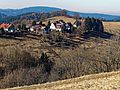
.jpg) View from the Glockenberg west-northwest to the Galgenberg with Sankt Andreasberg to the east of the summit region |
||
| height | 594.3 m above sea level NHN | |
| location | near Sankt Andreasberg ; District of Goslar , Lower Saxony ( Germany ) | |
| Mountains | resin | |
| Coordinates | 51 ° 42 ′ 33 " N , 10 ° 30 ′ 11" E | |
|
||
| particularities |
Grünhirscher tunnel , Sieber tunnel , shaft five books Moses , shaft Felicitas |
|

The Galgenberg near Sankt Andreasberg in the district of Goslar in Lower Saxony is 594.3 m above sea level. NHN high mountain in the Harz low mountain range .
geography
location
The Galgenberg is located in the Upper Harz in the Harz Nature Park . It rises 1.1 km west-southwest from the town hall of the Braunlager district of Sankt Andreasberg. The Schwalbenherd district is located on the mountain, which runs in an east-west direction . The mountain is bordered by the Sperrlutter valley in the north, west and south and by the Grüner Hirsch valley in the southeast.
Neighbors are the Kuppe ( 729.1 m ; north-northeast), the Jordanshöhe (approx. 723 m ; northeast), the Beerberg ( 658.1 m ; east), the Glockenberg (approx. 627 m ; east-southeast), the Knieberg ( 556 m ; south-southeast), the Koboltstaler Köpfe (approx. 673 m ; south-west) and the Sieberberg (approx. 600 m ; west).
Parts of the Harz landscape protection area (district of Goslar) ( CDDA no. 321402; 2001 designated; 389.75 km²) are located on the Galgenberg .
Natural allocation
The Galgenberg belongs in the natural spatial main unit group Harz (No. 38), in the main unit Middle Harz ( Upper Harz ; 380) and in the subunit Southern Central Harz ( Southern Upper Harz ; 380.8) to the natural area Oderbergland (380.81). The landscape leads west through the Sperrlutter valley into the Sieberbergland natural area (380.82).

View from Glockenberg to Schwalbenherd
View from the northeast to the Galgenberg with swallow hearth

Dennert-Tanne on the Armen-Sünder-Gasse on the way to the Galgenberg


.jpg)
history
With the town charter granted in 1537, the mining town of Sankt Andreasberg received its own jurisdiction. In 1663 Christian Ludwig , Duke of Braunschweig-Lüneburg , had a gallows set up on the Galgenberg. The condemned were led over the poor sinners alley and the way Auf der Höhe to the gallows. On the way, they should have the opportunity to sit on a stone and ponder their sins while looking over the mountain town.
Mining and Upper Harz Water Shelf
The Sieberstollen runs through the north flank of the Galgenberg and the Grünhirscher gallery runs through the southeast flank , both of which belong to the Upper Harz water shelf . On the north side there is the five books of Moses shaft and the Felicitas shaft .
