
Drammetal motorway triangle
| Drammetal motorway triangle | |
|---|---|
|
|
|
| map | |
 |
|
| location | |
| Country: | Germany |
| State : | Lower Saxony |
| Coordinates: | 51 ° 27 '11 " N , 9 ° 51' 52" E |
| Height: | 210 m above sea level NN |
| Basic data | |
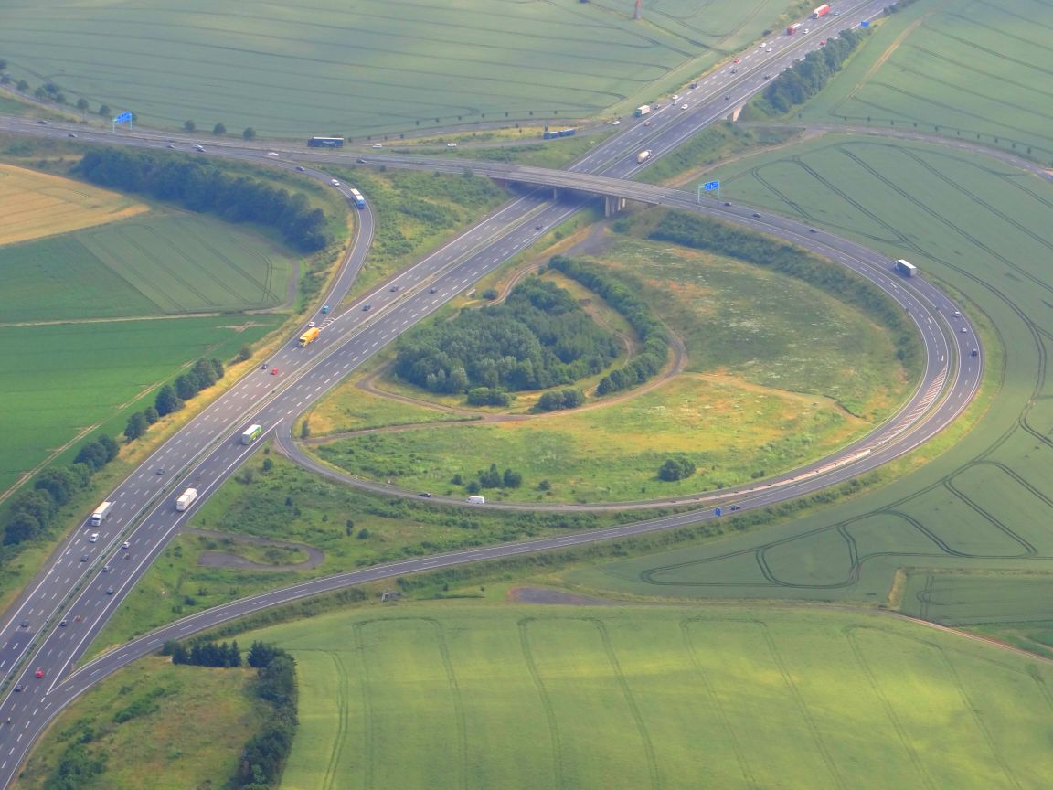
| Design type: | Right-hand trumpet |
| Bridges: | 1 (motorway) / 2 (other) |
| Construction year: | 2003 |
The Drammetal motorway triangle (abbreviation: AD Drammetal ; short form: Drammetal triangle ) is a motorway triangle in Lower Saxony in the south of the Hanover metropolitan region . It connects the federal highway 38 ( Südharzautobahn ) with the federal highway 7 ( Flensburg - Hanover - Kassel - Füssen ; Europastraße 45 ).
geography
The triangle lies in the municipality of Rosdorf in the district of Göttingen , between the districts of Dramfeld and Volkerode . The surrounding communities are Friedland and Jühnde . It is located about 10 km south of Göttingen , about 30 km northeast of Kassel and about 145 km west of Halle (Saale) . A few kilometers to the south lies the border triangle between Lower Saxony , Thuringia and Hesse .
The triangle is on the edge of the Münden Nature Park .
The Drammetal motorway triangle has junction number 74 on the A 7 and number 1 on the A 38.
Design and state of development
Although the triangle emerged from the former Friedland junction until 2003 , it is almost completely new. The design as a "right-hand trumpet" was adopted, but by widening the curves it was made about twice as large. At the same time, the previous federal highway 524 was expanded to the A 38 and the A 7 was widened to six lanes. Since the B 524 was laid out as part of the connection from Eschwege to the north at the time of the division of Germany , the A 38 and A 7 (from the south) meet at an acute angle of about 60 °.
The A 7 has six lanes, the A 38 four lanes. Except for the connecting ramp from the north to the A 38 to the east (two lanes), all ramps are single-lane.
Naming
It was named after the valley of the Dramme river , which is crossed by both motorways south of the triangle. This was preceded by a fierce dispute between the university town in the north, which advocated "Dreieck Göttingen Süd", and Friedland, who fought over the name of the traffic junction in the area of the municipality of Rosdorf, according to the previous name for "Dreieck Friedland". On the A 7, signs indicated the old name for several years until mid- 2008 .
Accident blackspot
The right-hand bend on the transition from the A 38 in the direction of Kassel has become a hotspot for accidents. From January to September 2009 the guardrail was damaged 44 times. This was then replaced by a concrete wall, which on the one hand should serve as a “psychological speed brake” and on the other hand withstand the impact of a car.
Traffic volume
The triangle is used by around 83,000 vehicles every day.
| From | To | Average daily traffic volume |
Share of heavy goods traffic |
|---|---|---|---|
| AS Rosdorf (A 7) | AD Drammetal | 66,300 | 16.2% |
| AD Drammetal | AS Hann. Münden - Hedemünden (A 7) | 69,600 | 20.2% |
| AD Drammetal | AS Friedland (A 38) | 29,700 | 21.1% |
Individual evidence
- ^ AD Drammetal. (No longer available online.) Autobahn intersections & Autobahn triangles in Germany, 2011, formerly in the original ; Retrieved April 28, 2013 . ( Page no longer available , search in web archives ) Info: The link was automatically marked as defective. Please check the link according to the instructions and then remove this notice.
- ↑ Concrete wall is supposed to slow down speeders. www.goettinger-tageblatt.de, July 8, 2009, accessed on November 6, 2009 .
- ↑ Manual traffic census BAB 2015. (PDF) BASt Statistics, 2015, accessed on August 29, 2017 .
Web links
AK Rendsburg | AD Bordesholm | AD Hamburg-Northwest | AD Hamburg-Südwest | Mesh cross | Horster triangle | AD Walsrode | AD Hanover-North | AK Hannover / Kirchhorst | AK Hannover-Ost | AD Hanover-South | AD Salzgitter | AD Drammetal | AK Kassel-Mitte | AD Kassel-Süd | Kirchheim triangle | Hattenbacher triangle | AD Fulda | AK Schweinfurt / Werneck | AK Biebelried | AK Feuchtwangen / Crailsheim | AK Ulm / Elchingen | AK Memmingen | AD Allgäu
AD Drammetal | AS major changes | AD Südharz | AD Halle-Süd | AK Rippachtal | AS Leipzig-South | AD Parthenaue