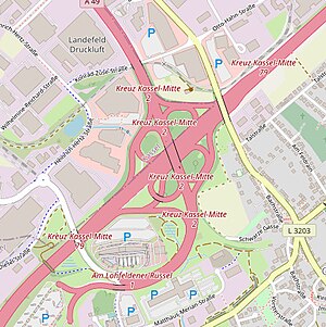
Kassel-Mitte motorway junction
| Kassel-Mitte motorway junction | |
|---|---|
|
|
|
| map | |
| location | |
| Country: | Germany |
| State : | Hesse |
| Coordinates: | 51 ° 16 '33 " N , 9 ° 31' 44" E |
| Height: | 170 m above sea level NN |
| Basic data | |
| Design type: | Adapted shamrock |
| Bridges: | 1 (motorway) / 4 (other) |
| Last modification: | 2007 |
The motorway junction Kassel-Mitte (abbreviation: AK Kassel-Mitte ; short form: Kreuz Kassel-Mitte ) is a motorway junction near Kassel in Hesse . This is where the federal motorway 7 ( Flensburg - Hanover - Füssen ) ( Europastraße 45 ) and the federal motorway 49 (Kassel - Schwalmstadt ) intersect .
geography
The cross lies in the area of the city of Kassel and the municipality of Lohfelden . The closest districts are Crumbach , Waldau , Erlenfeld and Forstfeld . It is located about 5 km southeast of Kassel's city center, about 40 km southwest of Göttingen and about 65 km northwest of Eisenach .
Not far from the cross is the Fulda , which the A 49 crosses with a bridge structure.
It is located on the western edge of the Frau-Holle-Land Geo-Nature Park (Werratal.Meißner.Kaufunger Wald) .
The Kassel-Mitte motorway junction is number 79 on the A 7 and number 2 on the A 49.
Development condition and design
The A 7 is expanded to six lanes in this area, the A 49 has four lanes. All transitions are single-lane.
The crossing structure was built in the form of an adapted clover leaf .
Traffic volume
It is a busy road junction in Hesse with around 102,000 vehicles per day in 2015.
| From | To | Average daily traffic volume |
Share of heavy goods traffic |
||||
|---|---|---|---|---|---|---|---|
| 2005 | 2010 | 2015 | 2005 | 2010 | 2015 | ||
| AS Dreieck Kassel-Ost (A 7) | AK Kassel-Mitte | 79,000 | 80,600 | 89,100 | 17.4% | 18.2% | 18.8% |
| AK Kassel-Mitte | AD Kassel-Süd (A 7) | 61,800 | 62,800 | 77,900 | 16.4% | 21.0% | 18.0% |
| End of motorway (K 9) | AK Kassel-Mitte | no data | 9,000 | 7,700 | no data | 14.0% | 20.2% |
| AK Kassel-Mitte | AS Kassel industrial park (A 49) | 32,900 | 27,400 | 29,300 | 13.9% | 14.3% | 16.0% |
Individual evidence
- ^ AK Kassel-Mitte. Motorway junctions and triangles in Germany, 2011, accessed on December 3, 2012 .
- ↑ Manual road traffic census 2005. (PDF) Results on federal motorways. BASt Statistics, 2005, accessed on October 17, 2017 .
- ↑ Manual road traffic census 2010. (PDF) Results on federal motorways. BASt Statistics, 2010, accessed on October 17, 2017 .
- ↑ Manual road traffic census 2015. (PDF) Results on federal motorways. BASt Statistics, 2015, accessed on October 17, 2017 .
