Waldau (Kassel)
|
Waldau district of Kassel |
||
|---|---|---|
| Coordinates | 51 ° 17 ′ 19 ″ N , 9 ° 31 ′ 4 ″ E | |
| height | 145 m above sea level NHN | |
| surface | 6.48 km² (6/23) | |
| Residents | 6393 (Dec. 31, 2019) (17/23) | |
| Population density | 987 inhabitants / km² (18/23) | |
| Proportion of foreigners | 21.1% (Dec. 31, 2019) (9/23) | |
| Incorporation | Jun 1, 1936 | |
| Post Code | 34123 | |
| prefix | 0561 | |
| Website | District information Waldau | |
| politics | ||
| Mayor | Joachim Bonn ( SPD ) | |
| Allocation of seats (local advisory board) | ||
|
||
| Source: Kassel Statistical Atlas | ||
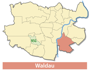
Waldau is one of 23 districts of Kassel in Hesse ( Germany ). It is located in the south-eastern part of the city to the right of the Fulda .
history
The first written mention of Waldau was in 1293. In 1377 a parish church was built in Waldau , which fell under the patronage of the Landgraves of Kassel . In the 15th century was an existing Kemenate to Wasserburg Waldau rebuilt. The first documentary evidence is available in 1484. Only two round defense towers with a piece of wall remain from the castle . They form the outer wall for a half-timbered house . In the Topographia Hassiae (1655) it says: “Hart in front of Cassel / in front of the Newstatt / there is a very large, wide flat meadow / called the forest / because it was previously a forest / but / because of the earth's vesting / damaging it / and something in it has been played / disturbed. Vmb this flat, pretty villages / including one called the Waldau / where you can still see / see buildings from an old robbery castle / with a considerable moat. "
From 1798 to 1815, the Waldau Forestry School was located in Waldau . It was a training institute for foresters set up by the Hessian Landgraviate .
In 1936 Waldau was incorporated into Kassel.
From 1924 to 1970, the Kassel airfield Kassel-Waldau was set up near Waldau on the site south of the A 49 and west of Marie-Curie-Strasse . From 1970 to 2013 the airfield Kassel-Calden in the municipality of Calden was in operation; and from this emerged the neighboring Kassel-Calden airport .
District development and cityscape
The residential town of Waldau , which emerged in the 1960s, is characterized by its functional construction in flat rows and dots . A small district center near the core of the old village along Kasseler Strasse dates from the same construction period. Originally, large-scale gardening and arable farming were carried out on the (as yet undeveloped) areas, which was productive on the soils of the Fulda lowlands to the east.
politics
The local councils in Kassel have been directly elected since 1981 . After the local elections in 2006, Joachim Bonn was elected mayor from the ranks of the local council.
traffic
After the junction from the A 7 at Lohfelder Rüssel , the A 49 crosses Waldau and crosses the B 83 at the Kassel-Waldau junction , which runs through the district from north to south.
economy
Together with the neighboring Lohfelden , the industrial park Kassel-Waldau was developed in 1971 and expanded to include Waldau-Ost for the relocation of medium-sized companies, the municipal slaughterhouse and chain stores from the 1990s . The area now covers around 230 hectares and is home to around 500 companies with around 10,000 employees. The character of the area has meanwhile developed from the focus on production with the associated administrative units of companies to the intersection of service companies with public traffic.
With the Lohfeldener Rüssel , the necessary development possibilities for the expansion as a logistics location and the establishment of the freight transport center GVZ Kassel have been created in recent years . Originally, this area was used as a small airfield.
societies
The following associations or communities are based in Waldau:
- Friends of the Waldauer Duck Kirmes eV
- Waldau volunteer fire department
- Gymnastics and Sports Club e. V. Kassel-Waldau (Tuspo Waldau)
- Waldauer country women
Personalities
- Elise von Hohenhausen (1789–1857) , poet, storyteller, publicist, translator and salonnière
- August von Ende (1815–1889), Prussian civil servant, chief president of the province of Hessen-Nassau
- Friedrich Geb (1847–1927), architect
- Hilde Weber (1913–1994), German-Brazilian painter, draftsman, illustrator and ceramist
- Stephan Zagrodnik (1916–1990), politician, member of the People's Chamber
Web links
- Waldau, municipality of Kassel. Historical local dictionary for Hessen. In: Landesgeschichtliches Informationssystem Hessen (LAGIS).
Individual evidence
- ^ Burg Waldau, City of Kassel. Historical local lexicon for Hesse (as of November 4, 2010). In: Landesgeschichtliches Informationssystem Hessen (LAGIS). Hessian State Office for Historical Cultural Studies (HLGL), accessed on July 11, 2012 .
- ↑ Martin Zeiller in Topographia Hassiae , Volume 7 of Topographia Germaniae , 2nd edition: Frankfurt am Main: Matthaeus Merians Erben 1655, pp. 35–36, full text at Wikisource
- ↑ Waldau's story
- ^ Waldau district history , on kassel.de
