Bordesholm motorway triangle
| Bordesholm motorway triangle | |
|---|---|
|
|
|
| map | |
| location | |
| Country: | Germany |
| State : | Schleswig-Holstein |
| Coordinates: | 54 ° 10 '18 " N , 9 ° 57' 29" E |
| Height: | 10 m above sea level NN |
| Basic data | |
| Design type: | Motorway fork |
| Bridges: | 1 (motorway) / 3 (other) |
| Construction year: | 1971 |
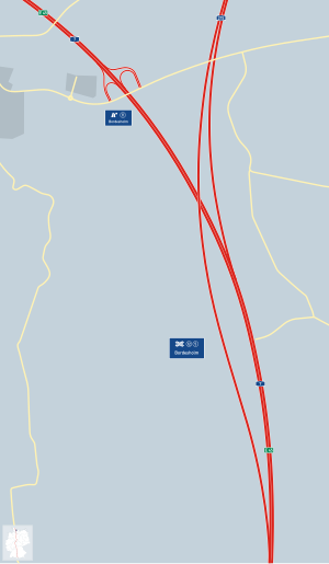
The Bordesholm motorway triangle (abbreviation: AD Bordesholm ; short form: Bordesholm triangle ) is a motorway triangle near Neumünster in Schleswig-Holstein . It connects the federal motorway 7 ( Flensburg - Füssen ; E 45 ) with the federal motorway 215 ( Kiel - Bordesholm ).
geography
The motorway triangle is in the area of the local communities Dätgen , Hoffeld , Loop and Schönbek in the Rendsburg-Eckernförde district . It is located about 20 km southwest of Kiel, about 70 km north of Hamburg and about 75 km southeast of Flensburg. Furthermore, the triangle lies in the middle of the Westensee Nature Park .
The Bordesholm motorway triangle has junction number 12 on the A 7 and number 5 on the A 215.
Design and state of development
The A 7 has six lanes south of the triangle. To the north of it, both motorways have four lanes. The connecting ramps have two lanes as they mark the end of the A 215. There are only the relations Kiel - Hamburg and vice versa, the lack of ramps from the A 215 in direction Flensburg and vice versa, among others, the A 210 taken (from the cross Kiel-West to Rendsburger Kreuz on the A7).
The triangle is designed as a fork . The main bridge structure leads the A 215 over the A 7.
As part of the PPP project between the federal government and Via Solutions Nord , the A 7 between the Bordesholm triangle and the Hamburg-Nordwest triangle was expanded to three lanes in each direction. Construction work on the 1st construction section between the Bordesholm motorway triangle and the Neumünster-Mitte junction began in November 2014. The expanded section was opened to traffic on December 16, 2016.
Traffic volume
The triangle is traveled by an average of around 67,000 vehicles every day.
| From | To | Average daily traffic volume |
Share of heavy goods traffic |
||||
|---|---|---|---|---|---|---|---|
| 2005 | 2010 | 2015 | 2005 | 2010 | 2015 | ||
| AS Bordesholm (A 7) | AD Bordesholm | 34,800 | 34,400 | 39,400 | 18.7% | 16.6% | 16.9% |
| AD Bordesholm | AS Neumünster-Nord (A 7) | 62,600 | 64,100 | 65,800 | 12.6% | 12.3% | 12.2% |
| AS Blumenthal (A 215) | AD Bordesholm | 27,000 | 26,800 | 28,300 | 6.0% | 6.1% | 6.9% |
Junction points and driving relationships
|
↓↓ ↑↑ |
↓↓ ↑↑ |
|

|
||
|
↓↓↓ ↑↑↑ |
Trivia
In the direction of Kiel, the A 215 at the Bordesholm triangle begins at km 2.1. In the direction of Hamburg, the kilometrage ends at the junction with the A 7 at km 0.0. This is due to the fact that there are approx. 2 km between the merging of the A 215 onto the A 7 in the direction of Hamburg and the junction of the A 215 in the direction of Kiel. The fixed point of the kilometering is the end of the Kiel-Hamburg ramp.
See also
Individual evidence
- ↑ Construction site A7: Major project causes a risk of traffic jams until 2018. Radio Schleswig-Holstein , January 19, 2015, accessed on February 11, 2016 .
- ↑ Questions and answers on the expansion of the A7 federal motorway. (No longer available online.) Via Solutions Nord, 2015, archived from the original on February 11, 2016 ; accessed on February 11, 2016 .
- ↑ Manual road traffic census 2005. (PDF) Results on federal motorways. BASt Statistics, 2005, accessed on March 15, 2018 .
- ↑ Manual road traffic census 2010. (PDF) Results on federal motorways. BASt Statistics, 2010, accessed on March 15, 2018 .
- ↑ Manual road traffic census 2015. (PDF) Results on federal motorways. BASt Statistics, 2015, accessed on March 15, 2018 .
