Feldberger Lakes
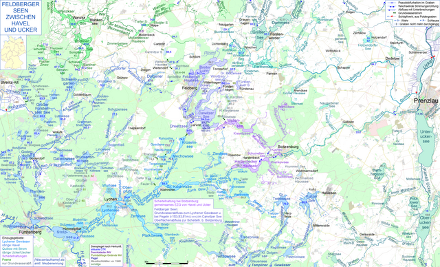
At Feldberg in the Feldberger Seenlandschaft community named after them in the southeast of Mecklenburg-Western Pomerania, there is a group of lakes that are very close to one another with common drainage routes to both the Havel and the Ucker .
Drainage routes
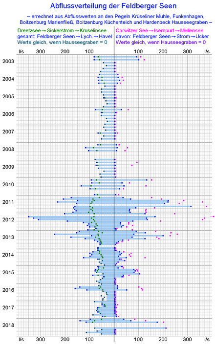
The groundwater runoff takes place from Dreetzsee to Krüselinsee , whose water flows through the Mechowbach and Lychener waters to the Havel. From the Carwitzer See there is the Isernpurt (Iron Gate), which was laid out as an open canal between 1575 and 1578 and piped in the 20th century, to the Mellensee . It pumps at water levels from 83.81 m above sea level (Carwitz gauge 150 cm at a PNP of 82.307 m above sea level, long-term mean water 154 cm). The Mellensee drains through the Marienfließ to oneVertex posture near Boitzenburg , consisting of the Boitzenburger Küchenteich , the Schumellensee , the Hardenbeck Haussee and the large cross-sectional canal connecting them. This always releases water from the Boitzenburg kitchen pond into the river in the direction of the Ucker , which is why Isernpurt and Marienfließ are also considered river sections of the river. The other process of vertex posture goes from the Hardenbeck Haussee through the Hausseebruchgraben to the Lychener waters. It is already shown in the Schmettauschen map series of the 18th century and at times has a larger drainage than the water released from the kitchen pond into the stream.
Grouping of lakes
The Feldberger Lakes are divided into an upper and a lower group. The upper group consists of the Breite Luzin , the Feldberger Haussee and the Schmalen Luzin . They are connected by three short channels and, according to most old and new data sets, have approximately the same water level. Their water comes from the Schmales Luzin through the Bäk into the Carwitzer See.
The Carwitzer See is connected to the Dreetzsee by a canal that can be used with motor boats when the water level is high and only paddle boats when the water level is low. According to information from local residents, this canal has no noticeable current, according to the hydrological framework conditions changing flow directions. In very humid weather, the surface runoff through the Isernpurt can also cause water to move from the Dreetzsee to the Carwitzer See. Otherwise, the groundwater runoff from the Dreetzsee is greater and must result in a movement of water from the Carwitzer See there.
The groundwater runoff causes the water level of the two lower lakes to drop further when it has fallen below the bottom of the Isernpurt. As a result, the difference in altitude between the upper and lower lake group and thus the slope of the Bäk increases in dry weather.
The Carwitzer See has a long arm that extends northeast, the Zansen. At the end of this, the floot of the Wootzensee flows out , the water level of which is only slightly higher (according to most representations, the same height).
Lakes outside the core group
But isolated in the middle
In the middle between Schmalem Luzin and Zansen lies the Scharteisensee, which is only connected to the rest of the world by groundwater connections.
Connection through surface water and culverts
The Wootzensee receives an inflow through a ditch from the Großer Plötzensee, which is almost ten meters higher, and through a predominantly piped connection from the Fürstenauer See, which is 15 m higher .
The wide Luzin has two tributaries in its northernmost bay. The western one comes from the Lichtenberger Buchen forest area and is classified as the source stream of the river. The eastern one comes from the Lichtenberg firs and drains two of the soils north of this forest area in the field marrow of the village of Lichtenberg .
Inland catchment areas
To the east of the Carwitzer See are the two carp lakes and the Bible lake, which are connected by a ditch. The Big Carp Lake can overflow into a leading Floot to ditch after massive rainfall, but he has not beaten a discharge path. The paths of the groundwater runoff are uncertain.
At the Bibelsee (86.4 m above sea level), groundwater runoff to the Mellensee, which is almost ten meters below, is likely.
The inland catchment areas of the Sprockfitz , Weitendorfer Haussee and Cantnitzer See are located northwest of the Feldberger Haussee . The water level of the Sprockfitz varies by five to seven meters. The groundwater levels there are continuously monitored by probes north and south of the Weitendorfer Haussee. Changing slopes were observed, from which it is concluded that the directions of the groundwater flows also change, sometimes seeping towards Feldberger Haussee and sometimes towards Möllenbeck Haussee . That flows through the Warbender Mühlenbach- Nonnenbach to the Tollensesee and thus to the Peene .

Readable display sizes: 20% (1271 x 770 px) - 25% (1674 x 1027) - 33% (2542 x 1540 px)
Web links
Individual evidence
- ↑ According to the dataset of the MV Seenkataster, the water level of the Dreetzsee is 2 decimeters above that of the Carwitzer See, but this was described as an error by the responsible employee of the Environment Ministry.
Sources of information
- Documentation of the condition and development of the most important lakes in Germany - Part 2 Mecklenburg-Western Pomerania (PDF)
- StALU Mecklenburg Lake District: Management Plan Schmaler Luzin with Zansen and Carwitzer See (PDF)
- StALU Mecklenburg Lake District:
- Course of the water levels of the Carwitzer See
- Discharge measurements at the Krüseliner Mühle gauge (Mechowbach)
- LfU Brandenburg: discharge measurements at the gauges
- Funkenhagen (Isernpurt (current))
- Boitzenburg Marienfließ (stream)
- Boitzenburg Küchteich (electricity)
- Hardenbeck (Hausseebruchgraben)
Coordinates: 53 ° 17 ′ 57 ″ N , 13 ° 26 ′ 18 ″ E


