
Nonnenbach (Tollense)

The Nonnenbach , also known as the nun , is a river in Mecklenburg-Western Pomerania. The upper course was formerly regarded as a tributary of the linden tree , to which a tributary splits off at a bifurcation . The lower course is one of the fastest flowing waters in Mecklenburg. The flow path from the source at Vorheide the mouth of the Peene in Peenestrom is 185 km one of the longest in the river system of the Peene, more than 40 km longer than that of any of the Peene -mentioned sources.
The Nonnenbach probably got its name after the Cistercian nuns of the Wanzka Monastery on Wanzkaer See, which was founded in 1290 and whose facilities included extensive lands in the vicinity of the lake and brook.
geology
The Nonnenbach flows through the Wanzkaer See in the area of the main terminal moraine of the Pomeranian stage of the Vistula glaciation . About 15,000 years ago, when the ice sheet was melting, the glacier dammed its meltwater in the basin of what is now Lake Wanzka. The pent-up water broke through the lowest point of the moraine to the west and flowed down to the Tollensee basin. Because of the steep slope of the new river, the receding erosion created the river bed, which was cut deep into the landscape.
Recent aquatic history
The big break in the southwest continuation of the Camminer See is flat. In the late 19th century, the water of the Warbender Mühlbachse flowed mainly into the Camminer See and only a small trickle branched off from it to the west in the direction of Wanzkaer See . The river bifurcation was 62 m above sea level, the level of Lake Camminer only 61.4 m. The Warbender Mühlenbach flowed through the Camminer See to the linden tree .
Today the cartographic boundaries of the catchment areas and the water stations document an opposite flow direction of the stream through the Great Break. According to this, the Camminer See is now drained in two directions, so it has become a pseudobifurcation . The old bifurcation in the south of the quarry has become an estuary, and the Werbender Mühlbach is now the main tributary of the Wanzkaer See and thus the upper reaches of the Nonnenbach.
The cause is the lowering of the water level in Lake Wanzka, partly due to natural processes, partly caused by humans.
River course

 | |||
Nonnenbach: |
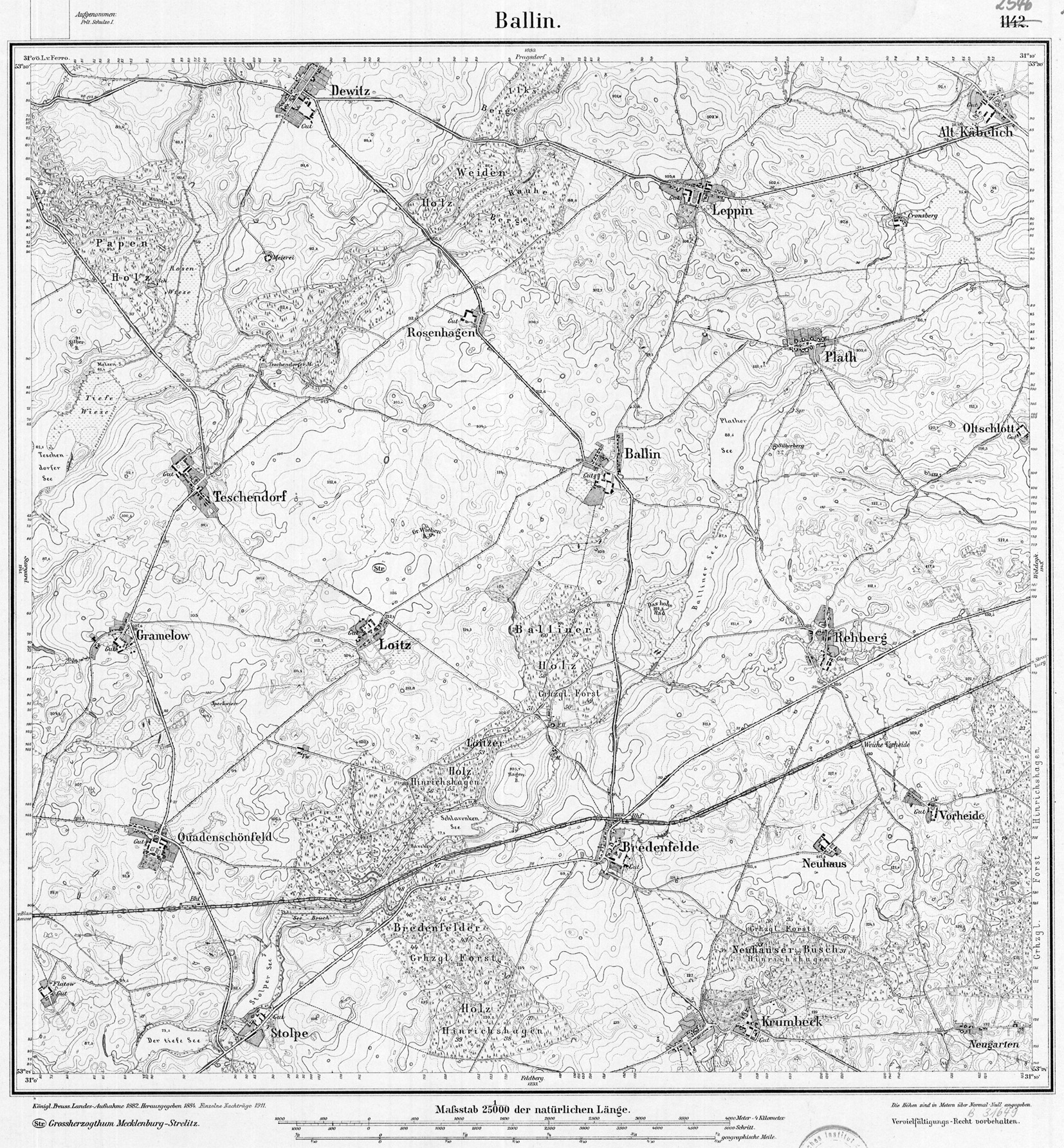
The upper course is created by merging the smallest spring streams east of Vorheide in the Hinrichshagen nature reserve in the municipal area of the city of Woldegk . The course of the water around Rehberg is underground. Then, below the Balliner See , the valley of the Werbender Mühlenbach is reached. The advertiser Mühlenbach flows through several lakes, the Schlavenkensee , the Stolper See , the Tiefen See and the Möllenbeck Haussee .
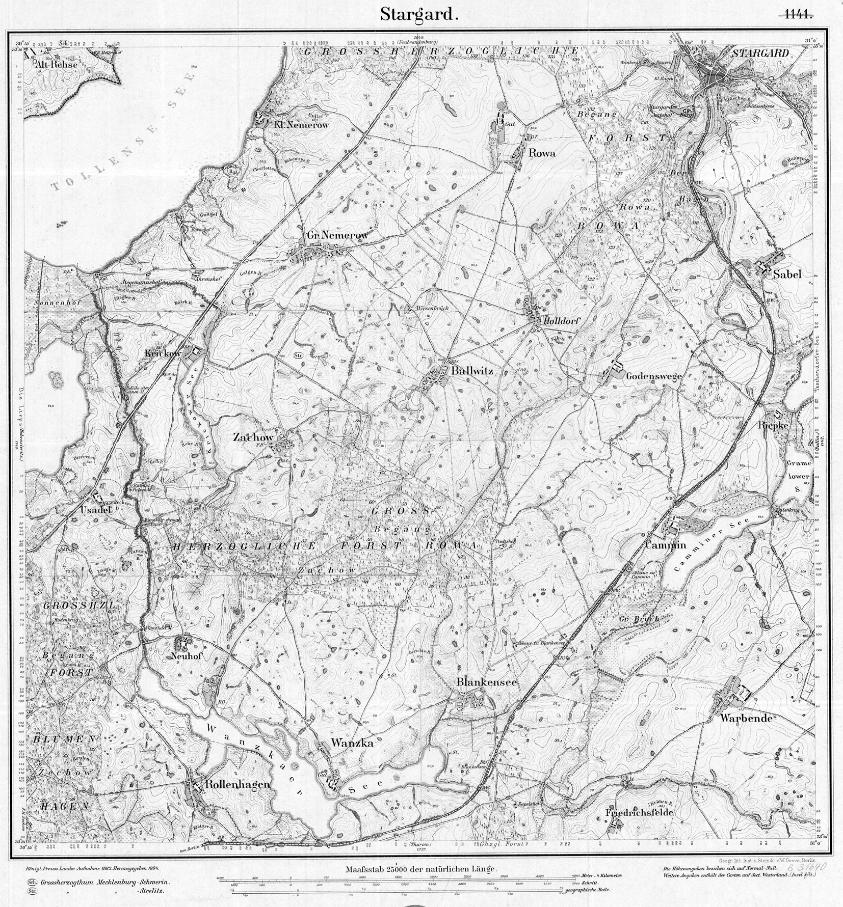
At Blankensee, the water bends north and reaches the junction that was a bifurcation from the 18th century at the latest until the early 20th century. In the Schmettau map from 1788 there are no directional arrows at the waters between Camminschem and Wansker See. Before the narrow point where the Wanzkaer See is crossed by the road from Wanzka to Rödlin , a 13.4 km long body of water flows from the south (GKZ = 966426), which flows through several lakes, lastly the Rödliner See . Coming from the Wanzkaer See, the Nonnenbach then flows into the Tollensesee at Nonnenhof . This stretch of water is only six kilometers long. Over this short distance, it has a gradient of around 41 meters. It is one of the fastest flowing rivers in northern Germany. In the upper part of this section it flows in a deeply washed-out narrow valley-like bed. The confluence with the Tollensesee is 410 m south of km 78.3 of the Tollense river path, which hydrologically includes the Ziemenbach , which flows a little further west into the Tollensesee .
environment

The slopes within the valley of the lower Nonnenbach are lined with natural forests of red and hornbeam , oak , ash and other hardwood trees. Black alder communities grow on the banks of the river and on gravel islands . The lower course of the nun has a smaller gradient. Here, too, the banks are accompanied by patches of forest, but partly with non-natural tillering from hybrid poplar monocultures. In the area in front of the confluence of the Nun in the Tollensesee, an alluvial - wood- like alder-ash forest ( Pruno-Fraxinetum ) dominates.
With a water volume of 0.57 m³ / s, the Nonnenbach is the most important tributary of the Tollensesees. From the outlet of the stream from Lake Wanzka to the Neustrelitz - Neubrandenburg railway line , the valley of the Nonnenbach is designated as a nature reserve Nonnenbachtal . The lower course is part of the extensive nature reserve Nonnenhof , which also includes the isthmus between the Tollensesee and the Lieps as well as this lake itself and almost all of its banks. The entire course of the stream belongs to the Tollensetal landscape protection area , is a bird protection and FFH area .
Mills

From the Middle Ages to the 19th and 20th centuries, several water mills were operated on the Warbender Mühlenbach and the Nonnenbach . The measuring table sheets drawn in the 19th and early 20th centuries do not contain any information about their establishment, but it is noted when a mill was no longer or no longer operated for its original purpose:
The Bredenfelder Mühle and the Warbender Mühle are entered on the Warbender Mühlenbach, the latter located on the bridge to Friedrichsfelde.
On the Nonnenbach there were four mills between Wanzkaer See and Tollensesee: at Neuhof the Wanzkaer mill and at Usadel the Wanzkaer paper mill , which was designated as "former" as early as 1882 , a powder mill , also designated as "former", and the Usadelsche or nun mill. Before that there had been an iron hammer mill , which reminds us that the nearby Neubrandenburg was a place of ore mining (albeit copper) and metal production for a long time. In the 18th century, the hammer mill became a paper mill; the most important paper mill that emerged from an iron hammer mill was the Duchy of Mecklenburg-Strelitz . The last mill on the creek closed in 1956.
Web links
-
GeoGREIF - Geographical Collections of the University of Greifswald
- Table sheet 2545 (Burg) Stargard from 1882/1884 (Tollensesee - Wanzkaer See - Warbende)
- Table sheet 2546 Ballin from 1882/1884 (to the east)
Footnotes
- ↑ Geodata MV, digital topographic map
- ↑ TK100 No. C 2742 of 1996; Heights given there actually Kronstadt, but largely agree with today's DTK
- ^ Geodata MV, topic water
- ^ German Hydrological Yearbook Coastal Area of the Baltic Sea 2005. (PDF) State Office for Environment and Nature Mecklenburg-Western Pomerania, accessed on October 4, 2017 (German, at: dgj.de).
- ↑ uni-rostock.de - The foundation of the monastery Broda and the country's Rhedarier
- ↑ http://www.gaia-mv.de/gaia/gaia.php → Historical maps: Mes table sheets from 1888
- ↑ http://www.gaia-mv.de/gaia/gaia.php → Add topics: Water → Waters → Fließgewässer_Routen-LAWA + Fließgewässer_Routen-LAWA_Stationen
- ↑ - Gaia-MV, topic: Historical maps
- ↑ Documentation of the condition and development of the most important lakes in Germany, Part 2 (PDF; 3.34 MB)
- ↑ https://www.umweltkarten.mv-regierung.de/script/ → Topics: National protection categories → Nature reserves 12/2016 (NSG), with query of metadata ( i )