Mechowbach
| Mechower Bach | ||
|
Mechowbach as the southwestern drainage route of the Feldberger Lakes |
||
| Data | ||
| Water code | DE : 581236 | |
| location | Mecklenburg-Western Pomerania , Brandenburg | |
| River system | Elbe | |
| Drain over | Woblitz → Havel → Elbe → North Sea | |
| source |
Krüselinsee 53 ° 16 ′ 2 ″ N , 13 ° 24 ′ 58 ″ E |
|
| Source height | 74 m | |
| muzzle |
Great Küstrinsee Coordinates: 53 ° 13 '53 " N , 13 ° 23' 5" E 53 ° 13 '53 " N , 13 ° 23' 5" E |
|
| Mouth height | 64.5 m | |
| Height difference | 9.5 m | |
| Bottom slope | 1.7 ‰ | |
| length | 5.4 km | |
The Mechowbach is a right tributary of the Lychener waters , which in turn flows from the left into the upper Havel . It initially forms the border between Mecklenburg-Western Pomerania and Brandenburg , the lower reaches lie entirely in Brandenburg.
Course and water network
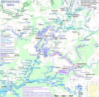
From the outflow from the Krüselin at the Krüseliner mill to the confluence with the Great Küstrinsee of the Lychener waters , the stream is 5.445 km long, but a large part of its water definitely comes from the rear end of the 1.72 km long Krüselinsee. This is where the groundwater seeps from the Dreetzsee lake , only four hundred meters away , whose water level is almost ten meters higher. On this path, which forms the natural runoff of the Feldberg lakes , they sometimes give off more water than over the Isernpurt, which is artificially created to relieve floods .
As a border stream, the Mechowbach flows through the small and large Mechowsee lakes . It leaves the border at the Kolbatzer mill pond and passes the Schreibermühle shortly before it flows into the Großer Küstrinsee.
In addition to the lakes in its course, the Mechowbach drains other lakes: A ditch leads from the Rohrpöhlen through Goschsee and Weutschsee to the Great Mechowsee. The Torgelowseeffluter flows through the Krummensee and Aalsee and flows into the lowest kilometer of the Mechowbach. Other lakes give off their water through the groundwater.
Surname
In most of the maps, the brook only bears the name Mechowbach as a border brook, then the common name Mühlenbach. The responsible water and soil association Uckermark-Havel calls it Mechowbach in full.
Individual evidence
- ↑ a b Map portal environment Mecklenburg-Western Pomerania
- ^ Brandenburg-Viewer: Digital topographic map
