Lychener Stadtsee
| Lychener Stadtsee | ||
|---|---|---|

|
||
| City lake | ||
| Geographical location | District of Uckermark , Brandenburg , Germany | |
| Tributaries | from the Zenssee and Nesselpfuhl | |
| Drain | Transition to the Großer Lychensee | |
| Places on the shore | Lychen | |
| Data | ||
| Coordinates | 53 ° 12 '31 " N , 13 ° 18' 33" E | |
|
|
||
| Altitude above sea level | 52.5 m above sea level NHN | |
| surface | 19.7 ha | |
| Maximum depth | 7 m | |

|
||
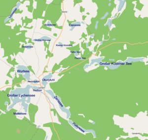
The city lake is centrally located in the urban area of Lychen in the northeast of the state of Brandenburg. It is the center of the Lychener Seenkreuz, which consists of seven lakes, and is directly connected at its western end to the Großer Lychensee and the Oberpfuhl in the east. The elliptical lake is a little over 900 meters long and a little over 350 meters wide. The summer visibility is 1.3 m.
The lake drains via the Woblitz (hydrologically also called Lychener waters ) to the Havel . It is also part of the Federal Waterway Lychener Gewässer (LyG), which begins at its eastern end.
The city lake is one of the Uckermärkischen lakes . The Fürstenberg / Havel – Lychen – Templin trolley line runs past him to the west and south .
Flora and fauna
The lake is very rich in nutrients. The main species of fish are eel, tench, pikeperch.
See also
Individual evidence
- ↑ ELWIS Viewer, Federal Waterways and Shipping Administration. Retrieved June 16, 2020 .


