Nesselpfuhl
| Nesselpfuhl | ||
|---|---|---|

|
||
| Nesselpfuhl in winter | ||
| Geographical location | Uckermark | |
| Places on the shore | Lychen | |
| Location close to the shore | Fürstenberg / Havel | |
| Data | ||
| Coordinates | 53 ° 12 '49 " N , 13 ° 18' 32" E | |
|
|
||
| Altitude above sea level | 52.6 m above sea level HN | |
| surface | 21.4 ha | |
| Maximum depth | 6 m | |

|
||
The Nesselpfuhl is in the northeast of Germany at Lychen situated lake .
geography
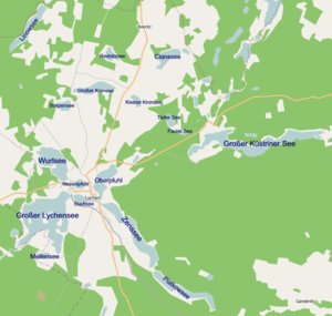
The Nesselpfuhl is a lake in the Uckermark district near Lychen and is part of the Uckermark Lakes Nature Park . Together with Oberpfuhl and Stadtsee, it encloses the old town of Lychen like an island. The Wurlflut creates a connection to the Wurlsee . There is also a canal connection to the Stadtsee and the Großer Lychensee .
features
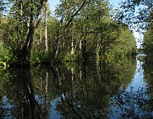
The Nesselpfuhl is 21.40 hectares and a maximum of 6 m deep. The water is very rich in nutrients and almost completely overgrown with water lilies and reeds on the bank. The wind conditions are bad and the summer visibility under water is 1 m.
ecology
The main fish species are: tench, pike, pikeperch, perch and eel. In addition to ospreys , many water birds such as grebes and coots can also be observed. The lake is also home to a population of the red eared slider turtle .
Important information
Fishing on the lake is only permitted with a fishing license. Driving on with motor boats is also prohibited. The information about the lake comes from the official website of the city of Lychen.

