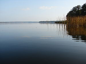
Stolpsee
| Stolpsee | ||
|---|---|---|

|
||
| The Stolpsee | ||
| Geographical location | City of Fürstenberg / Havel , Oberhavel district | |
| Tributaries | Havel , Woblitz | |
| Drain | Havel | |
| Places on the shore | Himmelpfort | |
| Data | ||
| Coordinates | 53 ° 10 '30 " N , 13 ° 12' 44" E | |
|
|
||
| Altitude above sea level | 51.5 m above sea level NHN | |
| surface | 3.71 km² | |
| volume | 24,650,000 m³ | |
| Maximum depth | 13 m | |
| Middle deep | 6.64 m | |
The Stolpsee is a natural lake in the north of the state of Brandenburg .
geography
The Stolpsee lies in the area of the district of Himmelpfort of the city of Fürstenberg / Havel in the natural area of the Neustrelitz Kleinseenland . It is the eastern link of a series of lakes in the tongue basin of the Fürstenberger Eisrandlage , before the breakthrough of the Havel through the Fürstenberg terminal moraine . The banks of the Stolpsee are not very indented. Only in the southwest does a peninsula protrude into the lake. A small island is in front of the funnel-shaped outflow of the Havel in the south. Its water level covers an area of 371 hectares and is 52 m above sea level. NHN . The water of the Havel enters the lake from Fürstenberg / Havel in the west and leaves it in the south towards Bredereiche and Zehdenick . In the northeast, the Woblitz connects the Stolpsee with the lakes around Lychen ( Lychener waters ). The maximum depth of the Stolpsee is 13 meters with an approximate length of 3.6 kilometers and a width of up to 1.4 kilometers.
history
The lake was first mentioned in a document as early as 1299 ( stagnum Stolp ). Along with 38 other lakes named above, it was part of the initial equipment of the Himmelpfort monastery . The monastery received the sole right of use from the Brandenburg margrave. The old Polish basic form * Stolp- zu * stolp, p.słup, č sloup, = column, bar, was interpreted as a device in the river for fishing or fish farming. The other possibility of interpretation relates to stakes or posts on traffic routes or river crossings. The latter applies to Stolp. At Stolp there was certainly a river crossing (over the Woblitz); in the deed of foundation of 1299, a locality Stolpenbrück was named, which was safely located near the village of Stolp .
Allegedly, shortly before the end of the Second World War , an SS detachment had 18 boxes containing 350 kg of gold and 100 kg of platinum by concentration camp prisoners sunk in the Stolpsee. Subsequently, the prisoners are said to have been shot. The gold is said to have been part of the gold stolen by Hermann Göring during the war years . In 1981 the Stern editor Gerd Heidemann informed the management of the Ministry for State Security about the alleged treasure, which then carried out the "Nazi Gold" operation without any result.
On the peninsula protruding into the lake in the southwest, a holiday camp of the VEB Synthesewerk Schwarzheide was housed during the GDR era ( location ). Today a youth addiction aid of the Evangelisches Johannesstifts Jugendhilfe gGmbH is housed there. The lake is managed by the lake fishery Himmelpfort GbR and FB Gensch .
The Stolpsee is part of the 97 kilometer-long federal waterway Obere Havel-Wasserstraße (OHW) of waterway class I; The Eberswalde Waterways and Shipping Office is responsible .
ecology
The Stolpsee is eutrophic and almost completely surrounded by broad reeds . Flat moor areas , wet meadows and alder forests are located behind the bank . In the southeast lies the forest area of the Himmelpforter Heide . Due to strong waves, aquatic plant populations only occur in protected bays. The Stolpsee is part of the protected landscape Fürstenberger forest and lake area and thus part of the Uckermark Lakes nature reserve .
Web links
- The Stolpsee at www.luis.brandenburg.de (PDF; 224 kB)
Individual evidence
- ↑ Adolph Friedrich Johann Riedel : Codex Diplomaticus Brandenburgensis A. First main part or collection of documents on the history of spiritual foundations, noble families, as well as the towns and castles of the Mark Brandenburg, XIII. Band, Die Uckermark: Lychen, Zehdenik, Templin, Angermünde, Chorin Monastery; Uckermark documents. Berlin, Reimer 1857 Online at Google Books .
- ↑ Reinhard E. Fischer (co-authors: Elzbieta Foster, Klaus Müller, Gerhard Schlimpert, Sophie Wauer & Cornelia Willich): Brandenburgisches Namenbuch. Part 10. The names of the waters of Brandenburg. 369 p., Verlag Hermann Böhlaus Successor, Weimar 1996 ISBN 3-7400-1001-0 (p. 264).
- ↑ Berliner Zeitung: The treasure in the Stolpsee .
- ↑ Berliner Zeitung: 18 boxes full of gold and platinum .
- ↑ youth addiction help restart the Stolpsee.
- ↑ Sidowsee water profile on anglermap.de .
- ↑ Directory E, Ser. No. 39 of the Chronicle ( Memento of the original from July 22, 2016 in the Internet Archive ) Info: The archive link was inserted automatically and has not yet been checked. Please check the original and archive link according to the instructions and then remove this notice. , Federal Waterways and Shipping Administration.
